
-
Federal
EMIT L2B Methane Enhancement Data 60 m V002
National Aeronautics and Space Administration —
The Earth Surface Mineral Dust Source Investigation (EMIT) instrument measures surface mineralogy, targeting the Earth’s arid dust source regions. EMIT is installed... -
Federal
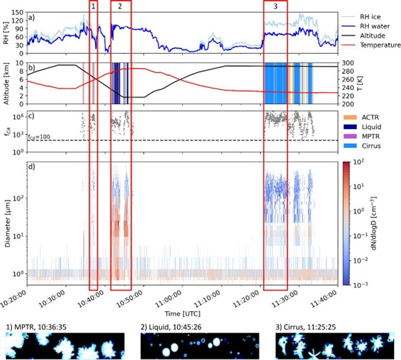
ATom: Dominant Role of Mineral Dust in Cirrus Cloud Formation
National Aeronautics and Space Administration —
This dataset provides: (1) In situ dust aerosol concentration measurements over remote tropical Pacific and Atlantic Oceans by NOAA Particle Analysis by Laser Mass... -
Federal
EMIT L4 Earth System Model Products V001
National Aeronautics and Space Administration —
The Earth Surface Mineral Dust Source Investigation (EMIT) instrument measures surface mineralogy, targeting the Earth’s arid dust source regions. EMIT is installed... -
Federal
MASTER: Geological Earth Mapping Experiment (GEMx), California-Arizona, Summer 2023
National Aeronautics and Space Administration —
This dataset includes Level 1B (L1B) and Level 2 (L2) data products from the MODIS/ASTER Airborne Simulator (MASTER) instrument. The spectral data were collected... -
Federal
EMIT L2A Estimated Surface Reflectance and Uncertainty and Masks 60 m V001
National Aeronautics and Space Administration —
The Earth Surface Mineral Dust Source Investigation (EMIT) instrument measures surface mineralogy, targeting the Earth’s arid dust source regions. EMIT is installed... -
Federal
Fifteen days of microgravity causes growth in calvaria of mice (STS-131)
National Aeronautics and Space Administration —
Bone growth may occur in spaceflight as a response to skeletal unloading and head-ward fluid shifts. While unloading causes significant loss of bone mass and density... -
Federal
ABoVE: Active Layer Soil Characteristics at Selected Sites Across Alaska
National Aeronautics and Space Administration —
This dataset provides soil active layer characteristics from nine locations across Alaska. Soil samples were collected in 2016 except for one site which was sampled... -
Federal
LBA-ECO ND-02 Soil Gas Flux, Rainfall Exclusion, km 67, Tapajos National Forest
National Aeronautics and Space Administration —
Moist tropical forests in Amazonia and elsewhere are subjected to increasingly severe drought episodes through the El Nino-Southern Oscillation (ENSO) and possibly... -
Federal
SBG 2024 TIM Meeting Summary: Current Progress and Future Goals of the SBG Mission
National Aeronautics and Space Administration —
This report summarizes the community discussions at the 2024 NASA Surface Biology and Geology (SBG) Technical Interchange Meeting (TIM) from May 29 to 31, 2024, in... -
Federal
LBA-ECO ND-02 Trace Gas Flux from Forest Soil, Para, Brazil : 1999-2001
National Aeronautics and Space Administration —
Understanding secondary successional processes in Amazonian terrestrial ecosystems is becoming increasingly important as continued deforestation expands the area that... -
Federal
A Global Database of Soil Phosphorus Compiled from Studies Using Hedley Fractionation
National Aeronautics and Space Administration —
This data set provides concentrations of soil phosphorus (P) compiled from the peer-reviewed literature that cited the Hedley fractionation method (Hedley and... -
Federal
CALIPSO Lidar Level 3 Tropospheric Aerosol Profiles, Cloudy Sky Opaque Data, Standard V4-21
National Aeronautics and Space Administration —
CAL_LID_L3_Tropospheric_APro_CloudySkyOpaque-Standard-V4-21 is the Cloud-Aerosol Lidar and Infrared Pathfinder Satellite Observation (CALIPSO) Lidar Level 3... -
Federal
ATom: Development of Cloud Indicator Algorithm Using Airborne Observations from CAPS
National Aeronautics and Space Administration —
This dataset is the basis for the development of the Cloud Indicator, a novel algorithm that automatically detects and classifies measurement periods inside clouds.... -
Federal
Effect of varying amounts of simulated lunar soil batch #005 upon growth of lettuce explants
National Aeronautics and Space Administration —
The following general conclusions can be made concerning the use of tissue culture for assaying the effects of mineral elements from simulated lunar soil or other... -
Federal
Geoecology: County-Level Environmental Data for the United States, 1941-1981
National Aeronautics and Space Administration —
The Geoecology database is a compilation of environmental data for the period 1941 to 1981. The Geoecology database contains selected data on terrain and soils, water... -
Federal
EMIT L2B Estimated Methane Plume Complexes 60 m V001
National Aeronautics and Space Administration —
The Earth Surface Mineral Dust Source Investigation (EMIT) instrument measures surface mineralogy, targeting the Earth’s arid dust source regions. EMIT is installed... -
Federal
CALIPSO Lidar Level 3 Tropospheric Aerosol Profiles, Cloud Free Data, Standard V4-20
National Aeronautics and Space Administration —
CAL_LID_L3_Tropospheric_APro_CloudFree-Standard-V4-20 is the Cloud-Aerosol Lidar and Infrared Pathfinder Satellite Observation (CALIPSO) Lidar Level 3 Tropospheric... -
Federal
Soil Matric Potential, Dielectric, and Physical Properties, Arctic Alaska, 2018
National Aeronautics and Space Administration —
This dataset provides lab-measured soil properties, including soil water matric potential, soil dielectric properties, soil electrical conductivity, corresponding... -
Federal
CALIPSO Lidar Level 3 Tropospheric Aerosol Profiles, Cloud Free Data, Standard V4-21
National Aeronautics and Space Administration —
CAL_LID_L3_Tropospheric_APro_CloudFree-Standard-V4-21 is the Cloud-Aerosol Lidar and Infrared Pathfinder Satellite Observation (CALIPSO) Lidar Level 3 Tropospheric...

Official websites use .gov
A
.gov website belongs to an official government
organization in the United States.
Secure .gov websites use HTTPS
A
lock (
) or https:// means you’ve safely connected to
the .gov website. Share sensitive information only on official,
secure websites.