
-
Federal
Shuttle Radar Topography Mission (SRTM) Images
National Aeronautics and Space Administration —
Culminating more than four years of processing data, NASA and the National Geospatial-Intelligence Agency (NGA) have completed Earth's most extensive global... -
Federal
BOREAS HYD-08 DEM Data over the NSA-MSA and SSA-MSA in UTM Projection
National Aeronautics and Space Administration —
These DEMs were produced from digitized contours at a cell resolution of 100 meters. Vector contours of the area were used as input to a software package that... -
Federal
Maps of Vegetation Types and Physiographic Features, Imnavait Creek, Alaska
National Aeronautics and Space Administration —
This dataset provides the spatial distribution of vegetation types, soil carbon, and physiographic features in the Imnavait Creek area, Alaska. Specific attributes... -
Federal
CONTOUR REMOTE IMAGING SPECTROGRAPH GROUND OCF IMAGE DATA
National Aeronautics and Space Administration —
This dataset contains raw counts from the the imager of the CONTOUR Remote Imaging Spectrograph (CRISP) instrument during ground calibration in the Optical... -
Federal
VLA Hubble Deep Field 20-cm Source Catalog
National Aeronautics and Space Administration —
The authors have conducted a deep radio survey with the Very Large Array (VLA) at 1.4 GHz of a region containing the Hubble Deep Field (HDF). This survey overlaps... -
Federal
CLPX-Airborne: Infrared Orthophotography and Lidar Topographic Mapping, Version 1
National Aeronautics and Space Administration —
The data set consists of color infrared orthophotography (TerrainVision® - High resolution Topographic Mapping & Aerial Photography, with 6-inch pixel... -
Federal
NASA Expendable Launch Vehicle Launch Archive 2002
National Aeronautics and Space Administration —
A list of launch vehicles launched for NASA missions in 2002. -
Federal
CONTOUR TELEMETRY GSE DATA
National Aeronautics and Space Administration —
This dataset contains the raw telemetry from the Ground Support Equipment (GSE) facilities used to integrate the spacecraft components at JHU/APL in 2002. The... -
Federal
High-Resolution Radar Imagery, Digital Elevation Models, and Related GIS Layers for Barrow, Alaska, USA, Version 1
National Aeronautics and Space Administration —
This product set contains high-resolution Interferometric Synthetic Aperture Radar (IFSAR) imagery and geospatial data for the Barrow Peninsula (155.39 - 157.48 deg... -
Federal
Extremely Luminous X-Ray Source Candidates Catalog
National Aeronautics and Space Administration —
Using Chandra archive data, the authors conducted a thorough survey of luminous X-ray sources. They directly analyzed about 9400 Chandra ACIS observations and cross-... -
Federal
CONTOUR MISSION DOCUMENTATION SET V1.0
National Aeronautics and Space Administration —
This collection contains documentation created in support and anticipation of the CONTOUR mission, by various contributors. It is provided here 'as is', in the form... -
Federal
CONTOUR MISSION DOCUMENTATION SET V1.0
National Aeronautics and Space Administration —
This collection contains documentation created in support and anticipation of the CONTOUR mission, by various contributors. It is provided here 'as is', in the form... -
Federal
CONTOUR REMOTE IMAGING SPEC. GROUND OCF SPECTRAL DATA
National Aeronautics and Space Administration —
This dataset contains raw counts from the the spectrograph of the CONTOUR Remote Imaging Spectrograph (CRISP) instrument during ground calibration in the Optical... -
Federal
CONTOUR REMOTE IMAGING SPECTROGRAPH GROUND OCF IMAGE DATA
National Aeronautics and Space Administration —
This dataset contains raw counts from the the imager of the CONTOUR Remote Imaging Spectrograph (CRISP) instrument during ground calibration in the Optical... -
Federal
CONTOUR REMOTE IMAGING SPEC. GROUND OCF SPECTRAL DATA
National Aeronautics and Space Administration —
This dataset contains raw counts from the the spectrograph of the CONTOUR Remote Imaging Spectrograph (CRISP) instrument during ground calibration in the Optical... -
Federal
CONTOUR FORWARD IMAGER GROUND OCF DATA
National Aeronautics and Space Administration —
This dataset contains raw counts from the CONTOUR Forward Imager (CFI) instrument during ground calibration in the Optical Calibration Facility (OCF) at JHU/APL in 2002. -
Federal
TRMM Ground Validation Radar Site 3D Rain Map L3 1 month 2 km V7 (TRMM_3A55) at GES DISC
National Aeronautics and Space Administration —
The 3A55, 'Monthly 3-D Structure', provides radar site monthly 3-D structure information obtained from 2A55. The 2A55 'Radar Site 3-D Reflectivities', is composed of... -
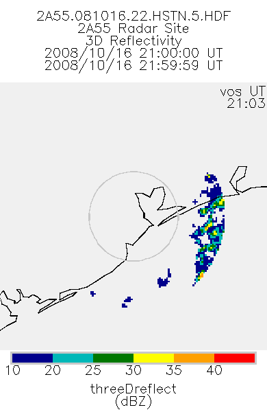
Federal
TRMM Ground Validation Radar Site 3D Reflectivity L2 1 hour V7 (TRMM_2A55) at GES DISC
National Aeronautics and Space Administration —
'Radar Site 3-D Reflectivities', is composed of 3 different fields. The first field has an array of 3-D reflectivities in Cartesian coordinates with a 2 km horizontal... -
Federal
China Dimensions Data Collection: Fundamental GIS: Digital Chart of China, 1:1M, Version 1
National Aeronautics and Space Administration —
The Fundamental GIS: Digital Chart of China, 1:1M, Version 1 consists of vector maps of China and surrounding areas. The maps include roads, railroads, drainage... -
Federal
CG 12 Chandra X-Ray Point Source Catalog
National Aeronautics and Space Administration —
The mysterious high Galactic latitude cometary globule CG 12 has been observed with the ACIS detector on board the Chandra X-Ray Observatory. 128 X-ray sources are...

Official websites use .gov
A
.gov website belongs to an official government
organization in the United States.
Secure .gov websites use HTTPS
A
lock (
) or https:// means you’ve safely connected to
the .gov website. Share sensitive information only on official,
secure websites.