
-
Federal
MISR Level 2 Surface parameters V002 recent views
National Aeronautics and Space Administration —
MIL2ASLS_2 is the Multi-angle Imaging SpectroRadiometer (MISR) Level 2 Land Surface parameters version 2 data product. It contains a variety of information on the... -
Federal
BOREAS AFM-06 Boundary Layer Height Data recent views
National Aeronautics and Space Administration —
Contains AFM-06 hourly inversion height measurements. -
Federal
OCIO FITARA Common Baseline Implementation Plan and Self-Assessment recent views
National Aeronautics and Space Administration —
This document outlines NASA's IT management and decision-making structure as well as the the Office of the Chief Information Officer's (OCIO) self-assessment against... -
Federal
BOREAS RSS-02 Extracted Reflectance Factors Derived from ASAS Imagery recent views
National Aeronautics and Space Administration —
Contains calculated bidirectional reflectance factor means derived from extractions of C130-based ASAS measurements made during BOREAS. -
Federal
BOREAS TE-18 Landsat TM Maximum Likelihood Classification Image of the SSA recent views
National Aeronautics and Space Administration —
A Landsat-5 TM image from 06-Aug-1990 was used to derive this classification, the objective of which is to provide BOREAS investigators with a data product that... -
Federal
Bowen Ratio Surface Flux: Smith (FIFE) recent views
National Aeronautics and Space Administration —
Retrieval of surface fluxes from a combination of satellite & surface platforms -
Federal
BOREAS TGB-07 Rainwater Herbicide and Organochlorine Concentration Data recent views
National Aeronautics and Space Administration —
Contains 1993 and 1994 herbicide concentrations in rain samples for TGB-07 in the SSA. -
Federal
BOREAS TE-08 Aspen Bark Chemistry Data recent views
National Aeronautics and Space Administration —
Contains bark biochemical data collected by TE-08. -
Federal
UARS Correlative UKMO Daily Gridded Stratospheric Assimilated Data V001 (UARZCUKM) at GES DISC recent views
National Aeronautics and Space Administration —
The UARS Correlative assimilation data from the U.K. Meteorological Office (UKMO) consists of daily model runs at 12:00 GMT as a means of providing an independent... -
Federal
UARS Solar-Stellar Irradiance Comparison Experiment (SOLSTICE) Level 3BS V018 (UARSO3BS) at GES DISC recent views
National Aeronautics and Space Administration —
The Solar-Stellar Irradiance Comparison Experiment (SOLSTICE) Level 3BS data product consists of daily, 1 nm resolution, solar spectral irradiances and selected solar... -
Federal
GRIP DOPPLER AEROSOL WIND LIDAR (DAWN) V1 recent views
National Aeronautics and Space Administration —
The GRIP Doppler Aerosol WiNd Lidar (DAWN) Dataset was collected by the Doppler Aerosol WiNd (DAWN), a pulsed lidar, which operated aboard a NASA DC-8 aircraft during... -
Federal
DXC'09 Framework recent views
National Aeronautics and Space Administration —
The DXC Framework is a collection of programs and APIs for running and evaluating diagnostic algorithms (DAs). It is complementary to system XML catalogs and... -
Federal
UARS Solar Ultraviolet Spectral Irradiance Monitor (SUSIM) Level 3BS V022 (UARSU3BS) at GES DISC recent views
National Aeronautics and Space Administration —
The Solar Ultraviolet Spectral Irradiance Monitor (SUSIM) Level 3BS data product consists of daily, 1 nm resolution, solar spectral irradiances and selected solar... -
Federal
BOREAS Site and Area Geographic Coordinate Information recent views
National Aeronautics and Space Administration —
Geographic coordinate and other site information from several sources throughout the experiment period. The final set of information is organized into two data sets... -
Federal
BOREAS TE-05 Leaf Carbon Isotope Data recent views
National Aeronautics and Space Administration —
Contains leaf carbon isotope data collected by TE-05 during 1994. -
Federal
BOREAS TE-05 Diurnal CO2 Canopy Profile Data recent views
National Aeronautics and Space Administration —
Contains the CO2 profile concentration measurements made by the TE-05 BOREAS team in the NSA and SSA. -
Federal
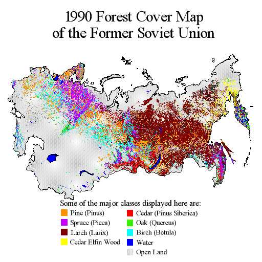
RLC Forest Cover Map of the Former Soviet Union, 1990 recent views
National Aeronautics and Space Administration —
This data set is a 1:2.5 million scale forest cover map for the land area of the Former Soviet Union that was completed in 1990 (Garsia 1990). There are forty-five... -
Federal
BOREAS Daedalus TMS Level-0 Imagery: Digital Counts in BIL Format recent views
National Aeronautics and Space Administration —
The level-0 Daedalus TMS imagery, along with the other remotely sensed images, was collected to provide spatially extensive information about radiant energy over the... -
Federal
BOREAS Level-1B TIMS Imagery: At Sensor Radiance in BSQ Format recent views
National Aeronautics and Space Administration —
TIMS imagery, along with other aircraft images, was collected to provide spatially extensive information over the primary study areas. The level-1B TIMS images cover...

Official websites use .gov
A
.gov website belongs to an official government
organization in the United States.
Secure .gov websites use HTTPS
A
lock (
) or https:// means you’ve safely connected to
the .gov website. Share sensitive information only on official,
secure websites.