
-
Federal
Washington Double Star Catalog
National Aeronautics and Space Administration —
The Washington Double Star Catalog (WDS), maintained by the United States Naval Observatory (USNO), is the world's principal database of astrometric double and... -
Federal
Geostationary Lightning Mapper (GLM) Thunder Hour Data Product
National Aeronautics and Space Administration —
The Geostationary Lightning Mapper (GLM) is the first optical lightning detector in geostationary orbit, and GLM sensors operate aboard the National Oceanic and... -
Federal
HAQAST Sentinel-5P TROPOMI Nitrogen Dioxide (NO2) CONUS Monthly Level 3 0.01 x 0.01 Degree Gridded Data V2.4 (HAQ_TROPOMI_NO2_CONUS_M_L3) at GES DISC
National Aeronautics and Space Administration —
This product provides level 3 monthly averages of tropospheric Nitrogen dioxide (NO2) vertical column density derived from the level 2 Tropospheric Monitoring... -
Federal
CMS GOSAT and ObsPack L4 Top-down yearly methane emissions for individual sectors at 0.5x0.625 degrees for North America V1 (CMS_GO_CH4_SEC_TDYC_NA)
National Aeronautics and Space Administration —
Methane emissions are provided by sector in the contiguous United States (CONUS), Canada, and Mexico by inverse analysis of in situ (GLOBALVIEWplus CH4ObsPack) and... -
Federal
TOLNet NASA Langley Research Center Data
National Aeronautics and Space Administration —
TOLNet_LaRC_Data is the lidar data collected by the Langley Mobile Ozone Lidar (LMOL) at NASA Langley Research Center (LaRC) as part of the Tropospheric Ozone Lidar... -
Federal
NACP Aboveground Biomass and Carbon Baseline Data, V.2 (NBCD 2000), U.S.A., 2000
National Aeronautics and Space Administration —
The NBCD 2000 (National Biomass and Carbon Dataset for the Year 2000) data set provides a high-resolution (30 m) map of year-2000 baseline estimates of basal area-... -
Federal
Global Historical Climatology Network, 1753-1990
National Aeronautics and Space Administration —
This data set contains monthly temperature, precipitation, sea-level pressure, and station-pressure data for thousands of meteorological stations worldwide. The... -
Federal
United States Naval Observatory B1.0 Catalog
National Aeronautics and Space Administration —
This all-sky catalog, described in Monet et al. (2003), consists of positions, proper motions, magnitudes, and other measured quantities for 1,045,175,762 objects.... -
Federal
TOLNet Environment and Climate Change Canada Data
National Aeronautics and Space Administration —
TOLNet_ECCC_Data is the lidar data collected by the Autonomous Mobile Ozone LIDAR instrument for Tropospheric Experiments (AMOLITE) lidar at Environment and Climate... -
Federal
TOLNet NASA Jet Propulsion Laboratory Data
National Aeronautics and Space Administration —
TOLNet_JPL_Data are lidar data collected by several ozone Differential Absorption Lidar instruments developed at the NASA Jet Propulsion Laboratory Table Mountain... -
Federal
LBA Regional Global Historical Climatology Network, V. 1, 1832-1990
National Aeronautics and Space Administration —
This data set consists of a subset of the Global Historical Climatology Network (GHCN) Version 1 database for the study area of the Large Scale Biosphere-Atmosphere... -
Federal
TOLNet NOAA Chemical Sciences Laboratory Data
National Aeronautics and Space Administration —
TOLNet_CSL_Data is the lidar data collected by the Tunable Optical Profile for Aerosol and oZone (TOPAZ) lidar at the NOAA Chemical Sciences Laboratory (CSL) in... -
Federal
GPM Ground Validation Dual-frequency Dual-polarized Doppler Radar (D3R) OLYMPEX
National Aeronautics and Space Administration —
The GPM Ground Validation Dual-frequency Dual-polarized Doppler Radar (D3R) OLYMPEX dataset contains radar reflectivity, velocity, differential reflectivity,... -
Federal
ACEPOL Research Scanning Polarimeter (RSP) Remotely Sensed Data Version 1
National Aeronautics and Space Administration —
ACEPOL Research Scanning Polarimeter (RSP) Remotely Sensed Data (ACEPOL_AircraftRemoteSensing_RSP_Data) are remotely sensed measurements collected by the Research... -
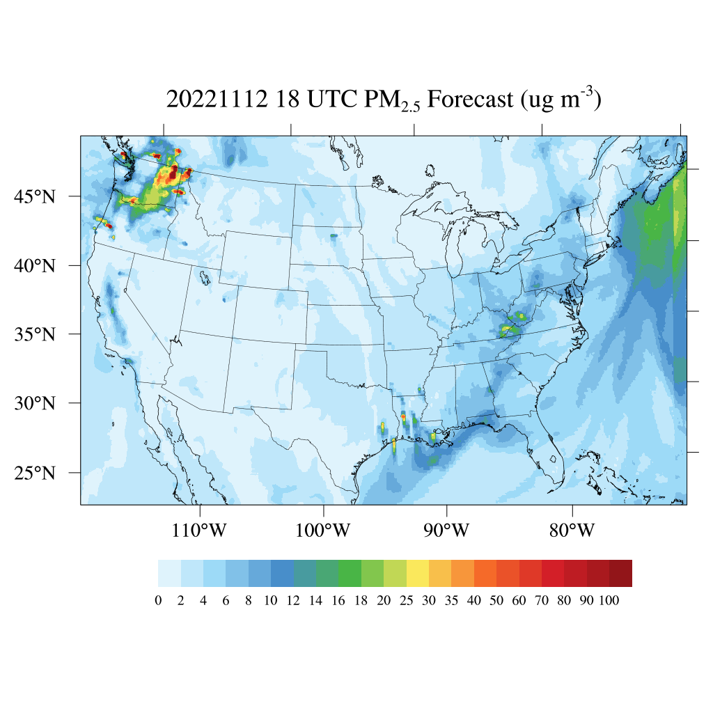
Federal
HAQES 3-Hourly Ensemble mean surface total PM2.5 concentration, North America V1 (HAQES_NA_PM25_TOT) at GES DISC
National Aeronautics and Space Administration —
This product provides HAQES 3-hourly ensemble mean surface total PM2.5 concentration over the continental United States (CONUS) and surrounding regions. The data is... -
Federal
Merged Sentinel-3A and Sentinel-3B OLCI Global Binned CyAN Project, True Color (TC) Data, version 5.0
National Aeronautics and Space Administration —
Cyanobacteria Assessment Network (CyAN) is a multi-agency project among EPA, the National Aeronautics and Space Administration (NASA), the National Oceanic and... -
Federal
BASIN TCP Stable Isotope Composition of CO2 in Terrestrial Ecosystems
National Aeronautics and Space Administration —
This data set reports stable isotope ratio data of CO2 (13C/12C and 18O/16O) associated with photosynthetic and respiratory exchanges across the biosphere-atmosphere... -
Federal
SAFARI 2000 Global Historical Climatology Network, V. 1, 1874-1990
National Aeronautics and Space Administration —
This data set consists of a southern African subset of the Global Historical Climatology Network (GHCN) Version 1 database. All stations with the following bounding... -
Federal
NARSTO-NE Selected NEXRAD Images for 1995
National Aeronautics and Space Administration —
The NARSTO_NE_NEXRAD_IMAGES data set contains selected NEXt Generation RADar (NEXRAD) weather images from the northeastern United States for the summer of 1995. The... -
Federal
COASTAL Project
National Aeronautics and Space Administration —
Measurements made along the Eastern Seaboard of the United States, North Atlantic Bight, and Gulf Stream between 2000 and 2010.

Official websites use .gov
A
.gov website belongs to an official government
organization in the United States.
Secure .gov websites use HTTPS
A
lock (
) or https:// means you’ve safely connected to
the .gov website. Share sensitive information only on official,
secure websites.