
-
Federal
GPM PR on TRMM Reflectivity, Precipitation Characteristics and Rate, at Surface and Profile L2 1.5 hours V07 (GPM_2APR) at GES DISC
National Aeronautics and Space Administration —
This is the new, GPM-like, format for TRMM Precipitation Radar L2 data that now incorporates what was known as 2A21, 2A23 and 2A25 datasets.The primary purpose of... -
Federal
VIIRS/JPSS2 Day/Night Band 6-Min L1B Swath SDR 750m NRT
National Aeronautics and Space Administration —
The Near Real Time (NRT) VIIRS Level 1 and Level 2 swath (VJ202DNB_NRT) product is single NASA VIIRS panchromatic Day-Night band (DNB) calibrated radiance product.... -
Federal
VIIRS/NPP BRDF/Albedo NBAR at Solar Noon Band M8 Daily L3 Global 30ArcSec CMG V001
National Aeronautics and Space Administration —
The VNP43D86 Version 1 data product was decommissioned on July 31, 2025. Users are encouraged to use the VNP43D86 and VJ143D86 Version 2 data products.The NASA/NOAA... -
Federal
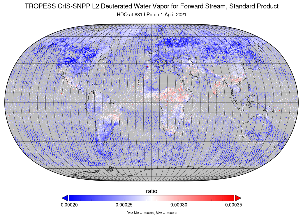
TROPESS CrIS-SNPP L2 Deuterated Water Vapor for Forward Stream, Standard Product V1 (TRPSDL2HDOCRSFS) at GES DISC
National Aeronautics and Space Administration —
The TROPESS CrIS-SNPP L2 Deuterated Water Vapor for Forward Stream, Standard Product contains the vertical distribution of the retrieved atmospheric state of semi-... -
Federal
MISR Level 3 Global Cloud public Product in netCDF format covering a day V002
National Aeronautics and Space Administration —
MI3DCLDN_2 is the Multi-angle Imaging SpectroRadiometer (MISR) Level 3 Global Cloud public Product in netCDF format covering a day version 2. It contains the public... -
Federal
ACE Electron Proton Alpha Monitor (EPAM) LEFS150 MFSA, Spacecraft Frame, Sectored Ion and Electron Count Rates, 5 min Averages
National Aeronautics and Space Administration —
5min-averaged sectored count rates from LEFS150. -
Federal
MEaSUREs MODIS Mosaic of Antarctica 2013-2014 (MOA2014) Image Map, Version 1
National Aeronautics and Space Administration —
This data set, part of the NASA Making Earth System Data Records for Use in Research Environments (MEaSUREs) Program, includes two image maps - a snow grain size map... -
Federal
SPICES Lynx Field Chandra X-Ray Source Catalog
National Aeronautics and Space Administration —
This table contains the first results on field X-ray sources detected in a deep, 184.7 ks observation with the Advanced CCD Imaging Spectrometer (ACIS-I) on the... -
Federal
BARREL 2Y X-ray Spectrometer (FSPC) Bremsstrahlung X-ray Spectrum Fast Time Resolution, Level 2, 0.05 s Data
National Aeronautics and Space Administration —
FSPC: Six channels of fast time resolution, 50 ms, Bremsstrahlung X-ray spectra detected with a NaI Scintillator. Each channel is separated in its own variable:... -
Federal
BARREL 1U Rate Counter (RCNT) NaI Scintillator Diagnostics, Level 2, 4 s Data
National Aeronautics and Space Administration —
This data product consists of measurements from rate counters. The rate count data are diagnostic fields, have uncalibrated energy ranges, and wrap near or above... -
Federal
Optical Thickness Data: Staff (FIFE)
National Aeronautics and Space Administration —
Aerosol optical thickness in conjunction with an atmospheric model can provide estimates of atmospheric effects on transmitted and reflected solar radiation. These... -
Federal
AVIRIS-Classic: L1B Calibrated Radiance, Facility Instrument Collection, V1
National Aeronautics and Space Administration —
This dataset contains Level 1B (L1B) orthocorrected, scaled radiance image files as well as files of observational geometry and illumination parameters and supporting... -
Federal
Spitzer South Ecliptic Pole MIPS 24 micron Point Source Catalog
National Aeronautics and Space Administration —
The Spitzer/MIPS 24 and 70 μm imaging of an 11.5 square degree region near the South Ecliptic Pole (SEP) has been carried out in order to complement sub-millimeter... -
Federal
BOREAS TE-10 Leaf Optical Properties for SSA Species
National Aeronautics and Space Administration —
The BOREAS TE-10 team collected several data sets in support of its efforts to characterize and interpret information on the reflectance, transmittance, gas exchange,... -
Federal
BOREAS TE-18 Landsat TM Physical Classification Image of the NSA
National Aeronautics and Space Administration —
The objective of this classification is to provide the BOREAS investigators with a data product that characterizes the land cover of the NSA. A Landsat-5 TM image... -
Federal
BeppoSAX High-Energy Large Area Survey (HELLAS) Radio Source Catalog
National Aeronautics and Space Administration —
This table contains results of a complete radio follow-up obtained with the VLA and ATCA radio telescopes down to a 6-cm flux limit of about 0.3 mJy (3-sigma) of all... -
Federal
BBXRT Archive
National Aeronautics and Space Administration —
The BBXRT database table contains information about each observation made by the Broad Band X-Ray Telescope. It includes a catalog of observations and spectral and... -
Federal
IBEX High Energy Neutral Atom Imager (Hi) Data Release 07, not Compton-Getting corrected, not Survival Probability corrected, Antiram direction, West Longitude Ecliptic Maps, Level H3 (H3), annually averaged Data
National Aeronautics and Space Administration —
1: The Interstellar Boundary Explorer (IBEX) has operated in space since 2008 updating our knowledge of the outer heliosphere and its interaction with the local... -
Federal
SWOT Simulated Level 2 North America Continent High Rate River Vectors Product Version 1.0
National Aeronautics and Space Administration —
This dataset contains a simulated river data product to be provided by the Surface Water and Ocean Topography (SWOT) mission. SWOT will provide a global coverage but...

Official websites use .gov
A
.gov website belongs to an official government
organization in the United States.
Secure .gov websites use HTTPS
A
lock (
) or https:// means you’ve safely connected to
the .gov website. Share sensitive information only on official,
secure websites.