
-
Federal
GLDAS Catchment Land Surface Model L4 daily 0.25 x 0.25 degree GRACE-DA1 V2.2 (GLDAS_CLSM025_DA1_D) at GES DISC recent views
National Aeronautics and Space Administration —
NASA Global Land Data Assimilation System Version 2 (GLDAS-2) has three components: GLDAS-2.0, GLDAS-2.1, and GLDAS-2.2. GLDAS-2.0 is forced entirely with the... -
Federal
Projected Future LOCA Statistical Downscaling (Localized Constructed Analogs) Statistically downscaled CMIP5 climate projections for North America recent views
Department of the Interior —
LOCA is a statistical downscaling technique that uses past history to add improved fine-scale detail to global climate models. We have used LOCA to downscale 32... -
Federal
GPM Ground Validation Environment Canada (EC) Visibility Sensor FD12P C3VP V1 recent views
National Aeronautics and Space Administration —
The GPM Ground Validation (GV) Environment Canada (EC) Visibility Sensor FD12P C3VP dataset consists of visibility and precipitation data collected at the Environment... -
Federal
GPM ATMS on NOAA-21 (GPROF) Climate-based Radiometer Precipitation Profiling L3 1 day 0.25 degree x 0.25 degree V07 (GPM_3GPROFNOAA21ATMS_DAY_CLIM) at GES DISC recent views
National Aeronautics and Space Administration —
Version 07 is the current version of the data set. Older versions are no longer available and have been superseded by Version 07. The "CLIM" products differ from... -
Federal
NOAA/WDS Paleoclimatology - Southern California July Temperature and Annual Precipitation Reconstructions - Full-Holocene recent views
National Oceanic and Atmospheric Administration, Department of Commerce —
This archived Paleoclimatology Study is available from the NOAA National Centers for Environmental Information (NCEI), under the World Data Service (WDS) for... -
Federal
CHIRPS Version 2.0, Precipitation, Global, 0.05°, 5-Day, 1981-present recent views
National Oceanic and Atmospheric Administration, Department of Commerce —
This dataset has 5-day (pentad) averages of the Climate Hazards Group InfraRed Precipitation with Station data (CHIRPS), which is quasi-global rainfall data set.... -
Federal
Weather station data, St. Louis, Missouri recent views
Department of the Interior —
The text file "Weather Station Data, St. Louis, Missouri.txt" contains hourly data collected by a Campbell Scientific ET107 weather station located in St. Louis,... -
Federal
GPM Ground Validation Global Flood Monitoring System (GFMS) Flood Maps IFloodS V1 recent views
National Aeronautics and Space Administration —
The GPM Ground Validation Global Flood Monitoring System (GFMS) Flood Maps IFloodS dataset contains global flood estimates on a 0.25 degree spatial resolution every 3... -
Federal
CHIRPS Version 2.0, Precipitation, Global, 0.05°, Monthly, 1981-present recent views
National Oceanic and Atmospheric Administration, Department of Commerce —
This dataset has monthly averages of the Climate Hazards Group InfraRed Precipitation with Station data (CHIRPS), which is quasi-global rainfall data set. Spanning... -
Federal
California Basin Characterization Model Downscaled Climate and Hydrology recent views
Department of the Interior —
The California Basin Characterization Model (CA-BCM 2014) dataset provides historical and projected climate and hydrologic surfaces for the region that encompasses... -
Federal
GPM GROUND VALIDATION PRECIPITATION VIDEO IMAGER (PVI) GCPEX V1 recent views
National Aeronautics and Space Administration —
The GPM Ground Validation Precipitation Video Imager (PVI) GCPEx dataset collected precipitation particle images and drop size distribution data from November 2011... -
Federal
First ISCCP Regional Experiment (FIRE) Atlantic Stratocumulus Transition Experiment (ASTEX) PSU Malcolm Baldridge Data recent views
National Aeronautics and Space Administration —
The First ISCCP Regional Experiments have been designed to improve data products and cloud/radiation parameterizations used in general circulation models (GCMs).... -
Federal
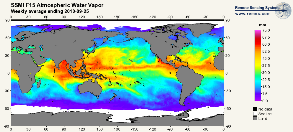
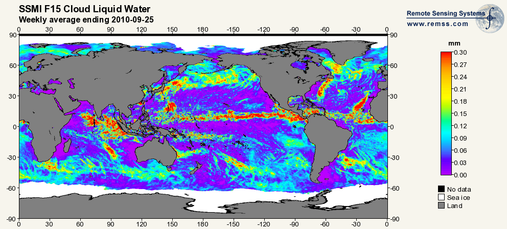
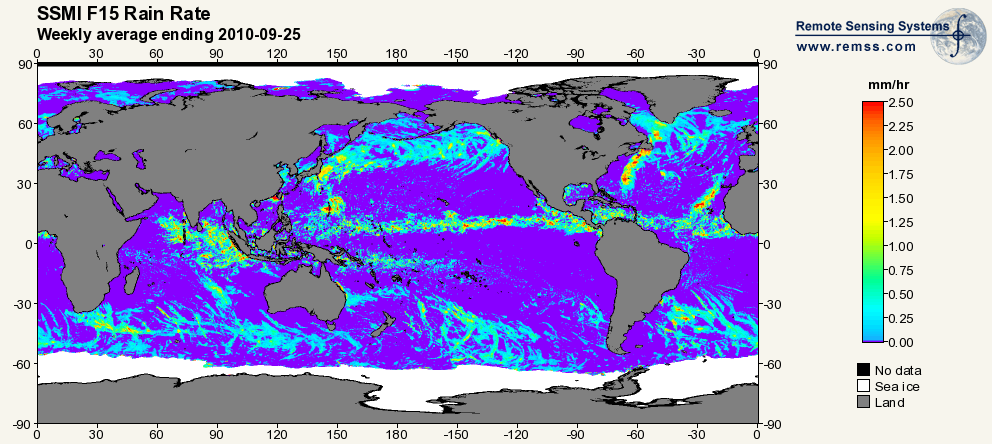
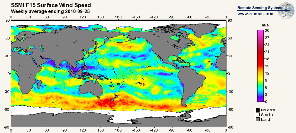
RSS SSM/I OCEAN PRODUCT GRIDS WEEKLY AVERAGE FROM DMSP F15 NETCDF V7 recent views
National Aeronautics and Space Administration —
The RSS SSM/I Ocean Product Grids Weekly Average from DMSP F15 netCDF dataset is part of the collection of Special Sensor Microwave/Imager (SSM/I) and Special Sensor... -
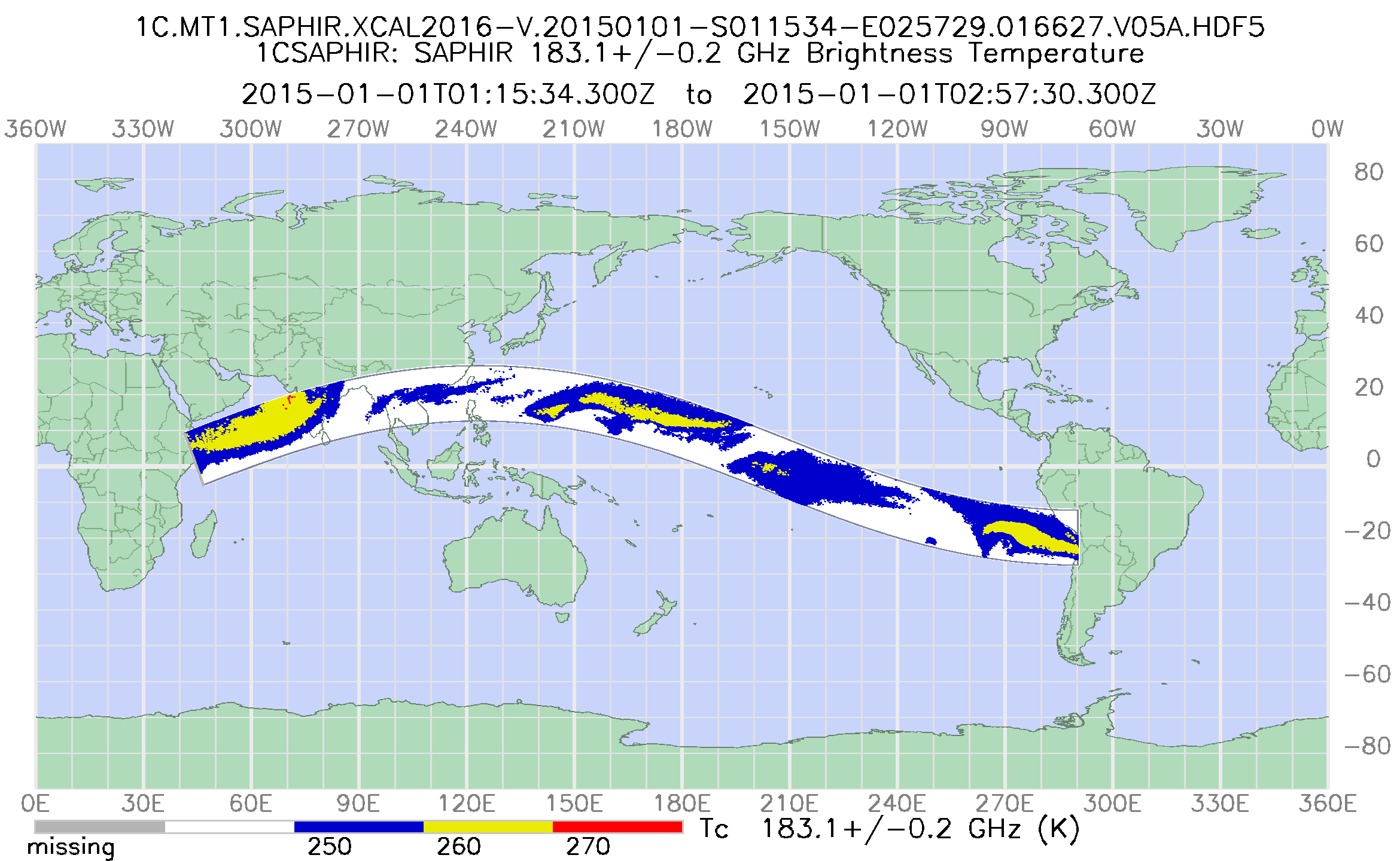
Federal
GPM SAPHIR on MT1 Common Calibrated Brightness Temperature L1C 1.5 hours 10 km V07 (GPM_1CMT1SAPHIR) at GES DISC recent views
National Aeronautics and Space Administration —
Version 07 is the current version of the data set. Older versions will no longer be available and have been superseded by Version 07. 1CAMSR2 contains common... -
Federal
GPM ATMS on NOAA-21 (GPROF) Climate-based Radiometer Precipitation Profiling L2A 1.5 hours 17 km V07 (GPM_2AGPROFNOAA21ATMS_CLIM) at GES DISC recent views
National Aeronautics and Space Administration —
Version 07 is the current version of the data set. The "CLIM" products differ from their "regular" counterparts (without the "CLIM" in the name) by the ancillary data... -
Federal
GPM ATMS on NOAA-21 (GPROF) Climate-based Radiometer Precipitation Profiling L3 1 month 0.25 degree x 0.25 degree V07 (GPM_3GPROFNOAA21ATMS_CLIM) at GES DISC recent views
National Aeronautics and Space Administration —
Version 07 is the current version of the data set. Older versions are no longer available and have been superseded by Version 07. The "CLIM" products differ from... -
Federal
GPM Ground Validation Composite Satellite Overpasses OLYMPEX V4 recent views
National Aeronautics and Space Administration —
The GPM Ground Validation Composite Satellite Overpasses OLYMPEX dataset provides brightness temperature, precipitation, and total column water vapor estimates from... -
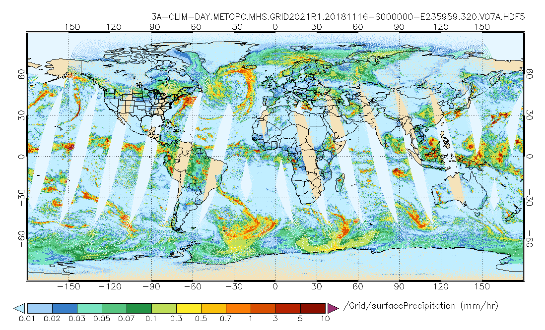
Federal
GPM MHS on METOP-C (GPROF) Climate-based Radiometer Precipitation Profiling L3 1 day 0.25 degree x 0.25 degree V07 (GPM_3GPROFMETOPCMHS_DAY_CLIM) at GES DISC recent views
National Aeronautics and Space Administration —
Version 07 is the current version of the data set. Older versions are no longer available and have been superseded by Version 07. The "CLIM" products differ from... -
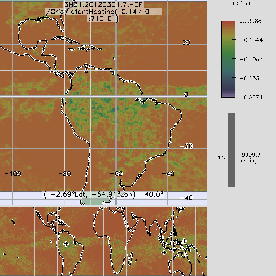
Federal
TRMM TMI/PR Combined Convective Stratiform Heating L3 1 month 0.5 degree x 0.5 degree V7 (TRMM_3H31) at GES DISC recent views
National Aeronautics and Space Administration —
3H31, "Monthly Convective Stratiform Heating from Combined", produces 0.5 deg x 0.5 deg monthly apparent heating profiles from surface convective rainfall rate and... -
Federal
GPM DPR and GMI Combined Convective Stratiform Heating L3 1 month 0.5 degree x 0.5 degree V07 (GPM_3HCSH) at GES DISC recent views
National Aeronautics and Space Administration —
The Gridded Convective Stratiform Heating (3HCSH) products contain latent heating, Q1-QR and Q2 profiles from DPR raindata. Version 07 is the current version of the...

Official websites use .gov
A
.gov website belongs to an official government
organization in the United States.
Secure .gov websites use HTTPS
A
lock (
) or https:// means you’ve safely connected to
the .gov website. Share sensitive information only on official,
secure websites.