
-
Federal
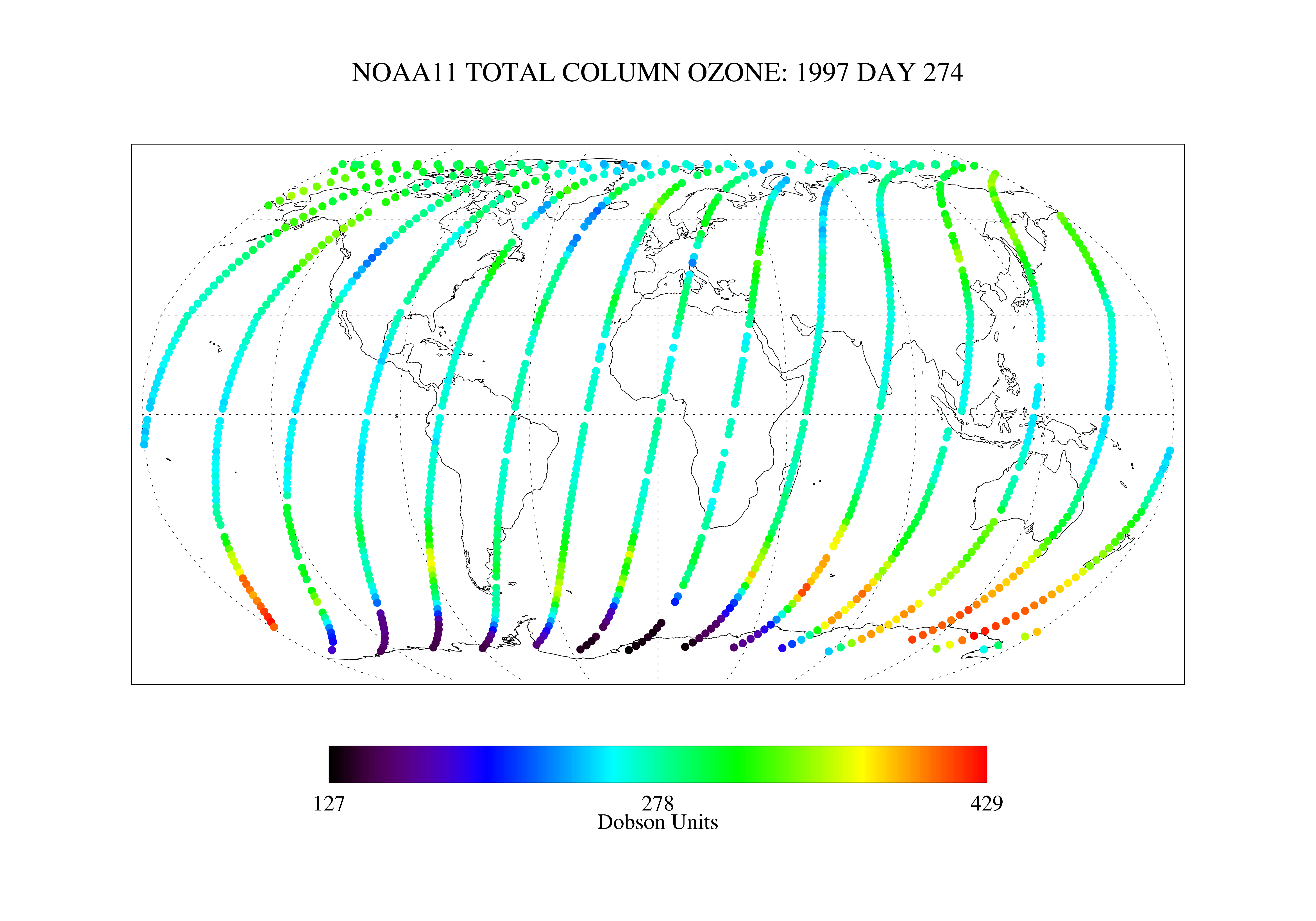
SBUV2/NOAA-11 Ozone (O3) Nadir Profile and Total Column 1 Day L2 V1 (SBUV2N11L2) at GES DISC recent views
National Aeronautics and Space Administration —
The Solar Backscattered Ultraviolet (SBUV) from NOAA-11 Level-2 daily product (SBUV2N11L2) contains ozone nadir profile and total column data from retrievals... -
Federal
Hurricane Gustav Poster recent views
National Oceanic and Atmospheric Administration, Department of Commerce —
Hurricane Gustav poster. Multi-spectral image from NOAA-17 shows Hurricane Gustav having made landfall along the Louisiana coastline. Poster size is 36"x27" -
Federal
Earth Radiation Budget Experiment (ERBE) S-4G Nonscanner,Medium Field of View (MFOV) Numerical Filter (NF) Zonal and Global Averages in HDF recent views
National Aeronautics and Space Administration —
ERBE_S4G_MFOV_NF_ZG_1 is the Earth Radiation Budget Experiment (ERBE) S-4G Non-scanner, Medium Field of View (MFOV) Numerical Filter (NF) Zonal and Global Averages in... -
Federal
GPM DPR Ku Precipitation Profile 2A 1.5 hours 5 km V07 (GPM_2AKu) at GES DISC recent views
National Aeronautics and Space Administration —
Version 07 is the current version of the data set. Older versions will no longer be available and have been superseded by Version 07. The 2AKu algorithm is a single-... -
Federal
Tower Winds - Cape Kennedy recent views
National Oceanic and Atmospheric Administration, Department of Commerce —
Digitized data taken from Wind Gust Charts. Record contains hourly wind directions and speed with a peak wind recorded at the end of each day. Sorted by: station,... -
Federal
S-MODE DopplerScatt Level 2 Ocean Winds and Currents Version 2 recent views
National Aeronautics and Space Administration —
This dataset contains concurrent airborne DopplerScatt radar retrievals of surface vector winds and ocean currents from the Sub-Mesoscale Ocean Dynamics Experiment... -
Federal
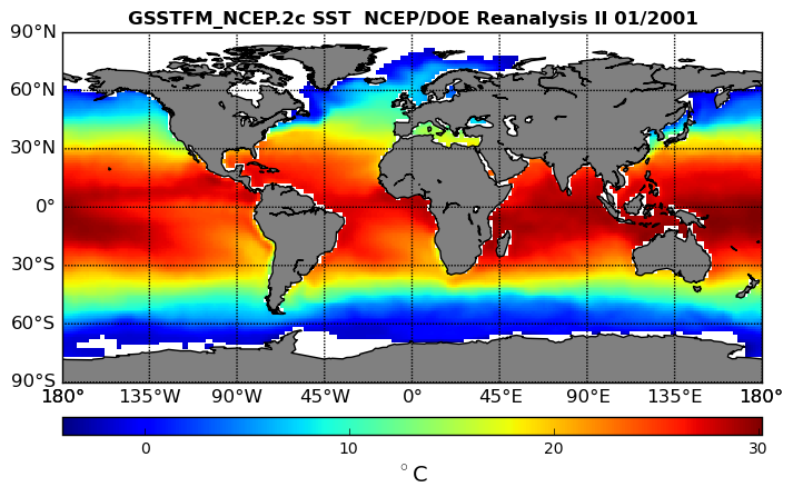
NCEP/DOE Reanalysis II in HDF-EOS5, for GSSTF2c, 1x1 deg Monthly grid V2c (GSSTFM_NCEP) at GES DISC recent views
National Aeronautics and Space Administration —
These data are the Goddard Satellite-based Surface Turbulent Fluxes Version-2c Dataset recently produced through a MEaSURES funded project led by Dr. Chung-Lin Shie... -
Federal
Northeast Snowfall Impact Scale (NESIS) recent views
National Oceanic and Atmospheric Administration, Department of Commerce —
While the Fujita and Saffir-Simpson Scales characterize tornadoes and hurricanes respectively, there is no widely used scale to classify snowstorms. The Northeast... -
Federal
KORUS-AQ DC-8 Aircraft In Situ Cloud Data recent views
National Aeronautics and Space Administration —
KORUSAQ_Cloud_AircraftInSitu_DC8_Data are in-situ cloud measurements collected onboard the DC-8 aircraft during the KORUS-AQ field campaign. This product features... -
Federal
GPM SSMI on F14 (GPROF) Climate-based Radiometer Precipitation Profiling L3 1 month 0.25 degree x 0.25 degree V07 (GPM_3GPROFF14SSMI_CLIM) at GES DISC recent views
National Aeronautics and Space Administration —
Version 07 is the current version of the data set. Older versions will no longer be available and have been superseded by Version 07. The "CLIM" products differ from... -
Federal
BOREAS AFM-03 Electra 1994 Aircraft Flux and Moving Window Data recent views
National Aeronautics and Space Administration —
Measurements of the fluxes of momentum, sensible and latent heat, carbon dioxide, and ozone over the entire BOREAS region to tie together measurements made in both... -
Federal
NMFS Bottom Longline Analytical Dataset Provided to NRDA (NCEI Accession 0147683) recent views
National Oceanic and Atmospheric Administration, Department of Commerce —
The Southeast Fisheries Science Center Mississippi Laboratories has conducted standardized bottom longline surveys in the Gulf of Mexico and South Atlantic since... -
Federal
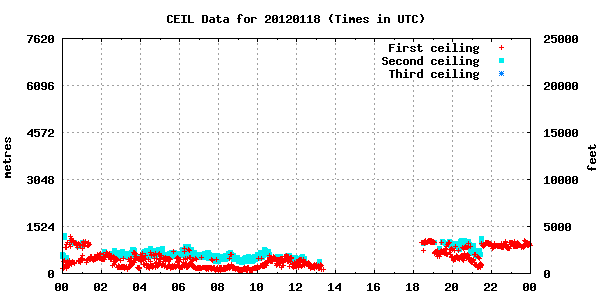
GPM GROUND VALIDATION ENVIRONMENT CANADA (EC) VAISALA CEILOMETER GCPEX V1 recent views
National Aeronautics and Space Administration —
The GPM Ground Validation Environment Canada (EC) VAISALA Ceilometer GCPEx dataset was collected during the GPM Cold-season Precipitation Experiment (GCPEx) in... -
Federal
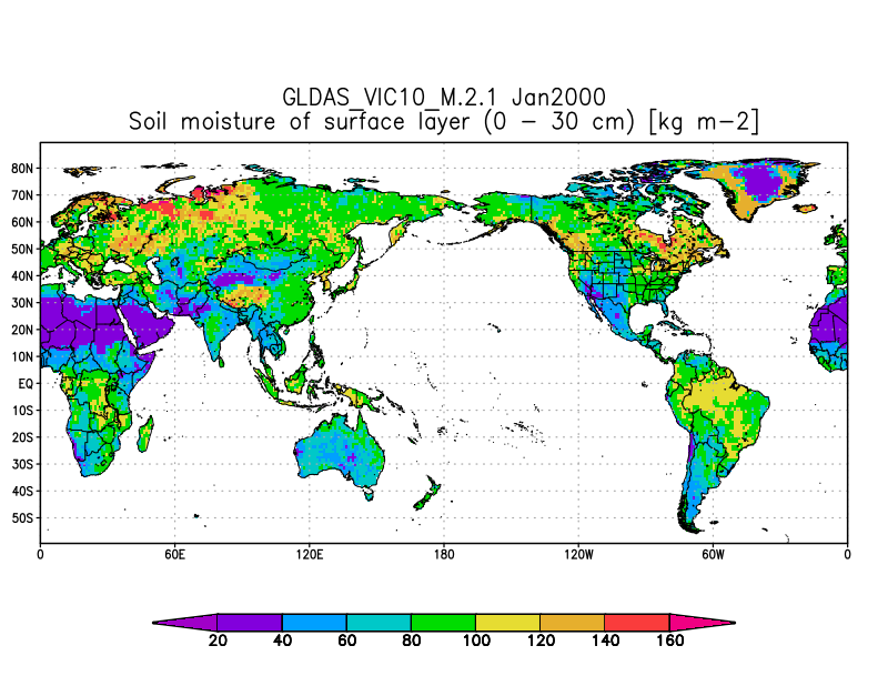
GLDAS VIC Land Surface Model L4 monthly 1.0 x 1.0 degree V2.1 (GLDAS_VIC10_M) at GES DISC recent views
National Aeronautics and Space Administration —
NASA Global Land Data Assimilation System Version 2 (GLDAS-2) has three components: GLDAS-2.0, GLDAS-2.1, and GLDAS-2.2. GLDAS-2.0 is forced entirely with the... -
Federal
BOREAS/AES Campbell Scientific 15-minute Surface Meteorological Data: 1993 recent views
National Aeronautics and Space Administration —
Contains data from 1993 from the Atmospheric Environment Service Campbell Scientific autostations collecting continuous fifteen minute data for BOREAS. -
Federal
BOREAS/AES Campbell Scientific 15-minute Surface Meteorological Data: 1996 recent views
National Aeronautics and Space Administration —
Contains data from 1996 from the Atmospheric Environment Service Campbell Scientific autostations collecting continuous fifteen minute data for BOREAS. -
Federal
BOREAS HYD-09 Hourly and Daily Radar Rainfall Maps for the Southern Study Area recent views
National Aeronautics and Space Administration —
The BOREAS HYD-09 team collected data on precipitation and streamflow over portions of the NSA and SSA. This data set contains Cartesian maps of rain accumulation for... -
Federal
First ISCCP Regional Experiment (FIRE) Atlantic Stratocumulus Transition Experiment (ASTEX) MAGE Oceanus Sulfur in the Air Data recent views
National Aeronautics and Space Administration —
The First ISCCP Regional Experiments have been designed to improve data products and cloud/radiation parameterizations used in general circulation models (GCMs).... -
Federal
S-MODE NCOM Model Output Version 1 recent views
National Aeronautics and Space Administration —
This dataset contains model output from the Navy Coastal Ocean Model (NCOM) run during the Sub-Mesoscale Ocean Dynamics Experiment (S-MODE) field campaign. S-MODE... -
Federal
Hurricane Isabel Poster (September 18, 2003) recent views
National Oceanic and Atmospheric Administration, Department of Commerce —
Hurricane Isabel poster. Multi-spectral image from NOAA-17 shows Hurricane Isabel making landfall on the North Carolina Outer Banks on September 18, 2003. Poster...

Official websites use .gov
A
.gov website belongs to an official government
organization in the United States.
Secure .gov websites use HTTPS
A
lock (
) or https:// means you’ve safely connected to
the .gov website. Share sensitive information only on official,
secure websites.