
-
Federal
GPCP Precipitation Level 3 Daily 0.5-Degree V3.2 (GPCPDAY) at GES DISC recent views
National Aeronautics and Space Administration —
Version 3.2 is the current version. Older versions have been superseded by Version 3.2. The Global Precipitation Climatology Project (GPCP) is the precipitation... -
Federal
Quality Controlled Lightning Imaging Sensor (LIS) on International Space Station (ISS) Backgrounds V2 recent views
National Aeronautics and Space Administration —
The Quality Controlled Lightning Imaging Sensor (LIS) on International Space Station (ISS) Backgrounds dataset was collected by the LIS instrument mounted on the ISS... -
Federal
Annual Summary of Artificial Light At Night from VIIRS/S-NPP at CONUS County and Census Tract V1 (ALAN_VIIRS_CONUS) at GES DISC recent views
National Aeronautics and Space Administration —
This product provides detailed information about the satellite-based data on artificial light at night (ALAN). The Suomi National Polar-orbiting Partnership (S-NPP)... -
Federal
NLDAS Noah Land Surface Model L4 Monthly 0.125 x 0.125 degree V2.0 (NLDAS_NOAH0125_M) at GES DISC recent views
National Aeronautics and Space Administration —
This data set contains fifty-two fields simulated from the Noah land-surface model (LSM) for Phase 2 of the North American Land Data Assimilation System (NLDAS-2).... -
Federal
Comprehensive Ocean - Atmosphere Data Set (COADS) LMRF Arctic Subset, 1950 - 1995, Version 1 recent views
National Aeronautics and Space Administration —
The Comprehensive Ocean - Atmosphere Data Set (COADS) Long Marine Reports Fixed-Length (LMRF) Arctic subset contains marine surface weather reports for regions north... -
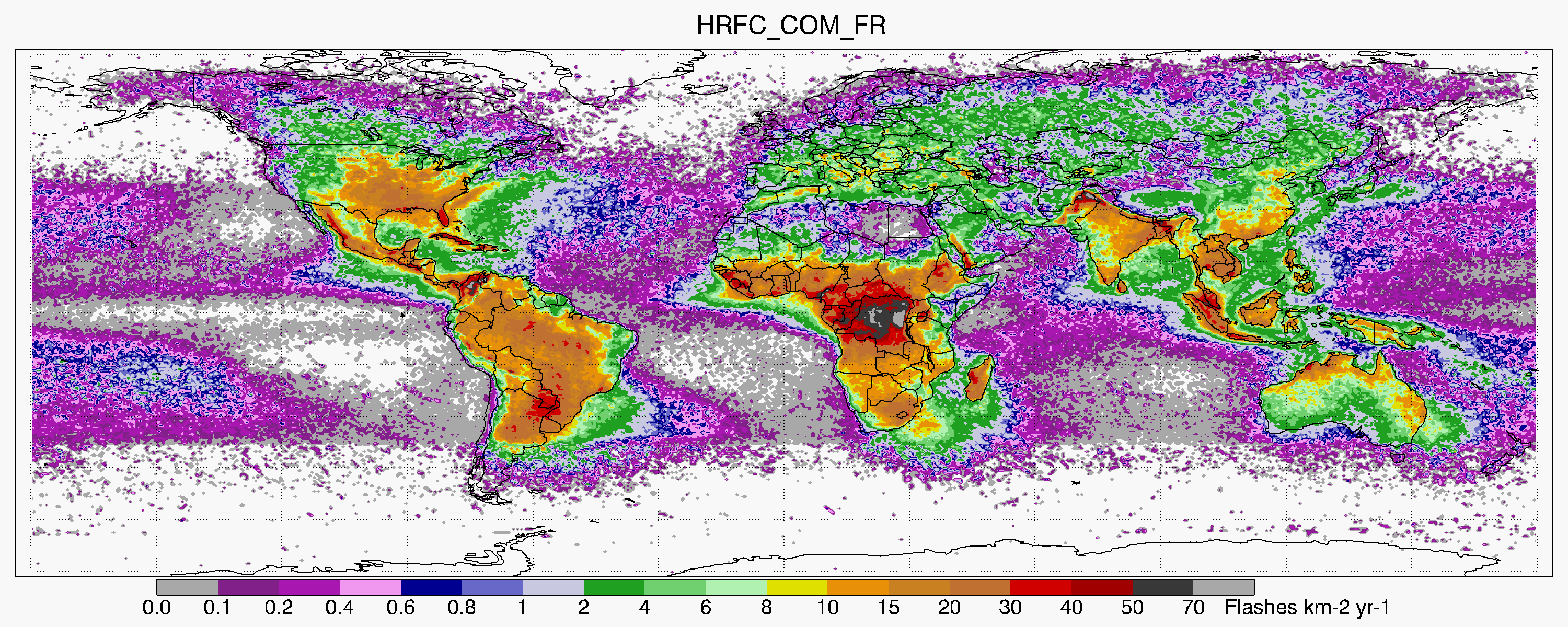
Federal
LIS/OTD 0.5 Degree High Resolution Full Climatology (HRFC) V2.3.2015 recent views
National Aeronautics and Space Administration —
The LIS/OTD 0.5 Degree High Resolution Full Climatology (HRFC) contains a variety of gridded climatologies of total lightning flash rates obtained from two lightning... -
Federal
ISLSCP II EDGAR 3 Gridded Greenhouse and Ozone Precursor Gas Emissions recent views
National Aeronautics and Space Administration —
The EDGAR (Emission Database for Global Atmospheric Research) database project is a comprehensive task carried out jointly by the National Institute for Public Health... -
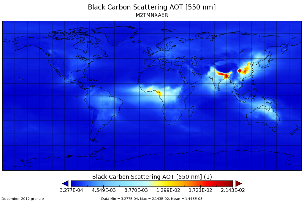
Federal
MERRA-2 tavgM_2d_aer_Nx: 2d,Monthly mean,Time-averaged,Single-Level,Assimilation,Aerosol Diagnostics 0.625 x 0.5 degree V5.12.4 (M2TMNXAER) at GES DISC recent views
National Aeronautics and Space Administration —
M2TMNXAER (or tavgM_2d_aer_Nx) is a time-averaged 2-dimensional monthly mean data collection in Modern-Era Retrospective analysis for Research and Applications... -
Federal
NLDAS Secondary Forcing Data L4 Hourly 0.125 x 0.125 degree V2.0 (NLDAS_FORB0125_H) at GES DISC recent views
National Aeronautics and Space Administration —
This data set contains the secondary forcing hourly data "File B" for Phase 2 of the North American Land Data Assimilation System (NLDAS-2). The data are in 1/8th... -
Federal
GPM IMERG Early Precipitation L3 1 day 0.1 degree x 0.1 degree V06 (GPM_3IMERGDE) at GES DISC recent views
National Aeronautics and Space Administration —
The Integrated Multi-satellitE Retrievals for GPM (IMERG) is the unified U.S. algorithm that provides the multi-satellite precipitation product for the U.S. GPM team.... -
Federal
GLDAS Catchment Land Surface Model L4 daily 0.25 x 0.25 degree GRACE-DA1 V2.2 (GLDAS_CLSM025_DA1_D) at GES DISC recent views
National Aeronautics and Space Administration —
NASA Global Land Data Assimilation System Version 2 (GLDAS-2) has three components: GLDAS-2.0, GLDAS-2.1, and GLDAS-2.2. GLDAS-2.0 is forced entirely with the... -
Federal
MODIS/Terra Cloud Mask and Spectral Test Results 5-Min L2 Swath 250m and 1km - NRT NGDA recent views
National Aeronautics and Space Administration —
The MODIS level-2 cloud mask product is a global product generated for both daytime and nighttime conditions at 1-km spatial resolution (at nadir) and for daytime at... -
Federal
MISR L2 TOA/Cloud Stereo Product subset for the INTEX-B region V002 recent views
National Aeronautics and Space Administration —
MISR Level 2 TOA/Cloud Stereo Product containing the Stereoscopically Derived Cloud Mask (SDCM), cloud winds, Reflecting Level Reference Altitude (RLRA), with... -
Federal
CALIPSO Lidar Level 1B profile data, V4-10 recent views
National Aeronautics and Space Administration —
CAL_LID_L1-Standard-V4-10 is the Cloud-Aerosol Lidar and Infrared Pathfinder Satellite Observation (CALIPSO) Lidar Level 1B profile data, Version 4-10 data product.... -
Federal
MERRA-2 inst6_3d_ana_Nv: 3d,6-Hourly,Instantaneous,Model-Level,Analysis,Analyzed Meteorological Fields 0.625 x 0.5 degree V5.12.4 (M2I6NVANA) at GES DISC recent views
National Aeronautics and Space Administration —
M2I6NVANA (or inst6_3d_ana_Nv) is an instantaneous 3-dimensional 6-hourly data collection in Modern-Era Retrospective analysis for Research and Applications version 2... -
Federal
MODIS/Terra Total Precipitable Water Vapor 5-Min L2 Swath 1km and 5km - NRT NGDA recent views
National Aeronautics and Space Administration —
The MODIS Adaptive Processing System (MODAPS) is currently generating an improved Collection 6.1 (061) for all MODIS Level-1 (L1) and higher-level Level-2 (L2) &... -
Federal
Daily and Annual PM2.5, O3, and NO2 Concentrations at ZIP Codes for the Contiguous U.S., 2000-2016, v1.0 recent views
National Aeronautics and Space Administration —
The Daily and Annual PM2.5, O3, and NO2 Concentrations at ZIP Codes for the Contiguous U.S., 2000-2016, v1.0 data set contains daily and annual concentration... -
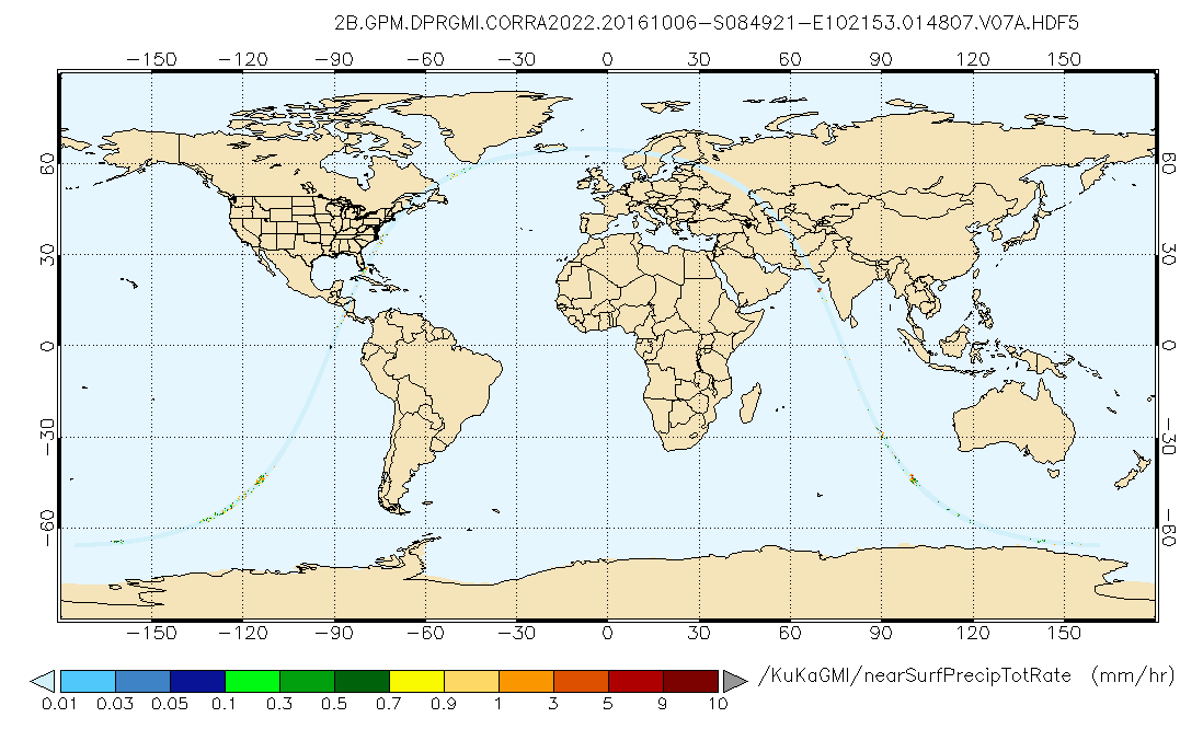
Federal
GPM DPR and GMI Combined Precipitation L2B 1.5 hours 5 km V07 (GPM_2BCMB) at GES DISC recent views
National Aeronautics and Space Administration —
Version 07 is the current version of the data set. Older versions will no longer be available and have been superseded by Version 07. This is a precipitation product... -
Federal
MERRA-2 tavg1_2d_aer_Nx: 2d,1-Hourly,Time-averaged,Single-Level,Assimilation,Aerosol Diagnostics 0.625 x 0.5 degree V5.12.4 (M2T1NXAER) at GES DISC recent views
National Aeronautics and Space Administration —
M2T1NXAER (or tavg1_2d_aer_Nx) is an hourly time-averaged 2-dimensional data collection in Modern-Era Retrospective analysis for Research and Applications version 2... -
Federal
FLDAS Noah Land Surface Model L4 Global Monthly 0.1 x 0.1 degree (MERRA-2 and CHIRPS) V001 (FLDAS_NOAH01_C_GL_M) at GES DISC recent views
National Aeronautics and Space Administration —
This dataset contains a series of land surface parameters simulated from the Noah 3.6.1 model in the Famine Early Warning Systems Network (FEWS NET) Land Data...

Official websites use .gov
A
.gov website belongs to an official government
organization in the United States.
Secure .gov websites use HTTPS
A
lock (
) or https:// means you’ve safely connected to
the .gov website. Share sensitive information only on official,
secure websites.