
-
Federal
NACP North American Forest Dynamics Project: Forest Disturbance and Regrowth Data recent views
National Aeronautics and Space Administration —
This data set provides the results of time-series analyses of Landsat imagery for 55 selected forested sites across the conterminous U.S.A. The output is a pair of... -
Federal
Declassified Satellite Imagery 2 (2002) recent views
National Aeronautics and Space Administration —
Declassified satellite images provide an important worldwide record of land-surface change. With the success of the first release of classified satellite photography... -
Federal
CEOS Cal Val Test Site - Ivanpah Playa, USA - Instrumented Site NGDA recent views
National Aeronautics and Space Administration —
On the background of these requirements for sensor calibration, intercalibration and product validation, the subgroup on Calibration and Validation of the Committee... -
Federal
GLDAS Catchment Land Surface Model L4 daily 0.25 x 0.25 degree GRACE-DA1 V2.2 (GLDAS_CLSM025_DA1_D) at GES DISC recent views
National Aeronautics and Space Administration —
NASA Global Land Data Assimilation System Version 2 (GLDAS-2) has three components: GLDAS-2.0, GLDAS-2.1, and GLDAS-2.2. GLDAS-2.0 is forced entirely with the... -
Federal
NACP Integrated Wildland and Cropland 30-m Fuel Characteristics Map, U.S.A., 2010 recent views
National Aeronautics and Space Administration —
The data set provides a 30-m comprehensive fuelbed characteristics map for both the wildland and cropland areas of the conterminous United States (CONUS) for 2010.... -
Federal
CERES Monthly Gridded Radiative Fluxes and Clouds Terra FM1 Edition2F recent views
National Aeronautics and Space Administration —
CER_FSW_Terra-FM1-MODIS_Edition2F is the Clouds and the Earth's Radiant Energy System (CERES) Monthly Gridded Radiative Fluxes and Clouds Terra Flight Model 1 (FM1)... -
Federal
Rock glaciers, Upper Engadin, Switzerland, Version 1 recent views
National Aeronautics and Space Administration —
The investigated region is called Upper Engadin and is situated in the Eastern part of the Swiss Alps. The area is characterized by a high situated valley floor with... -
Federal
Landscape Map of the Russian Arctic Coastal Zone, Version 1 recent views
National Aeronautics and Space Administration —
The map consists of ESRI Shapefiles of landscape polygons (in landscape unit types) for the Russian Arctic coastal zone (scale 1:4,000,000). The map is based on a... -
Federal
MISR Level 2 Surface parameters V002 recent views
National Aeronautics and Space Administration —
MIL2ASLS_2 is the Multi-angle Imaging SpectroRadiometer (MISR) Level 2 Land Surface parameters version 2 data product. It contains a variety of information on the... -
Federal
MISR Level 3 Component Global Land Product covering a year V004 recent views
National Aeronautics and Space Administration —
MIL3YLS_4 is the Multi-angle Imaging SpectroRadiometer (MISR) Level 3 Component Global Land Product covering a year version 4. It contains a statistical summary of... -
Federal
EMIT L2B Estimated Mineral Identification and Band Depth and Uncertainty 60 m V001 recent views
National Aeronautics and Space Administration —
The Earth Surface Mineral Dust Source Investigation (EMIT) instrument measures surface mineralogy, targeting the Earth’s arid dust source regions. EMIT is installed... -
Federal
Siberian Boreal Forest Aboveground Biomass and Fire Scar Maps, Russia, 1969-2007 NGDA recent views
National Aeronautics and Space Administration —
This data set provides 30-meter resolution mapped estimates of Cajander larch (Larix cajanderi) aboveground biomass (AGB), circa 2007, and a map of burn perimeters... -
Federal
TES/Aura L2 Ancillary Special Observation Product V007 recent views
National Aeronautics and Space Administration —
TL2ANCS_7 is the Tropospheric Emission Spectrometer (TES)/Aura Level 2 Ancillary Special Observation Product Version 7 data product. TES was an instrument aboard... -
Federal
Arctic Vegetation Plots at Toolik Lake, Alaska, 1989 recent views
National Aeronautics and Space Administration —
This dataset provides environmental, soil, and vegetation data collected in August 1989 from 81 study plots at the Toolik Lake research site, located in the southern... -
Federal
MODIS/Aqua Surface Reflectance Daily L2G Global 500m SIN Grid NRT NGDA recent views
National Aeronautics and Space Administration —
The MODIS/Aqua Surface Reflectance Daily L2G Global 500m SIN Grid Near Real Time (NRT) product, short name MYD09GHK, is a seven-band product computed from the MODIS... -
Federal
MISR Level 3 Component Global Land Regional public Product covering a day V002 recent views
National Aeronautics and Space Administration —
MI3DLSR_2 is the Multi-angle Imaging SpectroRadiometer (MISR) Level 3 Component Global Land Regional public Product covering a dayversion 2. It contains a daily... -
Federal
ABoVE: Reflectance Spectra of Tundra Plant Communities across Northern Alaska recent views
National Aeronautics and Space Administration —
This dataset reports full-spectrum (350-2500 nm) reflectance measurements of diverse plant communities at the plot-level and individual plant species at the leaf-... -
Federal
MERRA-2 tavgM_2d_rad_Nx: 2d,Monthly mean,Time-Averaged,Single-Level,Assimilation,Radiation Diagnostics 0.625 x 0.5 degree V5.12.4 (M2TMNXRAD) at GES DISC recent views
National Aeronautics and Space Administration —
M2TMNXRAD (or tavgM_2d_rad_Nx) is a time-averaged 2-dimensional monthly mean data collection in Modern-Era Retrospective analysis for Research and Applications... -
Federal
VIIRS/NPP Land Surface Temperature/Emissivity Monthly L3 Global 0.05Deg CMG V002 recent views
National Aeronautics and Space Administration —
The NASA/NOAA Suomi National Polar-orbiting Partnership (Suomi NPP) Visible Infrared Imaging Radiometer Suite (VIIRS)... -
Federal
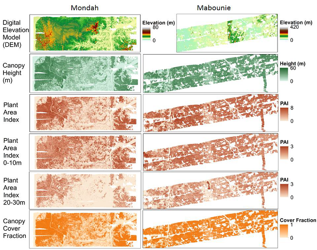
AfriSAR: Gridded Forest Biomass and Canopy Metrics Derived from LVIS, Gabon, 2016 recent views
National Aeronautics and Space Administration —
This dataset contains gridded forest characterization products derived from full-waveform lidar data acquired by NASA's airborne Land, Vegetation, and Ice Sensor...

Official websites use .gov
A
.gov website belongs to an official government
organization in the United States.
Secure .gov websites use HTTPS
A
lock (
) or https:// means you’ve safely connected to
the .gov website. Share sensitive information only on official,
secure websites.