
-
Federal
Mercury Map Catalog recent views
National Aeronautics and Space Administration —
The Mercury Map Catalog includes various mappings of the surface of Mercury published by the U.S. Geological Survey from 1976 - 1990. -
Federal
Goddard Earth Sciences Data and Information Services Center (GES DISC) recent views
National Aeronautics and Space Administration —
The NASA Goddard Earth Sciences (GES) Data and Information Services Center (DISC) is the home (archive) of Precipitation, Atmospheric Chemistry and Dynamics, and... -
Federal
NASA Technical Reports Server (NTRS) recent views
National Aeronautics and Space Administration —
The NTRS is a valuable resource for researchers, students, educators, and the public to access NASA's current and historical technical literature and engineering... -
Federal
NASA/IPAC Infrared Science Archive recent views
National Aeronautics and Space Administration —
IRSA is chartered to curate the calibrated science products from NASAs infrared and sub-millimeter missions, including five major large-area/all-sky surveys. IRSA... -
Federal
Earth Resources Observation and Science (EROS) Center's Image of the Week Gallery recent views
National Aeronautics and Space Administration —
The Earth Resources Observation and Science (EROS) Center manages the this image of the week gallery. -
Federal
Lunar Core Drive Tubes Summary recent views
National Aeronautics and Space Administration —
Contains a brief summary and high resolution imagery from various lunar rock and core drive tubes collected from the Apollo and Luna missions to the moon. -
Federal
Apollo Image Atlas recent views
National Aeronautics and Space Administration —
The Apollo Image Atlas is a comprehensive collection of Apollo-Saturn mission photography. Included are almost 25,000 lunar images, both from orbit and from the... -
Federal
EPIC Daily Blue Marble API recent views
National Aeronautics and Space Administration —
This is an API for the Earth Polychromatic Imaging Camera. -
Federal
Lunar Sample Atlas recent views
National Aeronautics and Space Administration —
The Lunar Sample Atlas provides pictures of the Apollo samples taken in the Lunar Sample Laboratory, full-color views of the samples in microscopic thin-sections,... -
Federal
Apollo Surface Panoramas recent views
National Aeronautics and Space Administration —
Apollo Surface Panoramas is a digital library of photographic panoramas that the Apollo astronauts took while exploring the Moon's surface. These images provide a... -
Federal
Gazetteer of Planetary Nomenclature: Asteroids: Lutetia Regions recent views
National Aeronautics and Space Administration —
These images display asteriods documented and approved by the International Astronomical Union (IAU). -
Federal
Gazetteer of Planetary Nomenclature: Saturnian System: Enceladus recent views
National Aeronautics and Space Administration —
These images display several of Saturn's moons approved by the International Astronomical Union (IAU). -
Federal
Gazetteer of Planetary Nomenclature: Jovian System: Ganymede recent views
National Aeronautics and Space Administration —
These images display several of Jupiter's moons approved by the International Astronomical Union (IAU). -
Federal
Earth Imagery API recent views
National Aeronautics and Space Administration —
The API is powered by Google Earth Engine, and currently only supports pan-sharpened Landsat 8 imagery. -
Federal
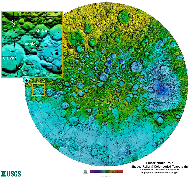
Gazetteer of Planetary Nomenclature: Moon: 1:10 million-scale Shaded Relief and Color-coded Topography: North Pole recent views
National Aeronautics and Space Administration —
These lunar maps display the four different areas of the moon with color-coded topography in low and high resolution approved by the International Astronomical Union... -
Federal
Gazetteer of Planetary Nomenclature: Moon: 1:1 million-scale maps of the Moon recent views
National Aeronautics and Space Administration —
The purpose of the lunar maps is to provide an up-to-date and comprehensive depiction on lunar nomenclature approved by the International Astronomical Union (IAU). -
Federal
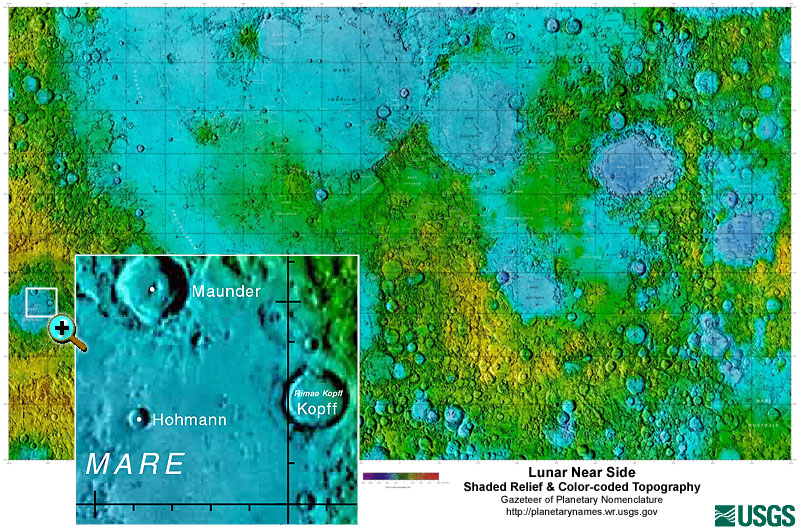
Gazetteer of Planetary Nomenclature: Moon: 1:10 million-scale Shaded Relief and Color-coded Topography: Near Side recent views
National Aeronautics and Space Administration —
These lunar maps display the four different areas of the moon with color-coded topography in low and high resolution approved by the International Astronomical Union... -
Federal
Gazetteer of Planetary Nomenclature: Moon: 1:10 million-scale Shaded Relief and Color-coded Topography: South Pole recent views
National Aeronautics and Space Administration —
These lunar maps display the four different areas of the moon with color-coded topography in low and high resolution approved by the International Astronomical Union... -
Federal
Gazetteer of Planetary Nomenclature: Mercury: 1:5 million-scale recent views
National Aeronautics and Space Administration —
The purpose of this set of maps is to provide an up-to-date source showing the locations of Mercury surface feature names approved by the International Astronomical...

Official websites use .gov
A
.gov website belongs to an official government
organization in the United States.
Secure .gov websites use HTTPS
A
lock (
) or https:// means you’ve safely connected to
the .gov website. Share sensitive information only on official,
secure websites.