
-
Federal
Aboveground Biomass, Landcover, and Degradation, Kalimantan Forests, Indonesia, 2014
National Aeronautics and Space Administration —
This dataset provides estimates of aboveground biomass, percent canopy cover, mean canopy height, landcover, and forest degradation index products for forests in... -
Federal
Global 1-km Gridded Thickness of Soil, Regolith, and Sedimentary Deposit Layers
National Aeronautics and Space Administration —
This data set provides high-resolution estimates of the thickness of the permeable layers above bedrock (soil, regolith, and sedimentary deposits) within a global... -
Federal
Global Soil Types, 1-Degree Grid (Zobler)
National Aeronautics and Space Administration —
A global data set of soil types is available at 1-degree latitude by 1-degree longitude resolution. There are 26 soil units based on Zobler?s assessment of FAO Soil... -
Federal
Pre-Delta-X: Total Suspended Solids of Surface Water across MRD, LA, USA, 2015-2016
National Aeronautics and Space Administration —
This dataset contains the total suspended solids (TSS) concentration of in situ water samples collected at selected sites across the Atchafalaya and Terrebonne Basins... -
Federal
Delta-X: Bed and Suspended Sediment Grain Size, MRD, LA, USA, 2019-2021, V3
National Aeronautics and Space Administration —
This dataset includes sediment concentration and grain size distribution measurements from suspended and bed sediment samples collected in the Atchafalaya River and... -
Federal
ABoVE: Riverbank Erosion and Vegetation Changes, Yukon River Basin, Alaska, 1984-2017
National Aeronautics and Space Administration —
This dataset provides a time series of riverbank erosion and vegetation colonization along reaches of the Yukon River (3 study areas), Tanana and Nenana Rivers (1... -
Federal
Delta-X: NUMAR Soil Accretion Modeled to 2100, MRD, Louisiana, USA
National Aeronautics and Space Administration —
This dataset holds modeled estimates of soil accretion for the Atchafalaya and Terrebonne basins in the Mississippi River Delta of coastal Louisiana, U.S. Soil... -
Federal
Delta-X: Soil Accretion Rates from Cs-137 Activity and NUMAR Validation, MRD, LA
National Aeronautics and Space Administration —
This dataset holds measurements of Cesium-137 (137Cs) activity sampled from sites in the Atchafalaya and Terrebonne Basins on the southern coast of Louisiana, USA.... -
Federal
Delta-X: Feldspar Sediment Accretion Measurements, MRD, LA, USA, 2019-2023, Version 4
National Aeronautics and Space Administration —
This dataset provides elevation, hydrogeomorphic zone classification, soil carbon content, bulk density, organic matter content, and sediment accretion measurements... -
Federal
BOREAS TGB-04 Water and Sediment Temperature Data over the NSA-BP (Beaver Pond)
National Aeronautics and Space Administration —
The BOREAS TGB-04 team collected several data sets in support of their flux tower measurements at the NSA Beaver Pond site. This data set contains water and sediment... -
Federal
LBA-ECO LC-07 Lake Sediment Nutrient Data, Lago Calado, Brazil: 1982-1984
National Aeronautics and Space Administration —
This data set reports lake sediment texture and porosity, carbon (C), nitrogen (N), and phosphorus (P) content of surficial sediments, 210Pb-derived nutrient... -
Federal
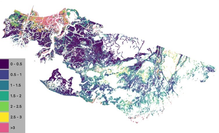
Resilience of Coastal Wetlands to Sea Level Rise, CONUS, 1996-2100
National Aeronautics and Space Administration —
This dataset provides information about the resilience of tidal wetlands to sea-level rise under three scenarios of global change. With rising seas, regularly... -
Federal
Tidal Wetlands Soil Organic Carbon and Estuarine Characteristics, USA, 1972-2015
National Aeronautics and Space Administration —
This dataset provides a synthesis of soil organic carbon (SOC) estimates and a variety of other environmental information from tidal wetlands within estuaries in the... -
Federal
Surface Water Elevation and Quality, Peace-Athabasca Delta, Canada, 2006-2007
National Aeronautics and Space Administration —
The Peace-Athabasca Delta (PAD) is a large boreal wetland located in northeastern Alberta, Canada at the confluence of the Peace and Athabasca Rivers with Lake... -
Federal
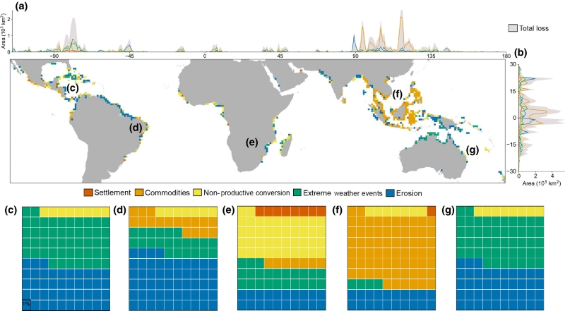
Global Mangrove Loss Extent, Land Cover Change, and Loss Drivers, 2000-2016
National Aeronautics and Space Administration —
This dataset provides estimates of the extent of mangrove loss, land cover change, and its anthropogenic or climatic drivers in three time periods: 2000-2005,... -
Federal
Delta-X: In Situ Water Surface Reflectance across MRD, LA, USA, 2021, V3
National Aeronautics and Space Administration —
This dataset includes above water measurements of remote-sensing reflectance measured in situ at field sampling stations during the Delta-X 2021 field efforts.... -
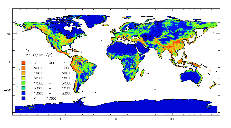
Federal
ISLSCP II Global River Fluxes of Carbon and Sediments to the Oceans
National Aeronautics and Space Administration —
The River Carbon Flux data set represents estimates for the riverine export of carbon and of sediments. This data set includes the amounts of carbon and of sediments... -
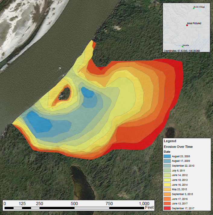
Federal
ABoVE: Annual Thaw Slump Expansion on East Fork Chandalar River, Alaska, 2008-2017
National Aeronautics and Space Administration —
This dataset provides a time series of spatial data showing the expansion of a thaw slump on the East Fork Chandalar River near the community of Venetie, Alaska, from... -
Federal
LBA-ECO LC-07 Methane Releases from Two Amazon Hydroreservoirs, Brazil: 2000-2001
National Aeronautics and Space Administration —
This data set reports methane (CH4) fluxes at the water-air interface and concentrations and isotopic signals of CH4 in the bubbles stirred up from the sediment in...

Official websites use .gov
A
.gov website belongs to an official government
organization in the United States.
Secure .gov websites use HTTPS
A
lock (
) or https:// means you’ve safely connected to
the .gov website. Share sensitive information only on official,
secure websites.