
-
Federal
LiDAR Surveys over Selected Forest Research Sites, Brazilian Amazon, 2008-2018
National Aeronautics and Space Administration —
This dataset provides the complete catalog of point cloud data collected during LiDAR surveys over selected forest research sites across the Amazon rainforest in... -
Federal
NACP Aboveground Biomass and Carbon Baseline Data, V.2 (NBCD 2000), U.S.A., 2000
National Aeronautics and Space Administration —
The NBCD 2000 (National Biomass and Carbon Dataset for the Year 2000) data set provides a high-resolution (30 m) map of year-2000 baseline estimates of basal area-... -
Federal
RLC State and Regional Boundaries for the Former Soviet Union
National Aeronautics and Space Administration —
This data set of state and regional boundaries was derived from the 1:3 million scale administrative boundaries (ESRI, 1998) for the land area of the Former Soviet... -
Federal
LBA Regional Global Historical Climatology Network, V. 1, 1832-1990
National Aeronautics and Space Administration —
This data set consists of a subset of the Global Historical Climatology Network (GHCN) Version 1 database for the study area of the Large Scale Biosphere-Atmosphere... -
Federal
CMS: Forest Carbon Stocks, Emissions, and Net Flux for the Conterminous US: 2005-2010
National Aeronautics and Space Administration —
This data set provides maps of estimated carbon in forests of the 48 continental states of the US for the years 2005-2010. Carbon (termed committed carbon) stocks... -
Federal
LBA-ECO ND-01 Forest and Pasture Soil and Grass Analyses, Rondonia, Brazil: 2003-2004
National Aeronautics and Space Administration —
This data set provides soil physical and chemical properties, and grass nutrient measurements of samples collected from 17 pasture sites located within the state of... -
Federal
Forest Aboveground Biomass and Carbon Sequestration Potential for Maryland, USA.
National Aeronautics and Space Administration —
This dataset provides 90-m resolution maps of estimated forest aboveground biomass (Mg/ha) for nominal year 2011 and projections of carbon sequestration potential for... -
Federal
LBA-ECO CD-06 Ji-Parana River Basin Land Use and Land Cover Map, Brazil: 1999
National Aeronautics and Space Administration —
This data set provides a land use/land cover map of the Ji-Parana River Basin in the state of Rondonia, Brazil produced from the digital classification of eight... -
Federal
LBA-ECO LC-09 Landsat TM and ETM+ Data, Sites in Rondonia and Para, Brazil: 1985-2004
National Aeronautics and Space Administration —
This data set includes 15 zipped archives of rectified .tif format Landsat 5 TM and Landsat 7 ETM+ scenes from near the study sites of Altamira, Santarem, Ponta de... -
Federal
LUH2-ISIMIP2b Harmonized Global Land Use for the Years 2015-2100
National Aeronautics and Space Administration —
This dataset provides 0.25-degree gridded, global, annual estimates of fractional land use and land cover patterns for the period 2015-2100, designed to support the... -
Federal
Carbon Pools across CONUS using the MaxEnt Model, 2005, 2010, 2015, 2016, and 2017
National Aeronautics and Space Administration —
This dataset provides annual estimates of six carbon pools, including forest aboveground live biomass, belowground biomass, aboveground dead biomass, belowground dead... -
Federal
LBA-ECO LC-09 Land Cover Transitions Maps for Study Sites in Para, Brazil: 1970-2001
National Aeronautics and Space Administration —
This data set includes classified land cover transition maps at 30-m resolution derived from Landsat TM, MSS, ETM+ imagery and aerial photos of Altamira, Santarem,... -
Federal
Soil Moisture Profiles and Temperature Data from SoilSCAPE Sites, USA
National Aeronautics and Space Administration —
This data set contains in-situ soil moisture profile and soil temperature data collected at 20-minute intervals at SoilSCAPE (Soil moisture Sensing Controller and... -
Federal
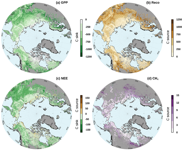
Gridded CO2 and CH4 Flux Estimates for pan-Arctic and Boreal Regions, 2003-2015
National Aeronautics and Space Administration —
This dataset provides gridded estimates of gross primary productivity (GPP), ecosystem respiration (Reco), net ecosystem CO2 exchange (NEE = Reco - GPP), and methane... -
Federal
AirMOSS: L4 Modeled Volumetric Root Zone Soil Moisture, 2012-2015
National Aeronautics and Space Administration —
This data set provides hourly gridded soil moisture estimates derived from hydrologic modeling at nine AirMOSS sites across North America. The AirMOSS L4 RZSM product... -
Federal
LBA-ECO ND-01 Reflectance and Biophysical Measures, Grass Pastures: Rondonia, Brazil
National Aeronautics and Space Administration —
This data set provides the results of spectral reflectance (350 to 2,500 nm at 1-nm increments) and biophysical measurements on grass pastures in eight cattle ranches... -
Federal
LBA-ECO CD-06 Physical, Political, and Hydrologic Maps, Ji-Parana River Basin, Brazil
National Aeronautics and Space Administration —
This data set contains physical, hydrologic, political, demographic, and societal maps for the Ji-Parana River Basin, in the state of Rondonia, Brazil. These data... -
Federal
Forest Aboveground Biomass for Maryland, USA
National Aeronautics and Space Administration —
This dataset includes estimates of annual forest aboveground biomass over the state of Maryland, USA, for the period 1984-2023. It was generated by a modeling...

Official websites use .gov
A
.gov website belongs to an official government
organization in the United States.
Secure .gov websites use HTTPS
A
lock (
) or https:// means you’ve safely connected to
the .gov website. Share sensitive information only on official,
secure websites.