
-
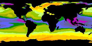
Aquarius Official Release Level 3 Sea Surface Density Standard Mapped Image Ascending Monthly Data V5.0
Aquarius Level 3 sea surface density standard mapped image data contains gridded 1 degree spatial resolution density data averaged over daily, 7 day, monthly, and seasonal time... -
ABoVE: Environmental Conditions and Subsistence Resource Access, Alaska, 2016-2017
This dataset provides descriptions and photos of environmental conditions that impacted availability to subsistence resources by residents in nine rural communities within the... -
Improved Simulations of Biomass Burning Aerosol Optical Properties and Lifetimes during the ORACLES-I Campaign: Results from the NASA GEOS Model
This dataset contains model results and satellite-based research retrievals associated with the manuscript submitted in Atmospheric Chemistry and Physics Journal, titled, "... -
CIDU 2010 paper template
CIDU 2010 LaTeX and Microsoft Word templates. -
Randomized Battery Usage 7: Low-Temperature Left-Skewed Random Walk
This dataset is part of a series of datasets, where batteries are continuously cycled with randomly generated current profiles. Reference charging and discharging cycles are... -
Randomized Battery Usage 1: Random Walk
This dataset is part of a series of datasets, where batteries are continuously cycled with randomly generated current profiles. Reference charging and discharging cycles are... -
FLTz
This data set is a simulated data set based on the flight simulator "FLTz" used by the Intelligent Flight Control (IFC) group at NASA ARC. Flights were preprogrammed to fly... -
Ames Quantum Chemistry
Ames Quantum Chemistry Dataset collects electronic structure, reaction kinetics, and dynamics data calculated at Ames Research Center. This includes potential energy curves and... -
Aquarius Official Release Level 3 Sea Surface Density Standard Mapped Image Ascending Daily Data V5.0
Aquarius Level 3 sea surface density standard mapped image data contains gridded 1 degree spatial resolution density data averaged over daily, 7 day, monthly, and seasonal time... -
Flight Data For Tail 685
The following zip files contain individual flight recorded data in Matlab file format. There are 186 parameters each with a data structure that contains the following: -sensor... -
HIRENASD coarse structured grid
blockstructured hexahedral grid, 6.7 mio elements, 24 degree minimum grid angle, CGNS format version 2.4, double precision Binary, Plot3D file Please contact Thorsten Hansen for... -
BOREAS Scanning Lidar Imager of Canopies by Echo Recovery (SLICER): Level-3 Data
Scanning Lidar Imager of Canopies by Echo Recovery (SLICER) data were acquired in support of BOReal Ecosystem-Atmosphere Study (BOREAS) at all of the Tower Flux (TF) sites in... -
Flight Data For Tail 673
The following zip files contain individual flight recorded data in Matlab file format. There are 186 parameters each with a data structure that contains the following: -sensor... -
Meteorites Cp(T)
07/19/2021 Version 1 Specific Heat Capacity Measurements of Selected Meteorites for Planetary Surface Temperature Modeling Sylvain Piqueux 1, Tuan H. Vu 1, Jonathan Bapst 1,... -
CERES and GEO-Enhanced TOA, Within-Atmosphere and Surface Fluxes, Clouds and Aerosols Monthly Terra-Aqua Edition4A NGDA
CER_SYN1deg-Month_Terra-Aqua-MODIS_Edition4A is the Clouds and the Earth's Radiant Energy System (CERES) and geostationary (GEO)-Enhanced Top of Atmosphere (TOA), Within-... -
Flight Data For Tail 680
The following zip files contain individual flight recorded data in Matlab file format. There are 186 parameters each with a data structure that contains the following: -sensor... -
Flight Data For Tail 683
The following zip files contain individual flight recorded data in Matlab file format. There are 186 parameters each with a data structure that contains the following: -sensor...

Official websites use .gov
A
.gov website belongs to an official government
organization in the United States.
Secure .gov websites use HTTPS
A
lock (
) or https:// means you’ve safely connected to
the .gov website. Share sensitive information only on official,
secure websites.