
-
ASTER Global DEM NGDA 10 recent views
ASTER is capable of collecting in-track stereo using nadir- and aft-looking near infrared cameras. Since 2001, these stereo pairs have been used to produce single-scene (60- x... -
ASTER Digital Elevation Model V003 NGDA
The ASTER Digital Elevation Model (AST14DEM) product is generated (https://lpdaac.usgs.gov/documents/996/ASTER_Earthdata_Search_Order_Instructions.pdf) using bands 3N (nadir-... -
ASTER Global Digital Elevation Model V003 NGDA
The ASTER Global Digital Elevation Model (GDEM) Version 3 (ASTGTM) provides a global digital elevation model (DEM) of land areas on Earth at a spatial resolution of 1 arc second... -
MODIS/Aqua Water Reservoir Monthly L3 Global V061 NGDA
The Aqua Moderate Resolution Imaging Spectroradiometer (MODIS) Water Reservoir Monthly Level 3 (L3) Global (MYD28C3) Version 6.1 product provides current data for 151 man-made... -
Siberian Boreal Forest Aboveground Biomass and Fire Scar Maps, Russia, 1969-2007 NGDA
This data set provides 30-meter resolution mapped estimates of Cajander larch (Larix cajanderi) aboveground biomass (AGB), circa 2007, and a map of burn perimeters for 116... -
MODIS/Terra Water Reservoir 8-Day L3 Global V061 NGDA
The Terra Moderate Resolution Imaging Spectroradiometer (MODIS) Water Reservoir 8-Day Level 3 (L3) Global (MOD28C2) Version 6.1 product provides current data for 151 man-made... -
ASTER Global Digital Elevation Model Attributes NetCDF V003 NGDA
The ASTER Global Digital Elevation Model (GDEM) Version 3 (ASTGTM) provides a global digital elevation model (DEM) of land areas on Earth at a spatial resolution of 1 arc second... -
ASTER Global Water Bodies Database NetCDF V001 NGDA
The ASTER Global Water Bodies Database (ASTWBD) Version 1 data product provides global coverage of water bodies larger than 0.2 square kilometers at a spatial resolution of 1... -
MODIS/Aqua Water Reservoir 8-Day L3 Global V061 NGDA
The Aqua Moderate Resolution Imaging Spectroradiometer (MODIS) Water Reservoir 8-Day Level 3 (L3) Global (MYD28C2) Version 6.1 product provides current data for 151 man-made... -
ASTER Global Water Bodies Database Attributes NetCDF V001 NGDA
The ASTER Global Water Bodies Database (ASTWBD) Version 1 data product provides global coverage of water bodies larger than 0.2 square kilometers at a spatial resolution of 1... -
ABoVE: Dall Sheep Response to Snow and Landscape Covariates, Alaska, 2005-2008 NGDA
This dataset provides daily estimates of snow depth and snow density for the study area in Lake Clark National Park and Preserve (LCNPP), Alaska. The data were generated using... -
MODIS/Aqua Geolocation Fields 1km 5-Min 1A Narrow Swath Subset along CloudSat V002 (MAC03S0) at GES DISC NGDA
This is the narrow-swath MODIS/Aqua subset along CloudSat field of view track. The goal of the narrow-swath subset is to select and return MODIS data that are within +-5 km... -
MODIS/Aqua Geolocation Fields 1km 5-Min 1A Swath Subset along MLS V002 (MAM03S0) at GES DISC NGDA
This is the MODIS/Aqua subset along the Microwave Limb Sounder (MLS) field of view track. The goal of the subset is to select and return MODIS data that are within +-100 km... -
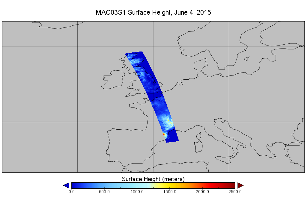
MODIS/Aqua Geolocation Fields 1km 5-Min 1A Wide Swath Subset along CloudSat V002 (MAC03S1) at GES DISC NGDA
This is the wide-swath MODIS/Aqua subset along CloudSat field of view track. The goal of the wide-swath subset is to select and return MODIS data that are within +-100 km across... -
MODIS/Terra Water Reservoir Monthly L3 Global V061 NGDA
The Terra Moderate Resolution Imaging Spectroradiometer (MODIS) Water Reservoir Monthly Level 3 (L3) Global (MOD28C3) Version 6.1 product provides current data for 151 man-made... -
ASTER Global Digital Elevation Model NetCDF V003 NGDA
The ASTER Global Digital Elevation Model (GDEM) Version 3 (ASTGTM) provides a global digital elevation model (DEM) of land areas on Earth at a spatial resolution of 1 arc second... -
ASTER Global Water Bodies Database V001 NGDA
The ASTER Global Water Bodies Database (ASTWBD) Version 1 data product provides global coverage of water bodies larger than 0.2 square kilometers at a spatial resolution of 1... -
ASTER Orthorectified Digital Elevation Model (DEM) V003 NGDA
The ASTER Digital Elevation Model and Orthorectified Registered Radiance at the Sensor (AST14DMO) product...

Official websites use .gov
A
.gov website belongs to an official government
organization in the United States.
Secure .gov websites use HTTPS
A
lock (
) or https:// means you’ve safely connected to
the .gov website. Share sensitive information only on official,
secure websites.