
-
Global Fire Emissions Database, Version 4.1 (GFEDv4) NGDA
This dataset provides global estimates of monthly burned area, monthly emissions and fractional contributions of different fire types, daily or 3-hourly fields to scale the... -
MODIS/Terra Net Evapotranspiration Gap-Filled 8-Day L4 Global 500m SIN Grid V061 NGDA
The MOD16A2GF Version 6.1 Evapotranspiration/Latent Heat Flux (ET/LE) product is a year-end gap-filled 8-day composite dataset produced at 500 meter (m) pixel resolution. The... -
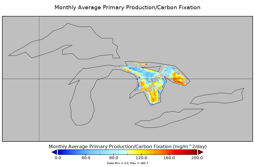
Carbon Monitoring System Lake Huron Primary Production Monthly V1 (CMSLakeHuronPPM) at GES DISC NGDA
Monthly Average primary production/carbon fixation data for Lake Huron. The primary production data is derived using MODIS imagery with model data. The NASA Carbon Monitoring... -
Fire Intensity and Burn Severity Metrics for Circumpolar Boreal Forests, 2001-2013 NGDA
This data set provides products characterizing immediate and longer-term ecosystem changes from fires in the circumpolar boreal forests of Northern Eurasia and North America.... -
Ecosystem Functional Type Distribution Map for the Conterminous USA, 2001-2014 NGDA
This dataset provides maps of the distribution of ecosystem functional types (EFTs) and the interannual variability of EFTs at 0.05 degree resolution across the conterminous... -
MODIS/Terra Net Primary Production Gap-Filled Yearly L4 Global 500m SIN Grid V061 NGDA
The MOD17A3HGF Version 6.1 product provides information about annual Gross and Net Primary Production (GPP and NPP) at 500 meter (m) pixel resolution. Annual Terra Moderate... -
MODIS/Aqua Net Primary Production Gap-Filled Yearly L4 Global 500m SIN Grid V061 NGDA
The MYD17A3HGF Version 6.1 product provides information about annual Gross and Net Primary Production (GPP and NPP) at 500 meter (m) pixel resolution. Annual Aqua Moderate... -
MODIS/Terra+Aqua Direct Broadcast Burned Area Monthly L3 Global 500m SIN Grid V061 NGDA
The Terra and Aqua combined MCD64A1 Version 6.1 Burned Area data product is a monthly, global gridded 500 meter (m) product containing per-pixel burned-area and quality... -
High Resolution Land Cover-Specific Solar-Induced Fluorescence, Midwestern USA, 2018 NGDA
This dataset provides estimated solar-induced chlorophyll fluorescence (SIF) of specific vegetation types and total SIF under clear-sky and real/cloudy conditions at a... -
ABoVE: Dall Sheep Lamb Recruitment and Climate Data, Alaska and NW Canada, 2000-2015 NGDA
This dataset contains estimated annual average Dall sheep (Ovis dalli dalli) lamb-to-ewe ratios for each year from 2000-2015 across the full species range in Alaska and... -
ABoVE: Burned Area, Depth, and Combustion for Alaska and Canada, 2001-2019 NGDA
This dataset provides annual gridded estimates of fire locations and associated burn fraction per pixel for Alaska and Canada at approximately 500 m spatial resolution for the... -
MODIS/Terra Thermal Anomalies/Fire 5-Min L2 Swath 1km V061 NGDA
The Moderate Resolution Imaging Spectroradiometer (MODIS) Thermal Anomalies and Fire MOD14 Version 6.1 product is produced daily in 5-minute temporal satellite increments... -
High Resolution Global Contiguous SIF Estimates from OCO-2 SIF and MODIS, Version 2 NGDA
This dataset provides spatially-contiguous global mean daily solar-induced chlorophyll fluorescence (SIF) estimates at 0.05 degree (approximately 5 km at the equator) spatial... -
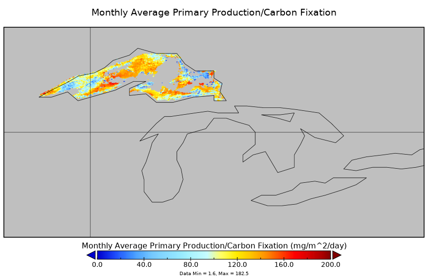
Carbon Monitoring System Lake Superior Primary Production Monthly V1 (CMSLakeSuperiorPPM) at GES DISC NGDA
Monthly Average primary production/carbon fixation data for Lake Superior. The primary production data is derived using MODIS imagery with model data. The NASA Carbon Monitoring... -
LBA-ECO LC-02 Hot Pixel Fire Indicator Data for Tri-national MAP Region: 2003-2006 NGDA
This data set provides hot pixel data, as an indicator of fires, that were detected by various satellites in the tri-national MAP region (Madre de Dios-Peru, Acre-Brazil, and... -
ABoVE: Ignitions, Burned Area, and Emissions of Fires in AK, YT, and NWT, 2001-2018 NGDA
This dataset provides estimates of daily burned area, carbon emissions, and uncertainty, and daily fire ignition locations for boreal fires in Alaska, U.S., and in the Yukon and... -
CARVE: Alaskan Fire Emissions Database (AKFED), 2001-2013 NGDA
This data set provides estimates of annual carbon emissions (kg carbon per square meter) from boreal fires at 450-m resolution for the state of Alaska between 2001 and 2013. To... -
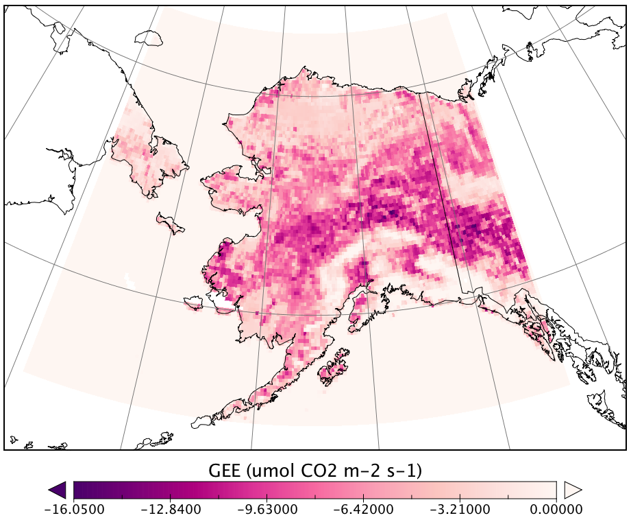
CARVE Modeled Gross Ecosystem CO2 Exchange and Respiration, Alaska, 2012-2014 NGDA
This data set provides 3-hourly estimates of gross ecosystem CO2 exchange (GEE) and respiration (autotrophic and heterotrophic) for the state of Alaska from 2012 to 2014. The... -
MODIS/Terra Thermal Anomalies/Fire 5-Min L2 Swath 1km NRT NGDA
The MODIS/Terra Thermal Anomalies/Fire 5-Min L2 Swath 1km Near Real Time (NRT), short name MOD14, product is primarily derived from MODIS 4- and 11-micrometer radiances. The...

Official websites use .gov
A
.gov website belongs to an official government
organization in the United States.
Secure .gov websites use HTTPS
A
lock (
) or https:// means you’ve safely connected to
the .gov website. Share sensitive information only on official,
secure websites.