
-
SWOT Level 2 Lake Single-Pass Vector Data Product, Version 2.0
The SWOT Level 2 Lake Single-Pass Vector Data Product from the Surface Water Ocean Topography (SWOT) mission provides water surface elevation, area, storage change derived from... -
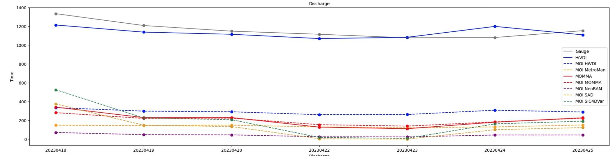
SWOT Sword of Science River Discharge Products Version 1
The SWOT Sword of Science River Discharge Products dataset from the Surface Water and Ocean Topography (SWOT) mission and produced by the Discharge Algorithm Working Group... -
Combined ASTER and MODIS Emissivity database over Land (CAMEL) Emissivity Monthly Global 0.05Deg V003 NGDA
The NASA Making Earth System Data Records for Use in Research Environments (MEaSUREs) (https://earthdata.nasa.gov/community/community-data-system-programs/measures-projects)... -
Pre SWOT Hydrology Global Lake/Reservoir Surface Inland Water Height GREALM V.2
The Global Lake/Reservoir Surface Inland Water Height Time Series is derived from the G-REALM10 lake level product https://ipad.fas.usda.gov/cropexplorer/global_reservoir/ The... -
Pre SWOT Hydrology GRRATS Virtual Station River Heights Version 2
The Global River Radar Altimeter Time Series (GRRATS) are simulated river gauge data that are derived from ERS-1, ERS-2, TOPEX/Poseidon OSTM/Jason-2, Jason-3 and Envisat... -
ABoVE: Environmental Conditions and Subsistence Resource Access, Alaska, 2016-2017
This dataset provides descriptions and photos of environmental conditions that impacted availability to subsistence resources by residents in nine rural communities within the... -
FIFE CDROM Vol. 3 Contents: NS001 Thematic Mapper Simulator (TMS) Imagery, 1987-1989
This data set provides aircraft-based NS001 Thematic Mapper Simulator (TMS) images of the study area associated with The First ISLSCP (International Satellite Land Surface... -
Pre SWOT Hydrology GRRATS Daily River Heights and Storage Version 2
The Global River Radar Altimeter Time Series (GRRATS) 1km/daily interpolations are river heights from ERS-1, ERS-2, TOPEX/Poseidon OSTM/Jason-2 and Envisat that are interpolated... -
Lake Bathymetry Maps derived from Landsat and Random Forest Modeling, North Slope, AK
This dataset provides lake bathymetry maps derived from Landsat surface reflectance products for a portion of the North Slope area of Alaska. A random forest regression... -
Global-Gridded Daily Methane Emissions from Inland Dam-Reservoir Systems
This dataset includes global maps of methane (CH4) emissions from inland dam-reservoir systems at 0.25-degree spatial resolution. Daily emission rates (as grams of CH4 per day... -
Delta-X: UAVSAR L3 Gridded Open Water Channels, MRD, Louisiana, USA, 2021
This dataset provides gridded estimates of water channels for the Atchafalaya and Terrebonne basins of the Mississippi River Delta in Louisiana, U.S.A. The data show channels... -
Pre-Delta-X: L3 AirSWOT-derived Water Level Profiles, Wax Lake Outlet, LA, USA, 2015
This dataset contains water level profiles generated from the AirSWOT data collected in the Atchafalaya Basin in Southern Louisiana, USA, within the Mississippi River Delta... -
ABoVE: Dall Sheep Lamb Recruitment and Climate Data, Alaska and NW Canada, 2000-2015 NGDA
This dataset contains estimated annual average Dall sheep (Ovis dalli dalli) lamb-to-ewe ratios for each year from 2000-2015 across the full species range in Alaska and... -
Water Security Indicator Model - Global Land Data Assimilation System (WSIM-GLDAS) Monthly Grids, Version 1
The Water Security Indicator Model - Global Land Data Assimilation System (WSIM-GLDAS) Monthly Grids, Version 1 data set identifies and characterizes surpluses and deficits of... -
Pre SWOT Hydrology Global Lake/Reservoir Surface Inland Water Area Extent V2 NGDA
The Global Lake/Reservoir Surface Inland Water Extent Mask Time Series are derived from the MODIS instruments. The purpose of this dataset is to provide surface water dynamics... -
SWOT Level 2 Water Mask Pixel Cloud Auxiliary Data Product, Version 2.0
Auxiliary information for pixel cloud product indicating to which water bodies the pixels are assigned in river and lake products. Also includes height-constrained pixel...

Official websites use .gov
A
.gov website belongs to an official government
organization in the United States.
Secure .gov websites use HTTPS
A
lock (
) or https:// means you’ve safely connected to
the .gov website. Share sensitive information only on official,
secure websites.