
-
Federal
Global Cyclone Mortality Risks and Distribution
National Aeronautics and Space Administration —
The Global Cyclone Mortality Risks and Distribution is a 2.5 minute grid of global cyclone mortality risks. Gridded Population of the World, Version 3 (GPWv3) data... -
Federal
NOAA Extended Reconstructed Sea Surface Temperature (ERSST), Version 5
National Oceanic and Atmospheric Administration, Department of Commerce —
The NOAA Extended Reconstructed Sea Surface Temperature (ERSST) dataset is a global monthly sea surface temperature dataset derived from the International... -
Federal
Extended Reconstructed Sea Surface Temperature (ERSST), Version 4
National Oceanic and Atmospheric Administration, Department of Commerce —
The Extended Reconstructed Sea Surface Temperature (ERSST) dataset is a global monthly sea surface temperature analysis on a 2x2 degree grid derived from the... -
Federal
SEAMAP Reef Fish Survey (1992 - 1997; and 2001 - 2015)
National Oceanic and Atmospheric Administration, Department of Commerce —
The Southeast Fisheries Science Center Mississippi Laboratories conducts standardized fisheries independent resource surveys in the Gulf of Mexico, South Atlantic,... -
Federal
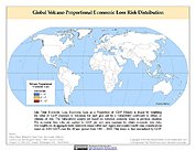
Global Volcano Proportional Economic Loss Risk Deciles
National Aeronautics and Space Administration —
Global Volcano Proportional Economic Loss Risk Deciles is a 2.5 minute grid of volcano hazard economic loss as proportions of Gross Domestic Product (GDP) per... -
Federal
NOAA/WDS Paleoclimatology - Wilson - Seminargasse 8-4 Straubing Historical Timbers - PCAB - ITRDB GERM139
National Oceanic and Atmospheric Administration, Department of Commerce —
This archived Paleoclimatology Study is available from the NOAA National Centers for Environmental Information (NCEI), under the World Data Service (WDS) for... -
Federal
NOAA/WDS Paleoclimatology - Wilson - Haselbrunweg 4 Bad Abbach Historical Timbers - ABAL - ITRDB GERM067
National Oceanic and Atmospheric Administration, Department of Commerce —
This archived Paleoclimatology Study is available from the NOAA National Centers for Environmental Information (NCEI), under the World Data Service (WDS) for... -
Federal
Stock Assessment Supplementary Information (SASINF)
National Oceanic and Atmospheric Administration, Department of Commerce —
In the interest of efficiency, clarity and standardization of stock assessment materials, the stock assessment reports for the 2015 Groundfish update have been... -
Federal
IVR Tilefish Database
National Oceanic and Atmospheric Administration, Department of Commerce —
This database contains weekly reports submitted by tilefish vessels with IVR reporting requirements. -
Federal
Global Multihazard Total Economic Loss Risk Deciles
National Aeronautics and Space Administration —
The Global Multihazard Total Economic Loss Risk Deciles is a 2.5 minute grid of global multihazard total economic loss risks. First, for each of the considered... -
Federal
IVR EFP Database
National Oceanic and Atmospheric Administration, Department of Commerce —
This database contains trip-level reports submitted by vessels participating in Exempted Fishery projects with IVR reporting requirements. -
Federal
Enhanced Biological Sampling Data
National Oceanic and Atmospheric Administration, Department of Commerce —
This is a database of a variety of biological, reproductive, and energetic data collected from fish on the continental shelf in the northwest Atlantic Ocean. Species... -
Federal
IVR RSA Database
National Oceanic and Atmospheric Administration, Department of Commerce —
This database contains trip-level reports submitted by vessels participating in Research Set-Aside projects with IVR reporting requirements. -
Federal
Global Landslide Mortality Risks and Distribution
National Aeronautics and Space Administration —
The Global Landslide Mortality Risks and Distribution is a 2.5 minute grid of global landslide mortality risks. Gridded Population of the World, Version 3 (GPWv3)... -
Federal
3D Visual Reconstruction for Rapid Archaeological Characterization
National Oceanic and Atmospheric Administration, Department of Commerce —
The use of optical mapping has the potential to create accurate and vastly higher-resolution models of submerged archaeological sites with a fraction of the time and... -
Federal
Groundswell Spatial Population and Migration Projections at One-Eighth Degree According to SSPs and RCPs, 2010-2050
National Aeronautics and Space Administration —
The Groundswell Spatial Population and Migration Projections at One-Eighth Degree According to SSPs and RCPs, 2010-2050, data set provides a baseline population... -
Federal
Atlantic Herring Acoustic Surveys
National Oceanic and Atmospheric Administration, Department of Commerce —
The NEFSC Advanced Sampling Technologies Research Group conducts annual fisheries acoustic surveys using state-of-the-art acoustic, midwater trawling, and underwater... -
Federal
Data on the Earth's Magnetic Field and its Secular Change since 1800
National Oceanic and Atmospheric Administration, Department of Commerce —
Information on the past and present orientation of the Earth's magnetic field is available from the National Geophysical Data Center (NGDC) which serves as the... -
Federal
NOAA/WDS Paleoclimatology - LOVECLIM Climate Model Simulation Constrained by Mann et al. 2009 Reconstruction
National Oceanic and Atmospheric Administration, Department of Commerce —
This archived Paleoclimatology Study is available from the NOAA National Centers for Environmental Information (NCEI), under the World Data Service (WDS) for...

Official websites use .gov
A
.gov website belongs to an official government
organization in the United States.
Secure .gov websites use HTTPS
A
lock (
) or https:// means you’ve safely connected to
the .gov website. Share sensitive information only on official,
secure websites.