
-
Federal
Global Earthquake Proportional Economic Loss Risk Deciles
National Aeronautics and Space Administration —
The Global Earthquake Proportional Economic Loss Risk Deciles is a 2.5 minute grid of earthquake hazard economic loss as proportions of Gross Domestic Product (GDP)... -
Federal
Global Cyclone Proportional Economic Loss Risk Deciles
National Aeronautics and Space Administration —
The Global Cyclone Proportional Economic Loss Risk Deciles is a 2.5 minute grid of cyclone hazard economic loss as proportions of Gross Domestic Product (GDP) per... -
Federal
NOAA Extended Reconstructed Sea Surface Temperature (ERSST), Version 5
National Oceanic and Atmospheric Administration, Department of Commerce —
The NOAA Extended Reconstructed Sea Surface Temperature (ERSST) dataset is a global monthly sea surface temperature dataset derived from the International... -
Federal
Global Volcano Total Economic Loss Risk Deciles
National Aeronautics and Space Administration —
Global Volcano Total Economic Loss Risk Deciles is a 2.5 minute grid of global volcano total economic loss risks. First, subnational distributions of Gross Domestic... -
Federal
Crustal Ages of the Ocean Floor - Poster
National Oceanic and Atmospheric Administration, Department of Commerce —
The Crustal Ages of the Ocean Floor Poster was created at NGDC using the Crustal Ages of the Ocean Floor database draped digitally over a relief of the ocean floor... -
Federal
NOAA/WDS Paleoclimatology - Bonney - Wanless Forest (Site 06) - ACSH - ITRDB CANA660
National Oceanic and Atmospheric Administration, Department of Commerce —
This archived Paleoclimatology Study is available from the NOAA National Centers for Environmental Information (NCEI), under the World Data Service (WDS) for... -
Federal
Global Multihazard Frequency and Distribution
National Aeronautics and Space Administration —
The Global Multihazard Frequency and Distribution is a 2.5 minute grid presenting a simple multihazard index based solely on summated single-hazard decile values. The... -
Federal
Extended Reconstructed Sea Surface Temperature (ERSST), Version 4
National Oceanic and Atmospheric Administration, Department of Commerce —
The Extended Reconstructed Sea Surface Temperature (ERSST) dataset is a global monthly sea surface temperature analysis on a 2x2 degree grid derived from the... -
Federal
Uncertainty table for lidar-derived shorelines used when calculating rates in the Digital Shoreline Analysis System software for southern North Carolina (NCsouth)
Department of the Interior —
Sandy ocean beaches are a popular recreational destination, often surrounded by communities containing valuable real estate. Development is on the rise despite the... -
Federal
Global Drought Proportional Economic Loss Risk Deciles
National Aeronautics and Space Administration —
The Global Drought Proportional Economic Loss Risk Deciles is a 2.5 minute grid of drought hazard economic loss as proportions of Gross Domestic Product (GDP) per... -
Federal
Fishing Revenue-Intensity Raster Database, 2007-2012
National Oceanic and Atmospheric Administration, Department of Commerce —
These revenue-intensity rasters were built as part of an effort to improve upon the spatial precision of self-reported Vessel Trip Report (VTR) fishing locations.... -
Federal
Gas chemistry and isotope compositions at Sulphur Banks, Kīlauea Volcano, Hawai`i
Department of the Interior —
Sulphur Banks, near the summit of Kīlauea Volcano on the Island of Hawai`i, is a thermal area where volcanic gases and steam are discharged. A research well drilled... -
Federal
IVR Herring Database
National Oceanic and Atmospheric Administration, Department of Commerce —
This database contains weekly reports submitted by herring vessels with IVR reporting requirements. -
Federal
Data on the Earth's Magnetic Field and its Secular Change since 1800
National Oceanic and Atmospheric Administration, Department of Commerce —
Information on the past and present orientation of the Earth's magnetic field is available from the National Geophysical Data Center (NGDC) which serves as the... -
Federal
NOAA/WDS Paleoclimatology - LOVECLIM Climate Model Simulation Constrained by Mann et al. 2009 Reconstruction
National Oceanic and Atmospheric Administration, Department of Commerce —
This archived Paleoclimatology Study is available from the NOAA National Centers for Environmental Information (NCEI), under the World Data Service (WDS) for... -
Federal
NOAA/WDS Paleoclimatology - Hessl fire data from Bogd Mountain - IMPD MNBOG001
National Oceanic and Atmospheric Administration, Department of Commerce —
This archived Paleoclimatology Study is available from the NOAA National Centers for Environmental Information (NCEI), under the World Data Service (WDS) for... -
Federal
EK60 Water Column Sonar Data Collected During NF-12-05-SBNMS
National Oceanic and Atmospheric Administration, Department of Commerce —
Cruise NF-12-05-SBNMS (Stellwagen Bank National Marine Sanctuary) (EK60). The project will place synchronous motion, acoustic recording tags on humpback and fin... -
Federal
Stock Assessment Supplementary Information (SASINF)
National Oceanic and Atmospheric Administration, Department of Commerce —
In the interest of efficiency, clarity and standardization of stock assessment materials, the stock assessment reports for the 2015 Groundfish update have been... -
Federal
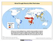
Global Drought Mortality Risks and Distribution
National Aeronautics and Space Administration —
The Global Drought Mortality Risks and Distribution is a 2.5 minute grid of global drought mortality risks. Gridded Population of the World, Version 3 (GPWv3) data...

Official websites use .gov
A
.gov website belongs to an official government
organization in the United States.
Secure .gov websites use HTTPS
A
lock (
) or https:// means you’ve safely connected to
the .gov website. Share sensitive information only on official,
secure websites.