

18 datasets found for "Hazardous Substances"
-
Federal
EPA Facility Registry Service (FRS): Facility Interests Dataset Download
U.S. Environmental Protection Agency —
This downloadable data package consists of location and facility identification information from EPA's Facility Registry Service (FRS) for all sites that are... -
Federal
Cleanups In My Community (CIMC) - Brownfields Properties, National Layer
U.S. Environmental Protection Agency —
This data layer provides access to Brownfields Properties as part of the CIMC web service, although the data are generally more broadly applicable. Brownfields are... -
Federal
EPA Facility Registry Service (FRS): SEMS_NPL
U.S. Environmental Protection Agency —
This web feature service contains location and facility identification information from EPA's Facility Registry Service (FRS) for the subset of facilities that are... -
City
NESHAP Notifications Tied To Demolition Activity, January 2009 to April 2015
City of Ferndale, Michigan —
NESHAP is a program of the United States Environmental Protection Agency that regulates hazardous air pollutants and ensures that construction and demolition... -
Federal
Trace Atmospheric Gas Analyzer (TAGA) Volatile Organic Compound (VOC) Data for BP Spill/Deepwater Horizon - August 2010
U.S. Environmental Protection Agency —
The Trace Atmospheric Gas Analyzer (TAGA) buses are self-contained mobile laboratories that conduct instant-result monitoring of air quality at particular locations.... -
City
Brownfields
City of Ferndale, Michigan —
The analyst downloaded the raw data used to develop this dataset from the Michigan Department of Environmental Quality (MDEQ). Pursuant to statutory guidelines under... -
Federal
FF Site Information
U.S. Environmental Protection Agency —
This asset includes the EPA Federal Agency Hazardous Waste Compliance Docket (Docket), which is required by Section 120(c) of the Comprehensive Environmental... -
Federal
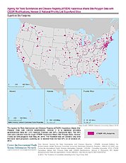
ATSDR Hazardous Waste Site Polygon Data with CIESIN Modifications, Version 2
National Aeronautics and Space Administration —
The Agency for Toxic Substances and Disease Registry (ATSDR) Hazardous Waste Site Polygon Data with CIESIN Modifications, Version 2 is a database providing... -
Federal
Trace Atmospheric Gas Analyzer (TAGA) Volatile Organic Compound (VOC) Data for BP Spill/Deepwater Horizon - July 2010
U.S. Environmental Protection Agency —
The Trace Atmospheric Gas Analyzer (TAGA) buses are self-contained mobile laboratories that conduct instant-result monitoring of air quality at particular locations.... -
Federal
Cleanups In My Community (CIMC) - Superfund National Priority List (NPL) Sites, National Layer
U.S. Environmental Protection Agency —
This data layer provides access to Superfund National Priority List Sites as part of the CIMC web service. Superfund is a program administered by the EPA to locate,... -
Federal
Trace Atmospheric Gas Analyzer (TAGA) Volatile Organic Compound (VOC) Data for BP Spill/Deepwater Horizon - May 2010
U.S. Environmental Protection Agency —
The Trace Atmospheric Gas Analyzer (TAGA) buses are self-contained mobile laboratories that conduct instant-result monitoring of air quality at particular locations.... -
Federal
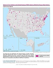
ATSDR Hazardous Waste Site Polygon Data, Version 2
National Aeronautics and Space Administration —
The Agency for Toxic Substances and Disease Registry (ATSDR) Hazardous Waste Site Polygon Data, Version 2 consists of 2,080 polygons for selected hazardous waste... -
State
Hazardous Materials Storage Sites
State of Oregon —
This dataset contains lat/long mapping coordinates to verify addresses for the Oregon State Fire Marshal (OSFM) – Community Right to Know (CR2K), CHS Manager... -
Federal
Cleanups In My Community (CIMC) - Removals/Responses, National Layer
U.S. Environmental Protection Agency —
This data layer provides access to Removal/Response sites as part of the CIMC web service. Removals are hazardous substance releases that require immediate or short-... -
Federal
MITRE WaterSHEDs PFAS vulnerability model output for Upper Colorado River Basin at 1 km, 9 km, and 100 km hexagonal tessellations
Department of the Interior —
Per- and polyfluoroalkyl substances (PFAS) in the aquatic environment present a water resource management challenge, in part due to the geospatial distribution of... -
Federal
Trace Atmospheric Gas Analyzer (TAGA) Volatile Organic Compound (VOC) Data for BP Spill/Deepwater Horizon - June 2010
U.S. Environmental Protection Agency —
The Trace Atmospheric Gas Analyzer (TAGA) buses are self-contained mobile laboratories that conduct instant-result monitoring of air quality at particular locations.... -
Federal
Water quality and contaminants in stream surface waters collected in the Delmarva Peninsula, 2022
Department of the Interior —
This data release contains the concentration and quality assurance results for 29 streams, sampled twice, and 1 stream, sampled once, in the Chesapeake Bay Delmarva... -
Federal
Trace Atmospheric Gas Analyzer (TAGA) Volatile Organic Compound (VOC) Data for BP Spill/Deepwater Horizon - August 2010
U.S. Environmental Protection Agency —
The Trace Atmospheric Gas Analyzer (TAGA) buses are self-contained mobile laboratories that conduct instant-result monitoring of air quality at particular locations....
18 datasets found for "Hazardous Substances"