

35 datasets found for ""Electric Power""
-
Federal
Compilation of Geospatial Data (GIS) for the Mineral Industries and Related Infrastructure of Africa
Department of the Interior —
This geodatabase reflects the U.S. Geological Survey’s (USGS) ongoing commitment to its mission of understanding the nature and distribution of global mineral... -
Federal
Compilation of Geospatial Data (GIS) for the Mineral Industries and Related Infrastructure of the People's Republic of China
Department of the Interior —
The U.S. Geological Survey (USGS) has compiled a geodatabase containing mineral-related geospatial data for the People's Republic of China. The data can be used in... -
Emissions Inventory
District of Columbia —
NEI point sources include emissions estimates for larger sources that are located at a fixed, stationary location. Point sources in the NEI include large industrial... -
City
Bike Plus Network
City of Seattle —
The Bicycle and E-Mobility Element of the STP will help create a safer, more bikeable Seattle. It provides a foundation for the City of Seattle to grow our investment... -
City
Bicycle Catalyst Projects
City of Seattle —
The Bicycle and E-Mobility Element of the STP will help create a safer, more bikeable Seattle. It provides a foundation for the City of Seattle to grow our investment... -
Federal
National Emissions Inventory (NEI), County-Level, US, 2008, 2011, 2014, EPA OAR, OAPQS
U.S. Environmental Protection Agency —
This US EPA Office of Air and Radiation, Office of Air Quality Planning and Standards, Air Quality Assessment Division, Air Quality Analysis Group (OAR, OAQPS, AQAD,... -
Federal
National Emissions Inventory (NEI), Facility-Level, US, 2008, 2011, 2014, EPA OAR, OAPQS
U.S. Environmental Protection Agency —
This US EPA Office of Air and Radiation, Office of Air Quality Planning and Standards, Air Quality Assessment Division, Air Quality Analysis Group (OAR, OAQPS, AQAD,... -
Federal
Last of the Wild Project, Version 3 (LWP-3): 2009 Human Footprint, 2018 Release
National Aeronautics and Space Administration —
The 2009 Human Footprint, 2018 Release provides a global map of the cumulative human pressure on the environment in 2009, at a spatial resolution of ~1 km. The human... -
Federal
Compilation of Geospatial Data (GIS) for the Mineral Industries and Related Infrastructure of Select Countries in Southwest Asia
Department of the Interior —
The U.S. Geological Survey (USGS) has compiled a geodatabase containing mineral-related geospatial data for 10 countries of interest in Southwest Asia (area of... -
Federal
Voice and data telecommunications restoration curves for 17 counties affected by the April 18, 2018, M7.0 HayWired earthquake scenario mainshock
Department of the Interior —
These data are a series of telecommunications voice and data restoration percentages for 17 counties affected by the HayWired earthquake scenario, a magnitude 7.0... -
Federal
Woods Hole Oceanographic Institute's Martha's Vineyard Coastal Observatory component locations (ESRI POINT SHAPEFILE, MVCO)
Department of the Interior —
The Woods Hole Oceanographic Institution has built the Martha's Vineyard Coastal Observatory (MVCO) near South Beach in Edgartown, Massachusetts. The project was... -
Federal
Deep ocean CTD data 2011-2013 from the Aloha Cabled Observatory (NCEI Accession 0123115)
National Oceanic and Atmospheric Administration, Department of Commerce —
The ALOHA Cabled Observatory (ACO) is a system of hardware and software that extends electric power and the Internet offshore, supporting sustained real-time... -
Federal
Identified Moderate and High Temperature Geothermal Systems
Department of the Interior —
This layer contains the locations of identified moderate (90 - 150° C) and high (> 150° C) temperature geothermal systems and associated reservoir volumes,... -
Federal
Results of collocated lifeline exposure to hazards resulting from the April 18, 2018, HayWired earthquake scenario for counties and cities in the San Francisco Bay area, California
Department of the Interior —
These data are a compilation of potential collocations between various lifeline infrastructure systems (transportation, water supply and wastewater, oil and gas,... -
City
Seattle Transportation Plan Bicycle Element
City of Seattle —
The Bicycle and E-Mobility Element of the STP will help create a safer, more bikeable Seattle. It provides a foundation for the City of Seattle to grow our investment... -
Federal
National Emissions Inventory, U.S., 2014, EPA/OAR/OAQPS/AQAD
U.S. Environmental Protection Agency —
This web service contains layers that depict annual emissions for 2014 at the facility and county level for the following criterial pollutants: CO, Lead, NH3, NOx,... -
Federal
Spatial and bathymetric data for Lago Patillas, Puerto Rico, August 2019
Department of the Interior —
Metadata for this geodatabase describe datasets included in the bathymetric study completed for Lago Patillas in August 2019. The U.S. Geological Survey, in... -
Federal
Deep ocean current profiles, water temperatures, and echo amplitudes from bottom-moored ADCP during 2011-2013 of the Aloha Cabled Observatory (NCEI Accession 0123608)
National Oceanic and Atmospheric Administration, Department of Commerce —
The ALOHA Cabled Observatory (ACO) is a system of hardware and software that extends electric power and the Internet offshore, supporting sustained real-time... -
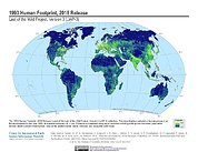
Federal
Last of the Wild Project, Version 3 (LWP-3): 1993 Human Footprint, 2018 Release
National Aeronautics and Space Administration —
The 1993 Human Footprint, 2018 Release provides a global map of the cumulative human pressure on the environment in 1993, at a spatial resolution of ~1 km. The human...
35 datasets found for ""Electric Power""