
-
Federal
NOAA Raster Navigational Charts (RNC) NGDA
National Oceanic and Atmospheric Administration, Department of Commerce —
NOAA, National Ocean Service, Office of Coast Survey, Marine Chart Division is responsible to build and maintain a suite of more than 1000 nautical charts that are... -
Federal
MarineCadastre.gov
National Oceanic and Atmospheric Administration, Department of Commerce —
MarineCadastre.gov is a marine information system that provides authoritative ocean data, offshore planning tools, and technical support to the offshore renewable... -
Federal
Aids to Navigation (ATONS) GIS data from the Gulf of America and coastal waters of Alabama, Florida, Louisiana, Mississippi and Texas as of 1999-10-21 (NCEI Accession 0000599)
National Oceanic and Atmospheric Administration, Department of Commerce —
This dataset contains a GIS database of Aids to Navigation in the Gulf of America and coastal waters of Alabama, Florida, Louisiana, Mississippi and Texas. These data... -
Federal
Office of Coast Survey's Collection of Print on Demand Charts (POD)
National Oceanic and Atmospheric Administration, Department of Commerce —
NOAA, National Ocean Service, Office of Coast Survey is responsible to build and maintain a suite of more than 1000 nautical charts that are used by commercial and... -
Federal
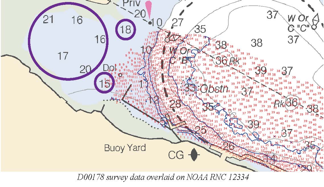
D00178: NOS Hydrographic Survey , 2013-04-29
National Oceanic and Atmospheric Administration, Department of Commerce —
The National Oceanic and Atmospheric Administration (NOAA) has the statutory mandate to collect hydrographic data in support of nautical chart compilation for safe... -
Federal
Lighthouses - Hawaii
National Oceanic and Atmospheric Administration, Department of Commerce —
Locations of lighthouses and minor coastal lights for the State of Hawaii. These aids to navigation (ATONs) are used to mark dangerous coastlines, hazardous shoals... -
Federal
Aids To Navigation (ATON) Buoys - Hawaii
National Oceanic and Atmospheric Administration, Department of Commerce —
Displays the location of buoys for the State of Hawaii as recorded on NOAA nautical charts, which are used as aids to navigation (ATONs) to indicate traffic channels,... -
Federal
Aids To Navigation (ATON) Beacons - Hawaii
National Oceanic and Atmospheric Administration, Department of Commerce —
Displays the location of marine beacons for the State of Hawaii as recorded on NOAA nautical charts. While buoys float at the surface of the water, beacons are fixed... -
Federal
Beacons - Saipan, CNMI
National Oceanic and Atmospheric Administration, Department of Commerce —
Beacon locations around Saipan, Commonwealth of the Northern Mariana Islands (CNMI). -
Federal
Landmarks For Navigation - Saipan and Tinian, CNMI
National Oceanic and Atmospheric Administration, Department of Commerce —
Landmarks to aid in navigation around Saipan and Tinian, Commonwealth of the Northern Mariana Islands (CNMI). -
Federal
Aids To Navigation (ATON) Lights - Hawaii
National Oceanic and Atmospheric Administration, Department of Commerce —
Displays the locations of lights for the State of Hawaii as recorded on NOAA nautical charts. These aids to navigation (ATONs) are used in conjunction with beacons... -
Federal
Buoys - Saipan and Tinian, CNMI
National Oceanic and Atmospheric Administration, Department of Commerce —
Buoys around Saipan and Tinian, Commonwealth of the Northern Mariana Islands (CNMI).

Official websites use .gov
A
.gov website belongs to an official government
organization in the United States.
Secure .gov websites use HTTPS
A
lock (
) or https:// means you’ve safely connected to
the .gov website. Share sensitive information only on official,
secure websites.