
-
Federal
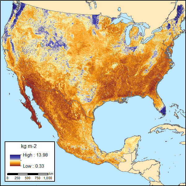
Soil Organic Carbon Estimates for 30-cm Depth, Mexico and Conterminous USA, 1991-2011
National Aeronautics and Space Administration —
This dataset provides two sets of gridded estimates of estimated soil organic carbon (SOC) and associated uncertainties for 0-30 cm topsoil layer in kg SOC/m2 at... -
City
Louisville KY Litter Bins
Louisville Metro Government —
This dataset contains a current record of garbage bins by type across Metro Louisville USD. Records contained were intitally digitized using SWMS records and aerial... -
Federal
TIGER/Line Shapefile, 2022, State, Florida, FL, 2020 Census Block
U.S. Census Bureau, Department of Commerce —
The TIGER/Line shapefiles and related database files (.dbf) are an extract of selected geographic and cartographic information from the U.S. Census Bureau's Master... -
Federal
Predicted H5 and H7 subtype Avian Influenza Prevalence for Wild Waterfowl Species Across the Continental United States
Department of the Interior —
This data release provides the predicted proportion of influenza-positive birds testing positive for H5 and H7 subtypes of IAV for each species at monthly intervals... -
Federal
Multi-Mission Optimally Interpolated Sea Surface Salinity Global Monthly Dataset V1
National Aeronautics and Space Administration —
This is a level 4 product on a 0.25-degree spatial and monthly temporal grid. The product is the monthly mean of the level 4 OISSS dataset using three satellite... -
Federal
Laser ablation inductively coupled plasma mass spectrometry (LA-ICP-MS) geochemical data for apatite grains in rocks and stream sediments from the Taurus porphyry copper deposit area, eastern Tanacross quadrangle, Alaska
Department of the Interior —
Laser ablation inductively coupled plasma mass spectrometry (LA-ICP-MS) analyses of apatite provide trace element concentrations that support indicator mineral... -
City
ThirdGrade ELA Math Scores byCities 08032017
City of Ferndale, Michigan —
Third grade English Language Arts (ELA) and Math test results for the school year 2016-2017 by city for the state of Michigan. Data Driven Detroit obtained these... -
Federal
Keamuku Maneuver Area random plot vegetation, geology, coordinates 2013
Department of the Interior —
This data release includes data and metadata on 155 vegetation plots that were random stratified across different substrate ages and geological features at Keamuku... -
Federal
Digital Geologic Sample Localities Map for the Painted Hills Unit, John Day Fossil Beds National Monument, Oregon, Plate III (NPS, GRD, GRE, JODA)
Department of the Interior —
The Digital Geologic Sample Localities Map for the Painted Hills Unit, John Day Fossil Beds National Monument, Oregon (Plate III) is composed of GIS data layers... -
Federal
TIGER/Line Shapefile, Current, County, Wayne County, NC, All Roads
U.S. Census Bureau, Department of Commerce —
This resource is a member of a series. The TIGER/Line shapefiles and related database files (.dbf) are an extract of selected geographic and cartographic information... -
Federal
TIGER/Line Shapefile, Current, County, Davis County, IA, All Roads
U.S. Census Bureau, Department of Commerce —
This resource is a member of a series. The TIGER/Line shapefiles and related database files (.dbf) are an extract of selected geographic and cartographic information... -
Federal
Potential Explanatory Factors for Groundwater Quality in the Northern Sierra Nevada Foothills Domestic-Aquifer Assessment Study Units, 2015-2017: California GAMA Priority Basin Project
Department of the Interior —
This data release codifies and attributes explanatory factors that could potentially impact groundwater quality at 142 groundwater sites (wells or developed springs)... -
Federal
Nearshore bathymetry of the Columbia River littoral cell, Washington and Oregon, 2021
Department of the Interior —
This portion of the USGS data release presents bathymetry data collected during surveys performed in the Columbia River littoral cell, Washington and Oregon, in 2021... -
Federal
H11608: NOS Hydrographic Survey , Approaches to Cordova, Alaska, 2006-10-27
National Oceanic and Atmospheric Administration, Department of Commerce —
The National Oceanic and Atmospheric Administration (NOAA) has the statutory mandate to collect hydrographic data in support of nautical chart compilation for safe... -
Federal
NOAA Shallow-Water Benthic Habitats: CNMI: Guguan
National Oceanic and Atmospheric Administration, Department of Commerce —
Benthic habitat maps for the nearshore, shallow (< 30 m) coastal waters of the island of Guguan in the Commonwealth of the Northern Mariana Islands (CNMI). NOAA's... -
Federal
TIGER/Line Shapefile, 2022, County, Warren County, NJ, Address Range-Feature
U.S. Census Bureau, Department of Commerce —
The TIGER/Line shapefiles and related database files (.dbf) are an extract of selected geographic and cartographic information from the U.S. Census Bureau's Master... -
Federal
2022 Cartographic Boundary File (KML), Current State and Equivalent for United States, 1:5,000,000
U.S. Census Bureau, Department of Commerce —
The 2022 cartographic boundary KMLs are simplified representations of selected geographic areas from the U.S. Census Bureau's Master Address File / Topologically... -
Federal
Microplastics in the Alplaus Kill at Glenridge, NY (01355470), 2018-2019
Department of the Interior —
This dataset enumerates the type, size, and color of microplastic particles collected every two weeks from the Alplaus Kill at Glenridge Road in Schenectady, NY... -
Federal
TIGER/Line Shapefile, 2021, County, Talbot County, GA, All Roads
U.S. Census Bureau, Department of Commerce —
The TIGER/Line shapefiles and related database files (.dbf) are an extract of selected geographic and cartographic information from the U.S. Census Bureau's Master...

Official websites use .gov
A
.gov website belongs to an official government
organization in the United States.
Secure .gov websites use HTTPS
A
lock (
) or https:// means you’ve safely connected to
the .gov website. Share sensitive information only on official,
secure websites.