Methane Emissions from Dairy Sources (Vista-CA), State of California, USA, 2019
Access & Use Information
Downloads & Resources
-
Google Scholar search resultsHTML
Search results for publications that cite this dataset by its DOI.
-
Download this datasetHTML
This link allows direct data access via Earthdata login
-
View documentation related to this datasetHTML
ORNL DAAC Data Set Documentation
-
This dataset's landing pageHTML
Data set Landing Page DOI URL
-
View documentation related to this datasetPDF
Methane Emissions from Dairy Sources (Vista-CA), State of California, USA,...
-
Get a related visualizationJPEG
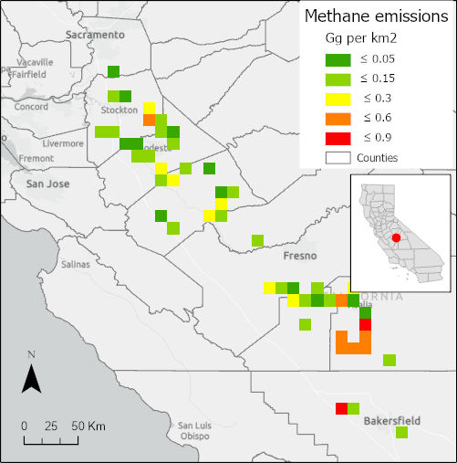
Total methane emissions from dairy farms in the central valley of California,...
-
Landing PageLanding Page
Dates
| Metadata Created Date | May 30, 2023 |
|---|---|
| Metadata Updated Date | December 6, 2023 |
Metadata Source
- Data.json Data.json Metadata
Harvested from NASA Data.json
Graphic Preview

Additional Metadata
| Resource Type | Dataset |
|---|---|
| Metadata Created Date | May 30, 2023 |
| Metadata Updated Date | December 6, 2023 |
| Publisher | ORNL_DAAC |
| Maintainer | |
| Identifier | C2515935936-ORNL_CLOUD |
| Data First Published | 2021-06-28 |
| Language | en-US |
| Data Last Modified | 2023-06-12 |
| Category | NACP, geospatial |
| Public Access Level | public |
| Bureau Code | 026:00 |
| Metadata Context | https://project-open-data.cio.gov/v1.1/schema/catalog.jsonld |
| Metadata Catalog ID | https://data.nasa.gov/data.json |
| Schema Version | https://project-open-data.cio.gov/v1.1/schema |
| Catalog Describedby | https://project-open-data.cio.gov/v1.1/schema/catalog.json |
| Citation | Marklein, A.R., D. Meyer, M.L. Fischer, S. Jeong, T. Rafiq, M. Carr, and F.M. Hopkins. 2021. Methane Emissions from Dairy Sources (Vista-CA), State of California, USA, 2019. ORNL DAAC, Oak Ridge, Tennessee, USA. https://doi.org/10.3334/ORNLDAAC/1902 |
| Graphic Preview Description | Total methane emissions from dairy farms in the central valley of California, USA, in 2019. Inset below legend shows the location of this area within the state. Source: total_CH4_Gg_km2.tif |
| Graphic Preview File | https://daac.ornl.gov/NACP/guides/Dairy_Methane_CA_V1-2_Fig1.jpg |
| Harvest Object Id | 53b41b25-3b4b-4c71-a4f3-cc48b035ea26 |
| Harvest Source Id | 58f92550-7a01-4f00-b1b2-8dc953bd598f |
| Harvest Source Title | NASA Data.json |
| Homepage URL | https://doi.org/10.3334/ORNLDAAC/1902 |
| Metadata Type | geospatial |
| Old Spatial | -124.29 32.73 -115.29 41.93 |
| Program Code | 026:001 |
| Source Datajson Identifier | True |
| Source Hash | a727575cdd63d79add07b67f883c65f8cdc019a81a279b57b2d510f44ca1f8ea |
| Source Schema Version | 1.1 |
| Spatial | |
| Temporal | 2019-01-01T00:00:00Z/2019-12-31T23:59:59Z |
Didn't find what you're looking for? Suggest a dataset here.

