

MERRA-2 tavgM_2d_csp_Nx: 2d,Monthly mean,Time-averaged,Single-Level,Assimilation,COSP Satellite Simulator 0.625 x 0.5 degree V5.12.4 (M2TMNXCSP) at GES DISC
Access & Use Information
Downloads & Resources
-
Google Scholar search resultsHTML
Search results for publications that cite this dataset by its DOI.
-
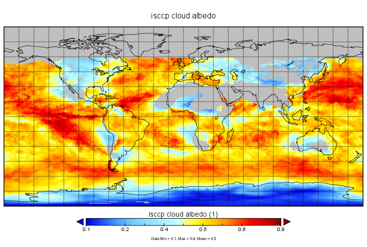
Get a related visualizationPNG
M2TMNXCSP variable
-
View this dataset's how-to documentationHTML
How to read and plot the data.
-
This dataset's landing pageHTML
Access the dataset landing page from the GES DISC website.
-
Download this dataset through a directory mapHTML
Access the data via HTTPS.
-
Get a related visualization through GIOVANNIHTML
The GES-DISC Interactive Online Visualization ANd aNalysis Interface...
-
Download this dataset through Earthdata SearchHTML
Use the Earthdata Search to find and retrieve data sets across multiple data...
-
Use GRADS DATA SERVER (GDS) to access the...HTML
The GrADS Data Server (GDS) is another form of OPeNDAP that provides...
-
Use OPeNDAP to access the dataset's dataHTML
Access the data via the OPeNDAP protocol.
-
Use THREDDS DATA to download the dataset's dataHTML
Time aggregated THREDDS Data Server (TDS)
-
The dataset's project home pageHTML
The GMAO MERRA-2 documentation and FAQs
-
View the primary investigator's documentation...PDF
MERRA-2 File Specification Document
-
View this dataset's read me documentPDF
README Document
-
View documentation related to this datasetHTML
MERRA-2 Data Access – Quick Start Guide
-
View an important notice for this datasetHTML
Records of MERRA-2 Data Reprocessing and Service Changes
-
View documentation related to this datasetHTML
FAQs about MERRA-2 data access
-
Landing PageLanding Page
References
Dates
| Metadata Created Date | March 13, 2024 |
|---|---|
| Metadata Updated Date | March 13, 2024 |
Metadata Source
- Data.json Data.json Metadata
Harvested from NASA Data.json
Graphic Preview
Additional Metadata
| Resource Type | Dataset |
|---|---|
| Metadata Created Date | March 13, 2024 |
| Metadata Updated Date | March 13, 2024 |
| Publisher | NASA/GSFC/SED/ESD/GCDC/GESDISC |
| Maintainer | |
| Identifier | C1276812867-GES_DISC |
| Data First Published | 2007-06-14 |
| Language | en-US |
| Data Last Modified | 2015-07-07 |
| Category | MERRA-2, geospatial |
| Public Access Level | public |
| Bureau Code | 026:00 |
| Metadata Context | https://project-open-data.cio.gov/v1.1/schema/catalog.jsonld |
| Metadata Catalog ID | https://data.nasa.gov/data.json |
| Schema Version | https://project-open-data.cio.gov/v1.1/schema |
| Catalog Describedby | https://project-open-data.cio.gov/v1.1/schema/catalog.json |
| Citation | Global Modeling and Assimilation Office (GMAO). 2015-06-30. M2TMNXCSP. Version 5.12.4. MERRA-2 tavgM_2d_csp_Nx: 2d,Monthly mean,Time-averaged,Single-Level,Assimilation,COSP Satellite Simulator V5.12.4. Greenbelt, MD, USA. Archived by National Aeronautics and Space Administration, U.S. Government, Goddard Earth Sciences Data and Information Services Center (GES DISC). https://doi.org/10.5067/BZPOTGJOQKLU. https://disc.gsfc.nasa.gov/datacollection/M2TMNXCSP_5.12.4.html. Digital Science Data. |
| Creator | Global Modeling and Assimilation Office (GMAO) |
| Data Presentation Form | Digital Science Data |
| Graphic Preview Description | The GES-DISC Interactive Online Visualization ANd aNalysis Interface (Giovanni) is a web-based tool that allows users to interactively visualize and analyze data. |
| Graphic Preview File | https://giovanni.gsfc.nasa.gov/giovanni/#dataKeyword=M2TMNXCSP |
| Harvest Object Id | 588776a4-fd47-4464-a5d5-41034b2e3b07 |
| Harvest Source Id | 58f92550-7a01-4f00-b1b2-8dc953bd598f |
| Harvest Source Title | NASA Data.json |
| Homepage URL | https://doi.org/10.5067/BZPOTGJOQKLU |
| Metadata Type | geospatial |
| Old Spatial | -180.0 -90.0 180.0 90.0 |
| Program Code | 026:001 |
| Related Documents | https://doi.org/10.1175/JCLI-D-16-0758.1, https://doi.org/10.5194/gmd-8-1339-2015, https://doi.org/10.1175/JCLI-D-16-0609.1, https://doi.org/10.1175/JCLI-D-16-0613.1, https://doi.org/10.1175/JCLI-D-16-0570.1, https://doi.org/10.1175/JCLI-D-16-0720.1, https://doi.org/NASA/TM%E2%80%932015-104606/Vol.%2043, https://doi.org/10.1177/1094342005056120 |
| Release Place | Greenbelt, MD, USA |
| Series Name | M2TMNXCSP |
| Source Datajson Identifier | True |
| Source Hash | e9790d3537c61b0b1120c8195447985d57a534e09443d814a242276cd8cfdf8d |
| Source Schema Version | 1.1 |
| Spatial | |
| Temporal | 1980-01-01T00:00:00Z/2022-01-17T00:00:00Z |
Didn't find what you're looking for? Suggest a dataset here.