ASCENDS: Active Sensing of CO2 With AVOCET, California and Nevada, 2016
Access & Use Information
Downloads & Resources
-
Google Scholar search resultsHTML
Search results for publications that cite this dataset by its DOI.
-
Download this datasetHTML
This link allows direct data access via Earthdata login
-
View documentation related to this datasetHTML
ORNL DAAC Data Set Documentation
-
This dataset's landing pageHTML
Data set Landing Page DOI URL
-
View documentation related to this datasetPDF
ASCENDS: Active Sensing of CO2 With AVOCET, California and Nevada, 2016:...
-
View documentation related to this datasetPDF
ASCENDS: Active Sensing of CO2 With AVOCET, California and Nevada, 2016:...
-
View documentation related to this datasetPDF
ASCENDS: Active Sensing of CO2 With AVOCET, California and Nevada, 2016:...
-
View documentation related to this datasetPDF
ASCENDS: Active Sensing of CO2 With AVOCET, California and Nevada, 2016:...
-
Get a related visualizationPNG
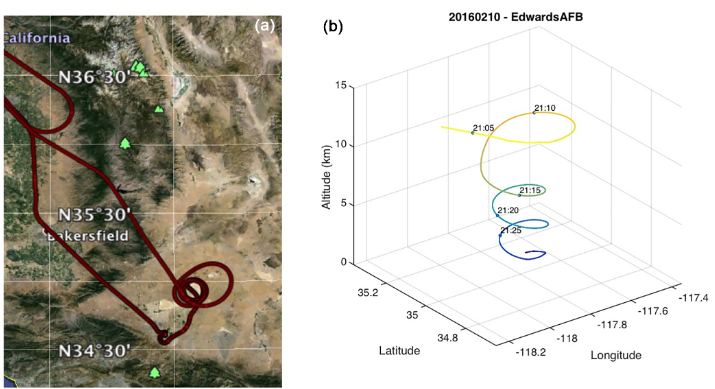
(a) Flight track for 10 February 2016 flight over Edwards AFB, California....
-
Landing PageLanding Page
Dates
| Metadata Created Date | July 27, 2023 |
|---|---|
| Metadata Updated Date | December 6, 2023 |
Metadata Source
- Data.json Data.json Metadata
Harvested from NASA Data.json
Graphic Preview

Additional Metadata
| Resource Type | Dataset |
|---|---|
| Metadata Created Date | July 27, 2023 |
| Metadata Updated Date | December 6, 2023 |
| Publisher | ORNL_DAAC |
| Maintainer | |
| Identifier | C2734409850-ORNL_CLOUD |
| Data First Published | 2022-12-29 |
| Language | en-US |
| Data Last Modified | 2023-07-18 |
| Category | ASCENDS Airborne, geospatial |
| Public Access Level | public |
| Bureau Code | 026:00 |
| Metadata Context | https://project-open-data.cio.gov/v1.1/schema/catalog.jsonld |
| Metadata Catalog ID | https://data.nasa.gov/data.json |
| Schema Version | https://project-open-data.cio.gov/v1.1/schema |
| Catalog Describedby | https://project-open-data.cio.gov/v1.1/schema/catalog.json |
| Citation | Abshire, J.B., J. Mao, H. Riris, S.R. Kawa, and X. Sun. 2022. ASCENDS: Active Sensing of CO2 With AVOCET, California and Nevada, 2016. ORNL DAAC, Oak Ridge, Tennessee, USA. https://doi.org/10.3334/ORNLDAAC/2115 |
| Graphic Preview Description | (a) Flight track for 10 February 2016 flight over Edwards AFB, California. (b) Time-tagged location and altitude plot for the spiral-down maneuver over Edwards AFB for the same flight (Abshire et al., 2018). |
| Graphic Preview File | https://daac.ornl.gov/ASCENDS/guides/ASCENDS_AVOCET_CA_NV_Feb_2016_Fig1.png |
| Harvest Object Id | ed734d53-d071-4ae4-b650-4b14026ffc4c |
| Harvest Source Id | 58f92550-7a01-4f00-b1b2-8dc953bd598f |
| Harvest Source Title | NASA Data.json |
| Homepage URL | https://doi.org/10.3334/ORNLDAAC/2115 |
| Metadata Type | geospatial |
| Old Spatial | -122.1 34.55 -113.53 41.61 |
| Program Code | 026:001 |
| Source Datajson Identifier | True |
| Source Hash | 0ee4d40236770b92f66a5100386900dd1c42ac5fea5dfa883a24460d397dc712 |
| Source Schema Version | 1.1 |
| Spatial | |
| Temporal | 2016-02-10T14:35:28Z/2016-02-12T02:46:50Z |
Didn't find what you're looking for? Suggest a dataset here.

