ACT-America: CPL-derived Atmospheric Boundary Layer Top Height, Eastern US, 2016-2018
Access & Use Information
Downloads & Resources
-
Google Scholar search resultsHTML
Search results for publications that cite this dataset by its DOI.
-
Download this datasetHTML
This link allows direct data access via Earthdata login
-
View documentation related to this datasetHTML
ORNL DAAC Data Set Documentation
-
This dataset's landing pageHTML
Data set Landing Page DOI URL
-
View documentation related to this datasetPDF
ACT-America: CPL-derived Atmospheric Boundary Layer Top Height, Eastern US,...
-
View documentation related to this datasetPDF
ACT-America: CPL-derived Atmospheric Boundary Layer Top Height, Eastern US,...
-
View documentation related to this datasetPDF
ACT-America: CPL-derived Atmospheric Boundary Layer Top Height, Eastern US,...
-
View documentation related to this datasetPDF
ACT-America: CPL-derived Atmospheric Boundary Layer Top Height, Eastern US,...
-
View documentation related to this datasetPDF
ACT-America: CPL-derived Atmospheric Boundary Layer Top Height, Eastern US,...
-
Get a related visualizationPNG
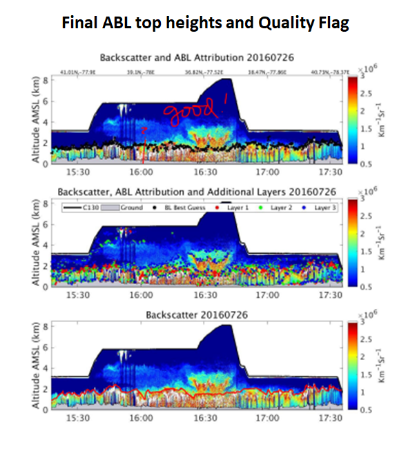
Top panel: As annotated during expert review, showing time-height cross-...
-
The dataset's project home pageHTML
ACT-America Campaign Site
-
Landing PageLanding Page
Dates
| Metadata Created Date | May 30, 2023 |
|---|---|
| Metadata Updated Date | December 7, 2023 |
Metadata Source
- Data.json Data.json Metadata
Harvested from NASA Data.json
Graphic Preview

Additional Metadata
| Resource Type | Dataset |
|---|---|
| Metadata Created Date | May 30, 2023 |
| Metadata Updated Date | December 7, 2023 |
| Publisher | ORNL_DAAC |
| Maintainer | |
| Identifier | C2677226029-ORNL_CLOUD |
| Data First Published | 2021-11-23 |
| Language | en-US |
| Data Last Modified | 2023-06-12 |
| Category | ACT-America, geospatial |
| Public Access Level | public |
| Bureau Code | 026:00 |
| Metadata Context | https://project-open-data.cio.gov/v1.1/schema/catalog.jsonld |
| Metadata Catalog ID | https://data.nasa.gov/data.json |
| Schema Version | https://project-open-data.cio.gov/v1.1/schema |
| Catalog Describedby | https://project-open-data.cio.gov/v1.1/schema/catalog.json |
| Citation | Pal, S., K.J. Davis, R.M. Pauly, M.J. McGill, L.J. Campbell, K. Hoffman, A.M. Alejandro, M. Rench, and H. Haas. 2021. ACT-America: CPL-derived Atmospheric Boundary Layer Top Height, Eastern US, 2016-2018. ORNL DAAC, Oak Ridge, Tennessee, USA. https://doi.org/10.3334/ORNLDAAC/1825 |
| Graphic Preview Description | Top panel: As annotated during expert review, showing time-height cross-section of aerosol backscatter profiles measured using CPL onboard C-130 aircraft on 2016-07-26 during a frontal crossing research flight over the Mid-Atlantic region along with the wavelet-derived ABL top (black solid-circles) height overlaid. Blue to red color bar scale represents low to high normalized aerosol backscatter signal (in a.u.). Middle: Secondary aerosol layers overlaid on the top panel. Bottom: Final attributed ABL top heights. Temporal resolution of the ABL top heights and other aerosol layers is 8 seconds. |
| Graphic Preview File | https://daac.ornl.gov/ACTAMERICA/guides/CPL_ABL_Top_Height_Fig1.png |
| Harvest Object Id | 60355106-a208-47df-bee1-47fe475aa163 |
| Harvest Source Id | 58f92550-7a01-4f00-b1b2-8dc953bd598f |
| Harvest Source Title | NASA Data.json |
| Homepage URL | https://doi.org/10.3334/ORNLDAAC/1825 |
| Metadata Type | geospatial |
| Old Spatial | -106.49 27.25 -64.0 50.0 |
| Program Code | 026:001 |
| Source Datajson Identifier | True |
| Source Hash | 5169430e1ddd9566670ee053090fc03495dcf61dd1bcda5546ba39d21b5c632f |
| Source Schema Version | 1.1 |
| Spatial | |
| Temporal | 2016-07-18T00:00:00Z/2018-05-20T23:59:00Z |
Didn't find what you're looking for? Suggest a dataset here.

