A Compilation of Global Soil Microbial Biomass Carbon, Nitrogen, and Phosphorus Data
Access & Use Information
Downloads & Resources
-
Google Scholar search resultsHTML
Search results for publications that cite this dataset by its DOI.
-
Download this datasetHTML
This link allows direct data access via Earthdata login
-
View documentation related to this datasetHTML
ORNL DAAC Data Set Documentation
-
This dataset's landing pageHTML
Data set Landing Page DOI URL
-
View documentation related to this datasetPDF
Data Set Documentation
-
View documentation related to this datasetCSV
Data Set Documentation
-
View documentation related to this datasetPDF
Data Set Documentation
-
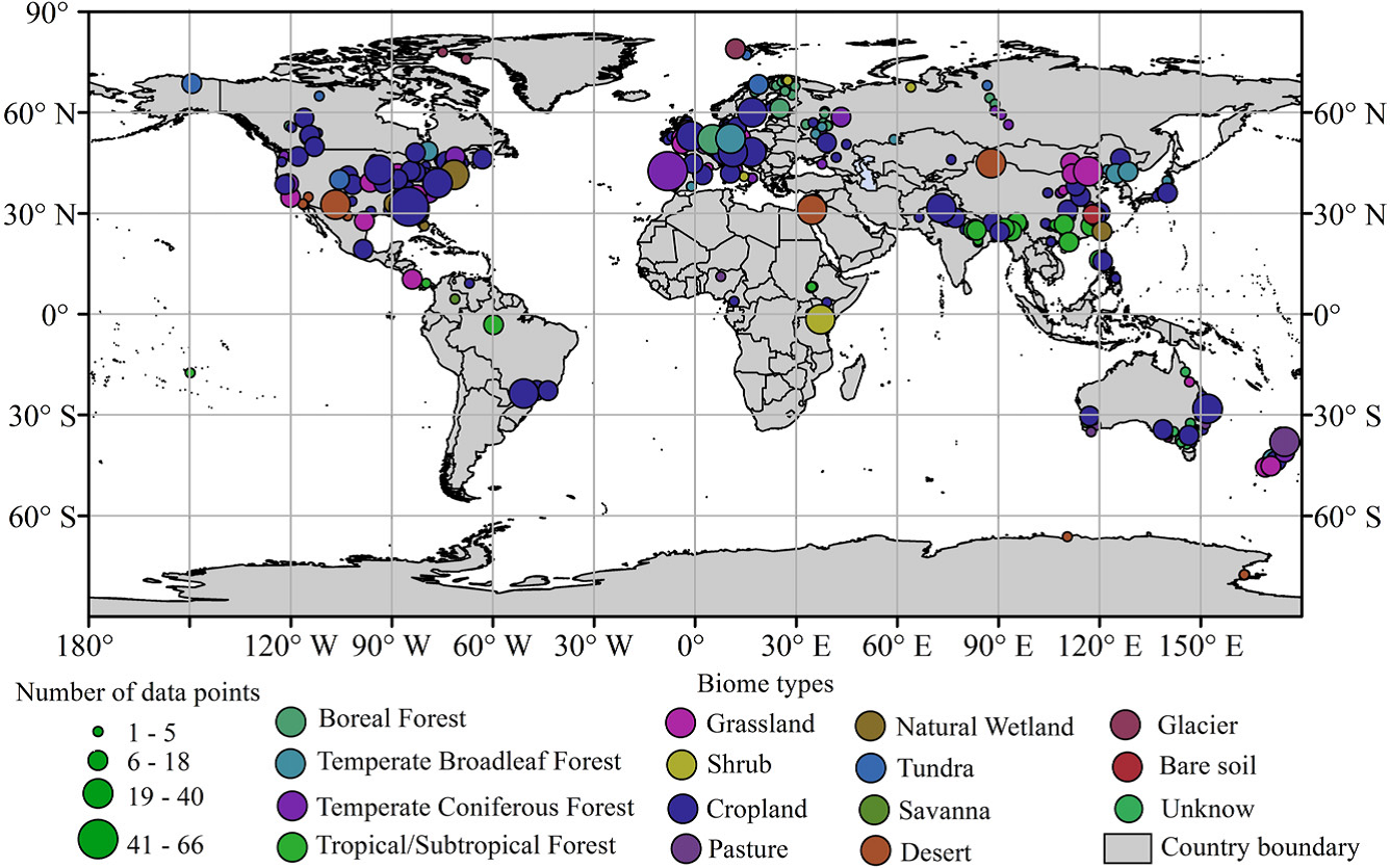
Get a related visualizationPNG
Distribution of the data points used in this study.
-
Landing PageLanding Page
Dates
| Metadata Created Date | December 1, 2022 |
|---|---|
| Metadata Updated Date | December 6, 2023 |
Metadata Source
- Data.json Data.json Metadata
Harvested from NASA Data.json
Graphic Preview

Additional Metadata
| Resource Type | Dataset |
|---|---|
| Metadata Created Date | December 1, 2022 |
| Metadata Updated Date | December 6, 2023 |
| Publisher | ORNL_DAAC |
| Maintainer | |
| Identifier | C2216863966-ORNL_CLOUD |
| Data First Published | 2015-01-12 |
| Language | en-US |
| Data Last Modified | 2023-06-12 |
| Category | Soil, geospatial |
| Public Access Level | public |
| Bureau Code | 026:00 |
| Metadata Context | https://project-open-data.cio.gov/v1.1/schema/catalog.jsonld |
| Metadata Catalog ID | https://data.nasa.gov/data.json |
| Schema Version | https://project-open-data.cio.gov/v1.1/schema |
| Catalog Describedby | https://project-open-data.cio.gov/v1.1/schema/catalog.json |
| Citation | Xu, X., P.E. Thornton, and P. Potapov. 2014. A Compilation of Global Soil Microbial Biomass Carbon, Nitrogen, and Phosphorus Data. ORNL DAAC, Oak Ridge, Tennessee, USA. http://dx.doi.org/10.3334/ORNLDAAC/1264 |
| Graphic Preview Description | Distribution of the data points used in this study. |
| Graphic Preview File | https://daac.ornl.gov/SOILS/guides/fig_1_global_biomass.png |
| Harvest Object Id | 3050ee16-462b-4700-8606-71cd18be9c67 |
| Harvest Source Id | 58f92550-7a01-4f00-b1b2-8dc953bd598f |
| Harvest Source Title | NASA Data.json |
| Homepage URL | https://doi.org/10.3334/ORNLDAAC/1264 |
| Metadata Type | geospatial |
| Old Spatial | -180.0 -90.0 177.9 79.0 |
| Program Code | 026:001 |
| Source Datajson Identifier | True |
| Source Hash | 81f8f8cdf8077321f0b41bb10848a44e5f8c7cd3661fbfc2c6aa70843c6bab9c |
| Source Schema Version | 1.1 |
| Spatial | |
| Temporal | 1977-11-16T00:00:00Z/2012-06-01T23:59:59Z |
Didn't find what you're looking for? Suggest a dataset here.

