

984 datasets found for "edi"
-
Federal
Enterprise Data Inventory (EDI) Progress Information
Social Security Administration —
Social Security continues to release data in support of the open data initiative. See www.ssa.gov/data for a summary of our efforts and our enterprise data listing.... -
Federal
HHS Enterprise Data Inventory: 2016-08 HHS EDI JSON
U.S. Department of Health & Human Services —
The Enterprise Data Inventory (EDI) is the comprehensive inventory listing of agency data resources including public, restricted public, and non-public datasets. -
Federal
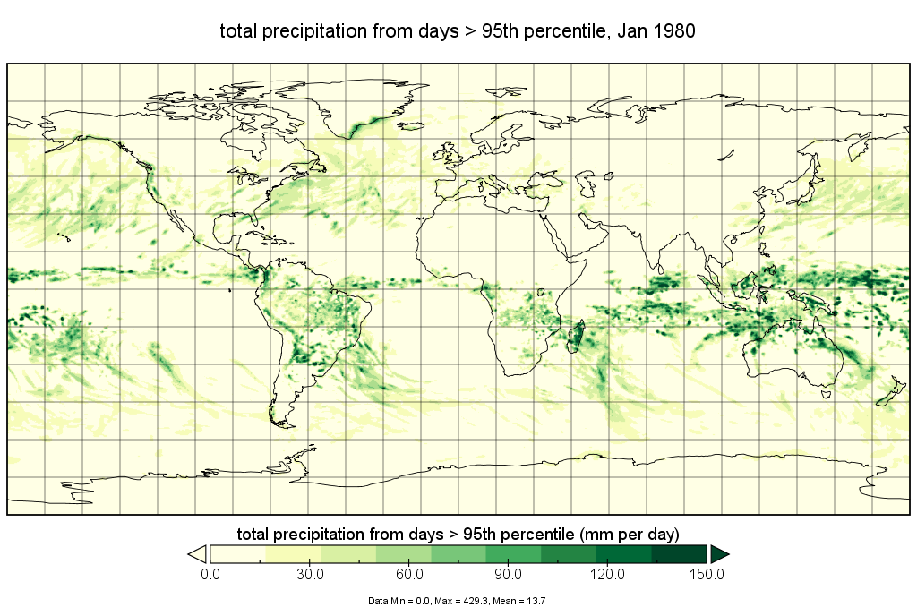
MERRA-2 statM_2d_edi_Nx: 2d, Single-Level, Monthly Extremes Detection Indices V1 (M2SMNXEDI) at GES DISC
National Aeronautics and Space Administration —
The Modern Era Retrospective analysis for Research and Applications, Version 2 (MERRA-2) contains a wealth of information that can be used for weather and climate... -
Federal
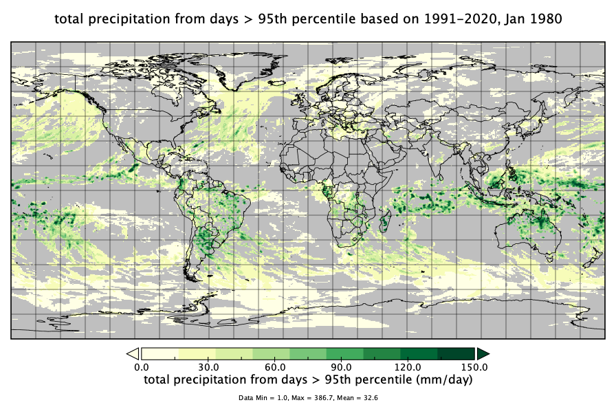
MERRA-2 statM_2d_edi_Nx: 2d, Single-Level, Monthly Extremes Detection Indices based on 1991-2020 V2 (M2SMNXEDI) at GES DISC
National Aeronautics and Space Administration —
M2SMNXEDI (or statM_2d_edi_Nx) is a 2-dimensional monthly data collection for extreme detection indices derived from daily Modern-Era Retrospective analysis for... -
Federal
GSS Contractor Performance
General Services Administration —
This dashboard provides insight into the shipping, tracking, delivery, transition to EDI/Contractor Portal etc. from Fax contractors etc. -
Federal
Low-Resolution North Pacific Nearshore Buffer shapefile
Department of the Interior —
This shapefile approximates the area less than 20 km offshore of the North Pacific Coastline as defined by the "World Country Boundaries (Generalized)" shapefile... -
Federal
Low-Resolution North Pacific Nearshore Buffer shapefile
Department of the Interior —
This shapefile approximates the area less than 20 km offshore of the North Pacific Coastline as defined by the "World Country Boundaries (Generalized)" shapefile... -
Federal
BIA BOGS OneMap- Applications
Department of the Interior —
StoryMaps, Web Applications, and Web Maps allow users to explore data at a deeper level. -
Federal
BLM CO Resource Use Stipulations
Department of the Interior —
Resource stipulations for fluid mineral leasing including No Surface Occupancy, Controlled Surface Use and Timing Limitations -
Federal
BLM AK Oil and Gas Lease Tract - NPRA
Department of the Interior —
The authorized oil and gas leases dataset is produced on a regular basis by the Bureau of Land Management, Alaska State Office. -
Federal
BLM AK Oil and Gas Leases
Department of the Interior —
The authorized oil and gas leases dataset is produced on a regular basis by the Bureau of Land Management, Alaska State Office. -
Federal
BLM AK Protracted Grids
Department of the Interior —
Township and section boundaries were generated from geodetic latitude and longitude coordinate pairs as recorded on BLM's official protraction diagrams of the state... -
Federal
BLM AK Protracted Section
Department of the Interior —
Township and section boundaries were generated from geodetic latitude and longitude coordinate pairs as recorded on BLM's official protraction diagrams of the state... -
Federal
BLM AK Protracted Township
Department of the Interior —
Township and section boundaries were generated from geodetic latitude and longitude coordinate pairs as recorded on BLM's official protraction diagrams of the state... -
Federal
BLM CA WHB Herd Area Polygon
Department of the Interior —
Polygon features depicting the Wild Horse and Burro Herd Areas. -
Federal
BLM CA WHB Herd Management Area Documents Table
Department of the Interior —
Polygon features depicting the Wild Horse and Burro Herd Areas. -
Federal
BLM CA WHB Herd Management Area Polygon
Department of the Interior —
Polygon features depicting the Wild Horse and Burro Herd Areas. -
Federal
BLM CA Wild Horse and Burro Herd Areas Polygon
Department of the Interior —
Polygon features depicting the Wild Horse and Burro Herd Areas. -
Federal
BLM CO GUSG EIS RMPA Locatable Mineral Alternatives
Department of the Interior —
This polygon feature class represents the spatial extent and boundaries for Gunnison Sage-Grouse EIS RMP Amendment project data. -
Federal
BLM CO GUSG EIS RMPA Recreation Alternatives
Department of the Interior —
This polygon feature class represents the spatial extent and boundaries for Gunnison Sage-Grouse EIS RMP Amendment project data.
984 datasets found for "edi"