
-
Federal
NCDC Storm Events Database 188 recent views
National Oceanic and Atmospheric Administration, Department of Commerce —
Storm Data is provided by the National Weather Service (NWS) and contain statistics on personal injuries and damage estimates. Storm Data covers the United States of... -
Federal
Integrated Surface Dataset (Global) 166 recent views
National Oceanic and Atmospheric Administration, Department of Commerce —
The Integrated Surface Dataset (ISD) is composed of worldwide surface weather observations from over 35,000 stations, though the best spatial coverage is evident in... -
Federal
U.S. Billion-dollar Weather and Climate Disasters, 1980 - present (NCEI Accession 0209268) 56 recent views
National Oceanic and Atmospheric Administration, Department of Commerce —
This NCEI accession contains U.S. disaster cost assessments of the total, direct losses ($) inflicted by: tropical cyclones, inland floods, drought & heat waves,... -
Federal
NOAA Weather and Climate Toolkit (WCT)
National Oceanic and Atmospheric Administration, Department of Commerce —
The NOAA Weather and Climate Toolkit is an application that provides simple visualization and data export of weather and climatological data archived at NCDC. The... -
Federal
NOAA/WDS Paleoclimatology - Saladyga fire data from Tuul River - IMPD MNTUL001
National Oceanic and Atmospheric Administration, Department of Commerce —
This archived Paleoclimatology Study is available from the NOAA National Centers for Environmental Information (NCEI), under the World Data Service (WDS) for... -
State
California's Groundwater Update 2020 (Bulletin 118)
State of California —
California's Groundwater Update 2020 (CalGW) is California's foremost technical publication on groundwater in the state of California. CalGW, formally known as... -
State
California Groundwater Elevation Monitoring (CASGEM) Program
State of California —
Since 2009, the California Statewide Groundwater Elevation Monitoring (CASGEM) Program has tracked seasonal and long-term groundwater elevation trends in groundwater... -
Federal
NOAA/WDS Paleoclimatology - Bigio fire data from Okino Klyuchi, Siberia - IMPD RUOKI001
National Oceanic and Atmospheric Administration, Department of Commerce —
This archived Paleoclimatology Study is available from the NOAA National Centers for Environmental Information (NCEI), under the World Data Service (WDS) for... -
Federal
NOAA/WDS Paleoclimatology - Bigio fire data from Kyachta/Selenga boundary, Siberia - IMPD RUKYB001
National Oceanic and Atmospheric Administration, Department of Commerce —
This archived Paleoclimatology Study is available from the NOAA National Centers for Environmental Information (NCEI), under the World Data Service (WDS) for... -
Federal
ECOSTRESS Evapotranspiration dis-ALEXI USDA Daily L3 Global 30m V001
National Aeronautics and Space Administration —
The ECOsystem Spaceborne Thermal Radiometer Experiment on Space Station (ECOSTRESS) mission measures the temperature of plants to better understand how much water... -
Federal
Crop Year 2014 Drought Specific Disaster Designations Map
Department of Agriculture —
Crop year 2014 US map at the county level shows drought-specific disaster designations across the country under USDA's amended rule. -
Federal
ABoVE: Synthesis of Burned and Unburned Forest Site Data, AK and Canada, 1983-2016
National Aeronautics and Space Administration —
This dataset is a synthesis of field plot characterization data, derived above-ground and below-ground combusted carbon, and acquired Fire Weather Index (FWI) System... -
Federal
WLDAS Noah-MP 3.6 Land Surface Model L4 Daily 0.01 degree x 0.01 degree Version D1.0 (WLDAS_NOAHMP001_DA1) at GES DISC
National Aeronautics and Space Administration —
The Western Land Data Assimilation System (WLDAS), developed at Goddard Space Flight Center (GSFC) and funded by the NASA Western Water Applications Office, provides... -
Federal
Crop Year 2013 Drought Specific Disaster Designations Map
Department of Agriculture —
Crop year 2013 US map at the county level shows drought-specific disaster designations across the country under USDA's amended rule. -
Federal
ECOSTRESS Evaporative Stress Index dis-ALEXI Daily L4 CONUS 70 m V001
National Aeronautics and Space Administration —
The ECOsystem Spaceborne Thermal Radiometer Experiment on Space Station (ECOSTRESS) mission measures the temperature of plants to better understand how much water... -
Federal
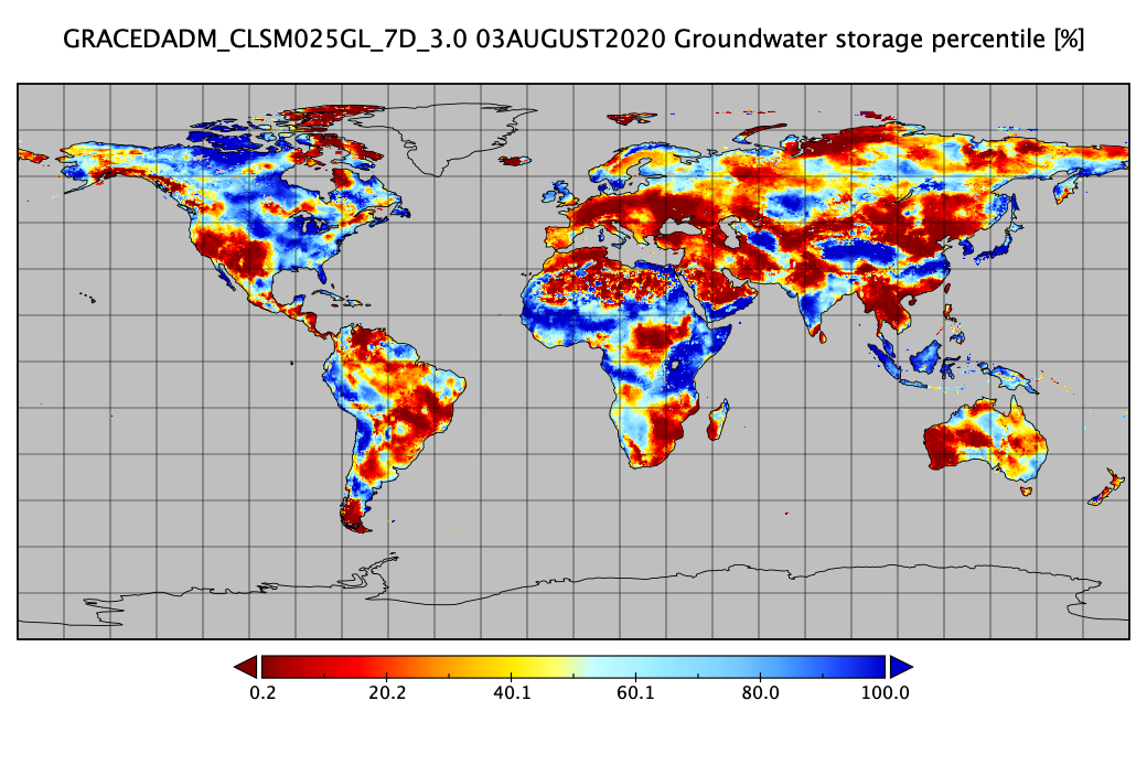
Groundwater and Soil Moisture Conditions from GRACE and GRACE-FO Data Assimilation L4 7-days 0.25 x 0.25 degree Global V3.0 (GRACEDADM_CLSM025GL_7D) at GES DISC
National Aeronautics and Space Administration —
Scientists at NASA Goddard Space Flight Center generate groundwater and soil moisture drought indicators each week. They are based on terrestrial water storage... -
State
Water Shortage Vulnerability Technical Methods
State of California —
These documents present the 2023 updates to the Water Shortage Vulnerability scoring for both (and separately) rural communities as domestic wells and state small... -
Federal
NOAA/WDS Paleoclimatology - Bigio fire data from Vallecito Country Market, San Juan Mountains - IMPD USVCM001
National Oceanic and Atmospheric Administration, Department of Commerce —
This archived Paleoclimatology Study is available from the NOAA National Centers for Environmental Information (NCEI), under the World Data Service (WDS) for... -
Federal
NOAA/WDS Paleoclimatology - Bigio fire data from Klyuchi village, Siberia - IMPD RUKLU001
National Oceanic and Atmospheric Administration, Department of Commerce —
This archived Paleoclimatology Study is available from the NOAA National Centers for Environmental Information (NCEI), under the World Data Service (WDS) for... -
Federal
NOAA/WDS Paleoclimatology - Bigio fire data from Marina Basin (Vallecito Reservoir), San Juan Mountains - IMPD USMAR001
National Oceanic and Atmospheric Administration, Department of Commerce —
This archived Paleoclimatology Study is available from the NOAA National Centers for Environmental Information (NCEI), under the World Data Service (WDS) for...

Official websites use .gov
A
.gov website belongs to an official government
organization in the United States.
Secure .gov websites use HTTPS
A
lock (
) or https:// means you’ve safely connected to
the .gov website. Share sensitive information only on official,
secure websites.