
-
Federal
H02770A: NOS Hydrographic Survey
National Oceanic and Atmospheric Administration, Department of Commerce —
The National Oceanic and Atmospheric Administration (NOAA) has the statutory mandate to collect hydrographic data in support of nautical chart compilation for safe... -
Federal
H10165: NOS Hydrographic Survey , Southern California Coast, California, 1985-05-01
National Oceanic and Atmospheric Administration, Department of Commerce —
The National Oceanic and Atmospheric Administration (NOAA) has the statutory mandate to collect hydrographic data in support of nautical chart compilation for safe... -
Federal
H02769: NOS Hydrographic Survey
National Oceanic and Atmospheric Administration, Department of Commerce —
The National Oceanic and Atmospheric Administration (NOAA) has the statutory mandate to collect hydrographic data in support of nautical chart compilation for safe... -
Federal
H02770: NOS Hydrographic Survey
National Oceanic and Atmospheric Administration, Department of Commerce —
The National Oceanic and Atmospheric Administration (NOAA) has the statutory mandate to collect hydrographic data in support of nautical chart compilation for safe... -
Federal
Technical Report-Rare Earth Element Concentrations in Wyoming's Produced Waters
Department of Energy —
This study is a joint effort by the University of Wyoming (UW), the UW Engineering Department (UW-ENG), and Idaho National Laboratories (INL) and the United States... -
Federal
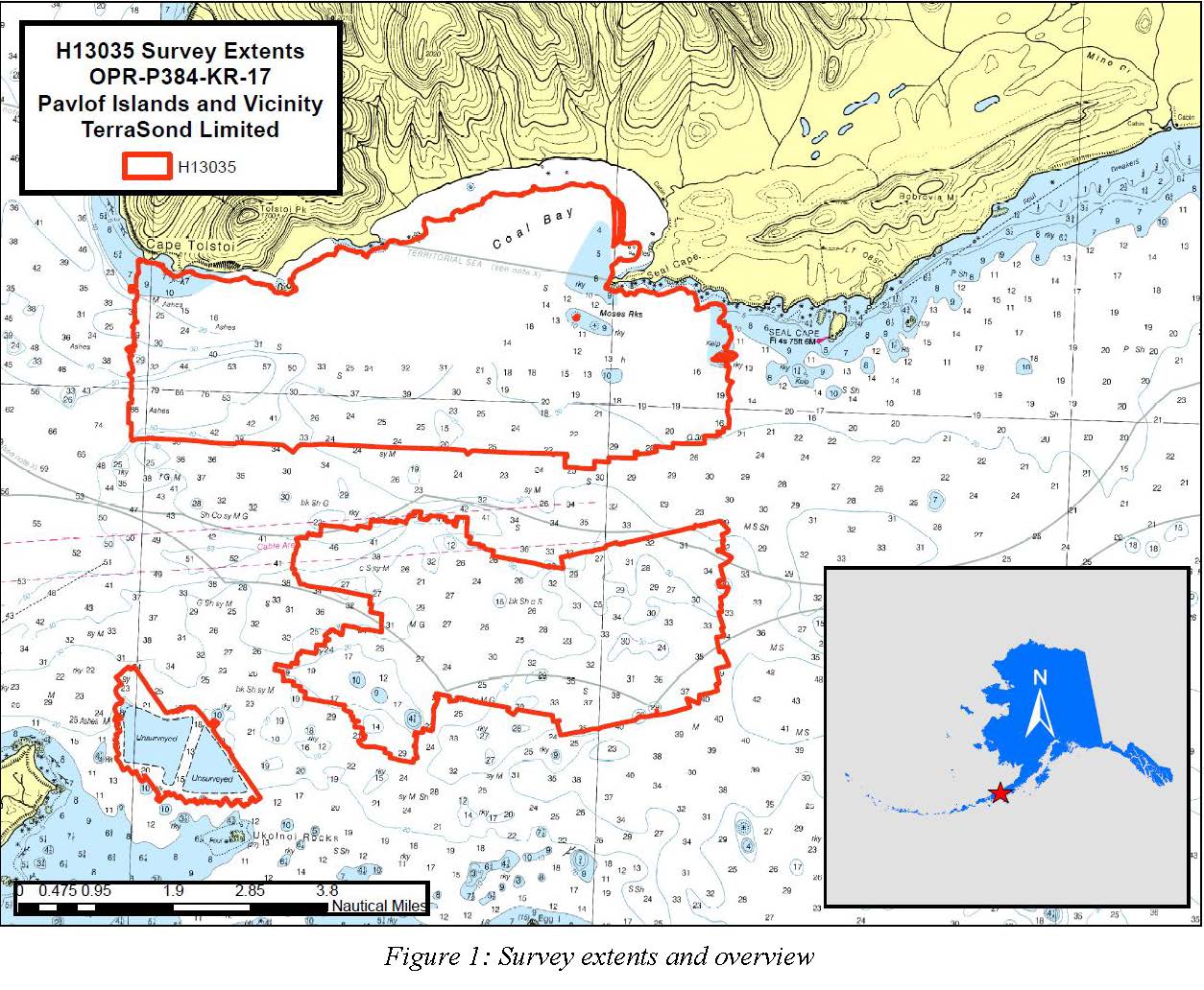
H13035: NOS Hydrographic Survey , Pavlof Islands and Vicinity, 2017-09-26
National Oceanic and Atmospheric Administration, Department of Commerce —
The National Oceanic and Atmospheric Administration (NOAA) has the statutory mandate to collect hydrographic data in support of nautical chart compilation for safe... -
Federal
Digital Geologic-GIS Map of Johnstown Flood National Memorial and portions of Allegheny Portage Railroad National Historic Site, Pennsylvania (NPS, GRD, GRI, JOFL, JOFL_ALPO digital map) adapted from a Pennsylvania Geological Survey Water Resource Report map by McElroy (1998)
Department of the Interior —
The Digital Geologic-GIS Map of Johnstown Flood National Memorial and portions of Allegheny Portage Railroad National Historic Site, Pennsylvania is composed of GIS... -
Federal
Locations and numbers of past producing metal and coal mining projects
U.S. Environmental Protection Agency —
Locations and numbers of past producing metal and coal mining projects in NW US and Canada. This dataset is associated with the following publication: Sergeant, C.,... -
Federal
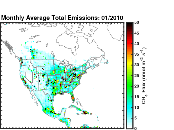
Methane (CH4) Flux for North America L4 Daily V1 (CMS_CH4_FLX_NAD) at GES DISC
National Aeronautics and Space Administration —
The CMS Methane (CH4) Flux for North America data set contains estimates of methane emission in North America based on an inversion of the GEOS-Chem chemical... -
Federal
Global Inventory of Methane Emissions from Fuel Exploitation V1 (GFEI_CH4)
National Aeronautics and Space Administration —
This is a global inventory of methane emissions from fuel exploitation (GFEI) created for the NASA Carbon Monitoring System (CMS). The emission sources represented in... -
Federal
Soot, organics, and ultrafine ash from air- and oxy-fired coal combustion
U.S. Environmental Protection Agency —
Pulverized bituminous coal was burned in a 10W externally heated entrained flow furnace under air-combustion and three oxy-combustion inlet oxygen conditions (28, 32,... -
Federal
CMS (Carbon Monitoring System) Methane (CH4) Flux for North America 0.5 degree x 0.667 degree V1 (CMS_CH4_FLX_NA) at GES DISC
National Aeronautics and Space Administration —
An error was found in this product; therefore, it has been deleted. Please use the CMS Methane (CH4) Flux for North America Daily product (CMS_CH4_FLX_NAD) in its... -
Federal
Aqueous Rare Earth Element Patterns and Concentration in Thermal Brines Associated with Oill and Gas Production
Department of Energy —
This study is part of a joint effort by the University of Wyoming (UW) School of Energy Resources (SER), the UW Engineering Department, Idaho National Laboratories... -
Federal
Digital Geologic-GIS Map of Fayette County, Pennsylvania (NPS, GRD, GRI, FONE, FRHI, FACO digital map) adapted from a Pennsylvania Geological Survey Water Resource Report map by McElroy (1988)
Department of the Interior —
The Digital Geologic-GIS Map of Fayette County, Pennsylvania is composed of GIS data layers and GIS tables, and is available in the following GRI-supported GIS data... -
Federal
Digital Geologic-GIS Map of Greene County, Pennsylvania (NPS, GRD, GRI, FONE, FRHI, GRNC digital map) adapted from a Pennsylvania Geological Survey Water Resource Report map by Stoner, Williams, Buckwalter, Felbinger and Pattison (1987)
Department of the Interior —
The Digital Geologic-GIS Map of Greene County, Pennsylvania is composed of GIS data layers and GIS tables, and is available in the following GRI-supported GIS data... -
Federal
Mountaintop Removal Coal Mining Impacts on Structural and Functional Indicators in Central Appalachian Streams
U.S. Environmental Protection Agency —
Mountaintop removal coal mining (MTR) has been a major source of landscape change in the Central Appalachians of the United States (US). Changes in stream hydrology,... -
Federal
Digital Geologic-GIS Map of the Middlesboro North Quadrangle, Kentucky (NPS, GRD, GRI, CUGA, MBNO digital map) adapted from a Kentucky Geological Survey Digitally Vectorized Geological Quadrangle map by Sparks (2003) and a U.S. Geological Survey Geologic Quadrangle Map by Rice and Ping (1989)
Department of the Interior —
The Digital Geologic-GIS Map of the Middlesboro North Quadrangle, Kentucky is composed of GIS data layers and GIS tables, and is available in the following GRI-... -
Federal
H11518: NOS Hydrographic Survey , Southwestern Alaskan Peninsula, Alaska, 2006-06-16
National Oceanic and Atmospheric Administration, Department of Commerce —
The National Oceanic and Atmospheric Administration (NOAA) has the statutory mandate to collect hydrographic data in support of nautical chart compilation for safe... -
Federal
Digital Geologic-GIS Map of the Kayjay Quadrangle and Kentucky part of the Fork Ridge Quadrangle, Kentucky (NPS, GRD, GRI, CUGA, KAYJ digital map) adapted from a Kentucky Geological Survey Digitally Vectorized Geological Quadrangle map by Conley (2003) and a U.S. Geological Survey Geologic Quadrangle Map by Rice and Maughan (1978)
Department of the Interior —
The Digital Geologic-GIS Map of the Kayjay Quadrangle and Kentucky part of the Fork Ridge Quadrangle, Kentucky is composed of GIS data layers and GIS tables, and is...

Official websites use .gov
A
.gov website belongs to an official government
organization in the United States.
Secure .gov websites use HTTPS
A
lock (
) or https:// means you’ve safely connected to
the .gov website. Share sensitive information only on official,
secure websites.
.jpg)