
-
State
California Power Plants 32 recent views
State of California —
The power plant locations and characteristics are part of the California Energy Commission’s (CEC) California Energy Infrastructure geospatial data sets. The data is... -
Federal
H02770A: NOS Hydrographic Survey
National Oceanic and Atmospheric Administration, Department of Commerce —
The National Oceanic and Atmospheric Administration (NOAA) has the statutory mandate to collect hydrographic data in support of nautical chart compilation for safe... -
Federal
H10165: NOS Hydrographic Survey , Southern California Coast, California, 1985-05-01
National Oceanic and Atmospheric Administration, Department of Commerce —
The National Oceanic and Atmospheric Administration (NOAA) has the statutory mandate to collect hydrographic data in support of nautical chart compilation for safe... -
Federal
Coal Creek
National Oceanic and Atmospheric Administration, Department of Commerce —
Timeseries data from 'Coal Creek' (raws_akacoa) -
Federal
H02769: NOS Hydrographic Survey
National Oceanic and Atmospheric Administration, Department of Commerce —
The National Oceanic and Atmospheric Administration (NOAA) has the statutory mandate to collect hydrographic data in support of nautical chart compilation for safe... -
Federal
BLM CO RGFO AECRMP Coal Available Underground 20240108
Department of the Interior —
This layer originated from the Coal Unsuitability Analysis. The original dataset contained areas available for underground coal leasing in Alternatives B, C, and D.... -
Federal
Energy Analysis & Projections
Department of Energy —
Monthly and yearly forecasts of energy production, consumption, and price at the national level and by energy type. Monthly forecasts extend 18 months and yearly... -
Federal
H02770: NOS Hydrographic Survey
National Oceanic and Atmospheric Administration, Department of Commerce —
The National Oceanic and Atmospheric Administration (NOAA) has the statutory mandate to collect hydrographic data in support of nautical chart compilation for safe... -
Federal
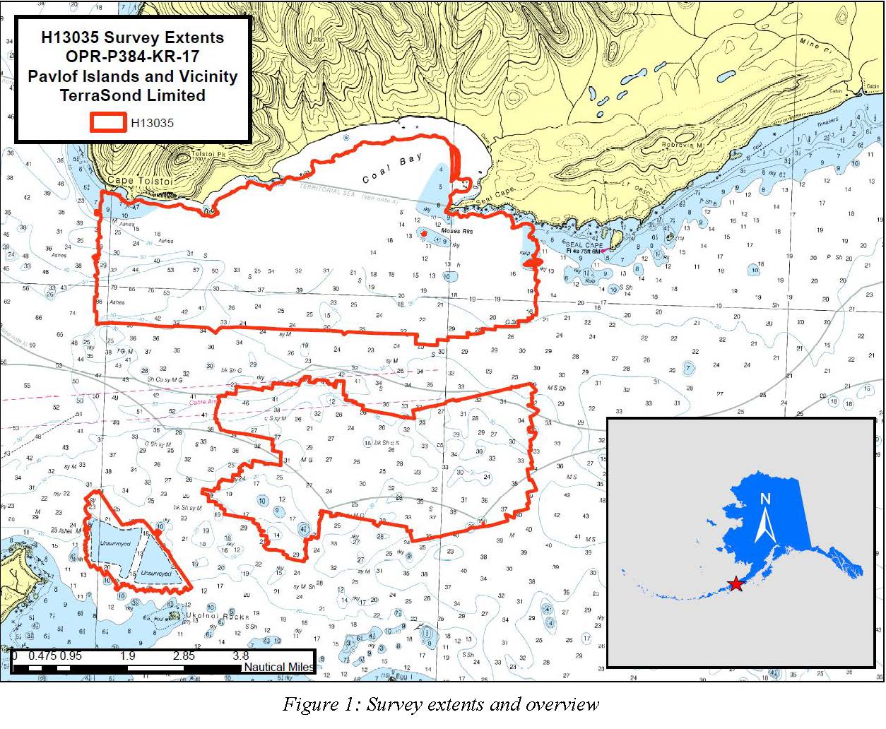
H13035: NOS Hydrographic Survey , Pavlof Islands and Vicinity, 2017-09-26
National Oceanic and Atmospheric Administration, Department of Commerce —
The National Oceanic and Atmospheric Administration (NOAA) has the statutory mandate to collect hydrographic data in support of nautical chart compilation for safe... -
State
Age of Generating Units of California's Power Plants
State of California —
This dataset contains charts which represent the mix of fuel types and age, by decade of initial operation, of all generating units within California-based power... -
University
Coal Mine Permit Boundaries
Earth Data Analysis Center, University of New Mexico —
ESRI ArcView shapefile depicting New Mexico coal mines permitted under the Surface Mining Control and Reclamation Act of 1977 (SMCRA), by either the NM Mining &... -
Federal
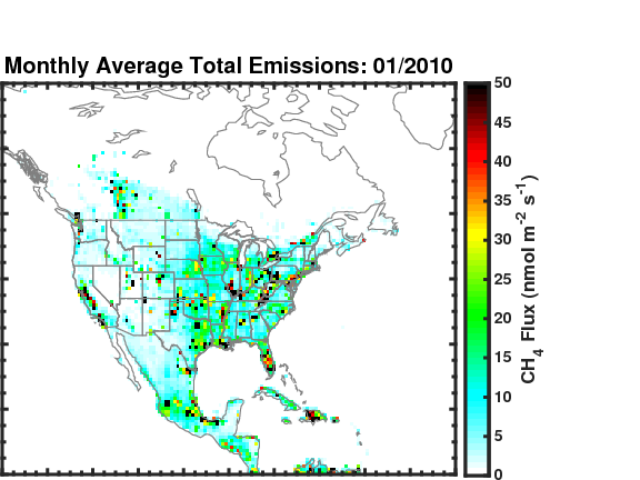
Methane (CH4) Flux for North America L4 Daily V1 (CMS_CH4_FLX_NAD) at GES DISC
National Aeronautics and Space Administration —
The CMS Methane (CH4) Flux for North America data set contains estimates of methane emission in North America based on an inversion of the GEOS-Chem chemical... -
Federal
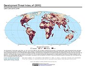
Development Threat Index
National Aeronautics and Space Administration —
The Development Threat Index data set is a terrestrial global, future development threat map based on combining these resources: agricultural expansion, urban... -
Federal
Global Inventory of Methane Emissions from Fuel Exploitation V1 (GFEI_CH4)
National Aeronautics and Space Administration —
This is a global inventory of methane emissions from fuel exploitation (GFEI) created for the NASA Carbon Monitoring System (CMS). The emission sources represented in... -
Federal
CMS (Carbon Monitoring System) Methane (CH4) Flux for North America 0.5 degree x 0.667 degree V1 (CMS_CH4_FLX_NA) at GES DISC
National Aeronautics and Space Administration —
An error was found in this product; therefore, it has been deleted. Please use the CMS Methane (CH4) Flux for North America Daily product (CMS_CH4_FLX_NAD) in its... -
Federal
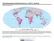
Global Development Potential Indices
National Aeronautics and Space Administration —
The Global Development Potential Indices (DPIs) data set contains thirteen sector-level DPIs for sectors related to renewable energy (concentrated solar power,... -
State
California Electrical Energy Generation
State of California —
Annual totals of electric production (in Gigawatt hours) by resource type. -
Federal
H11518: NOS Hydrographic Survey , Southwestern Alaskan Peninsula, Alaska, 2006-06-16
National Oceanic and Atmospheric Administration, Department of Commerce —
The National Oceanic and Atmospheric Administration (NOAA) has the statutory mandate to collect hydrographic data in support of nautical chart compilation for safe... -
Federal
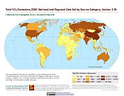
Anthropogenic Sulfur Dioxide Emissions, 1850-2005: National and Regional Data Set by Source Category, Version 2.86
National Aeronautics and Space Administration —
The Anthropogenic Sulfur Dioxide Emissions, 1850-2005: National and Regional Data Set by Source Category, Version 2.86 provides annual estimates of anthropogenic... -
Federal
Coal Point, Homer, AK, Tide Station (9455558)
National Oceanic and Atmospheric Administration, Department of Commerce —
Timeseries data from 'Coal Point, Homer, AK, Tide Station (9455558)' (coal-point-homer-ak-tide-stat)

Official websites use .gov
A
.gov website belongs to an official government
organization in the United States.
Secure .gov websites use HTTPS
A
lock (
) or https:// means you’ve safely connected to
the .gov website. Share sensitive information only on official,
secure websites.
.jpg)