
-
Federal
Global Navigation Satellite System (GNSS) Ionosphere Vertical Total Electron Content (VTEC) Final Product from NASA CDDIS
National Aeronautics and Space Administration —
This derived product set consists of Global Navigation Satellite System Final Ionosphere Vertical Total Electron Content (VTEC) product (daily files) from the NASA... -
Federal
Airborne Gravity: NGS' Gravity data for AS09 (2018) NGDA
National Oceanic and Atmospheric Administration, Department of Commerce —
Airborne gravity data for coastal Alaska collected in 2018 over 2 surveys. This data set is part of the Gravity for the Re-definition of the American Vertical Datum... -
Federal
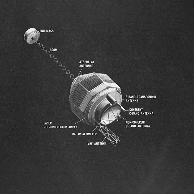
GEOS-3 Satellite-to-Satellite Tracking Data V001 (GEOS3STST) at GES DISC
National Aeronautics and Space Administration —
GEOS3STST is the satellite-to-satellite tracking data product which contains observations, obtained from the S-band transponders on GEOS 3 relayed by the ATS 6... -
Federal
Global Navigation Satellite System (GNSS) Rapid Clock Product (30 second resolution, daily files, generated daily) from NASA CDDIS
National Aeronautics and Space Administration —
This derived product set consists of Global Navigation Satellite System Rapid Satellite and Receiver Clock Product (30-second granularity, daily files, generated... -
Federal
Monthly Carbon Dioxide in Troposphere (AIRS on AQUA)
National Aeronautics and Space Administration —
Carbon dioxide (CO2) is an important greenhouse gas released through natural processes such as respiration and volcano eruptions and through huma activities such as... -
Federal
Airborne Gravity: NGS' Gravity Data for CS01 (2014)
National Oceanic and Atmospheric Administration, Department of Commerce —
Airborne gravity data for Alabama and Florida collected in 2008 over 1 survey. This data set is part of the Gravity for the Re-definition of the American Vertical... -
Federal
Ground-Based Meteorological Data (hourly files) from Co-Located Global Navigation Satellite System (GNSS) Receivers from NASA CDDIS
National Aeronautics and Space Administration —
This dataset consists of ground-based Meteorological Data (hourly, 24 hour files) from instruments co-located with Global Navigation Satellite System (GNSS) receivers... -
Federal
Ground-Based Global Navigation Satellite System Mixed Broadcast Ephemeris Data (sub-hourly files) from NASA CDDIS
National Aeronautics and Space Administration —
This dataset consists of ground-based Global Navigation Satellite System (GNSS) Mixed Broadcast Ephemeris Data (sub-hourly files) from the NASA Crustal Dynamics Data... -
Federal
Ground-Based Global Navigation Satellite System (GNSS) GPS real-time POD Attitude Quaternions (30-second sampling, 60-second files) from NASA CDDIS
National Aeronautics and Space Administration —
This product contains a time series of attitude quaternion components for healthy satellites in the GPS constellation that are accumulated every minute throughout the... -
Federal
Ground-Based Satellite Laser Ranging (SLR) Observation Data (normal points, daily, 24 hour files) from NASA CDDIS
National Aeronautics and Space Administration —
This dataset consists of ground-based Satellite Laser Ranging observation data (normal points, daily 24 hour files) from the NASA Crustal Dynamics Data Information... -
Federal
Ground-Based Global Navigation Satellite System (GNSS) GLONASS Broadcast Ephemeris Data (hourly files) from NASA CDDIS
National Aeronautics and Space Administration —
This dataset consists of ground-based Global Navigation Satellite System (GNSS) GLObal NAvigation Satellite System (GLONASS) Broadcast Ephemeris Data (hourly files)... -
Federal
Global Navigation Satellite System (GNSS) Ionosphere Vertical Total Electron Content (VTEC) Validation Product from NASA CDDIS
National Aeronautics and Space Administration —
This derived product set consists of Global Navigation Satellite System Ionosphere Vertical Total Electron Content (VTEC) comparison product (daily files) from the... -
Federal
Ground-Based Global Navigation Satellite System (GNSS) GLONASS Broadcast Ephemeris Data (daily files) from NASA CDDIS
National Aeronautics and Space Administration —
This dataset consists of ground-based Global Navigation Satellite System (GNSS) GLObal NAvigation Satellite System (GLONASS) Broadcast Ephemeris Data (daily files)... -
Federal
Ground-Based Global Navigation Satellite System (GNSS) Compact Observation Data (1-second sampling, sub-hourly files) from NASA CDDIS
National Aeronautics and Space Administration —
This dataset consists of ground-based Global Navigation Satellite System (GNSS) Observation Data (1-second sampling, sub-hourly files) from the NASA Crustal Dynamics... -
Federal
Ground-Based Global Navigation Satellite System (GNSS) Observation Data (1-second sampling, sub-hourly files) from NASA CDDIS
National Aeronautics and Space Administration —
This dataset consists of ground-based Global Navigation Satellite System (GNSS) Observation Data (1-second sampling, sub-hourly files) from the NASA Crustal Dynamics... -
Federal
Archive of NOAA Continuously Operating Reference Stations (CORS) Network (NCN)
National Oceanic and Atmospheric Administration, Department of Commerce —
The National Geodetic Survey's (NGS) NOAA Continuously Operating Reference Stations (CORS) Network (NCN) provides Global Navigation Satellite System (GNSS) data... -
Federal
GEOS-2 International Optical Beacon Data Input V001 (GEOS2OBSINPUTINTL) at GES DISC
National Aeronautics and Space Administration —
GEOS2OBSINPUTINTL is the optical beacon system data product which contains reduced raw geodetic optical observations obtained by various international camera systems.... -
Federal
Supporting Information for Satellite Laser Ranging (SLR) Data and Products from NASA CDDIS
National Aeronautics and Space Administration —
This dataset consists of ground-based Satellite Laser Ranging observation data (normal points, daily 24 hour files) from the NASA Crustal Dynamics Data Information... -
Federal
Global Navigation Satellite System (GNSS) Ionosphere Vertical Total Electron Content (VTEC) Comparison Product from NASA CDDIS
National Aeronautics and Space Administration —
This derived product set consists of Global Navigation Satellite System Ionosphere Vertical Total Electron Content (VTEC) comparison product (daily files) from the... -
Federal
Global Navigation Satellite System (GNSS) IGS Real-Time Combination Solution Summary of Real-Time AC Submissions from NASA CDDIS
National Aeronautics and Space Administration —
This derived product set consists of Global Navigation Satellite System satellite and receiver clock combination product (30-second granularity, daily files,...

Official websites use .gov
A
.gov website belongs to an official government
organization in the United States.
Secure .gov websites use HTTPS
A
lock (
) or https:// means you’ve safely connected to
the .gov website. Share sensitive information only on official,
secure websites.