
-
State
Zircon U-Pb and 40Ar/39Ar results from dikes collected within the Bruin Bay fault zone, lower Cook Inlet
State of Alaska —
This data release presents 40Ar/39Ar step-heating geochronology results from rocks collected roughly 7 km southwest of Contact Point, Iliamna B-3 Quadrangle. Samples... -
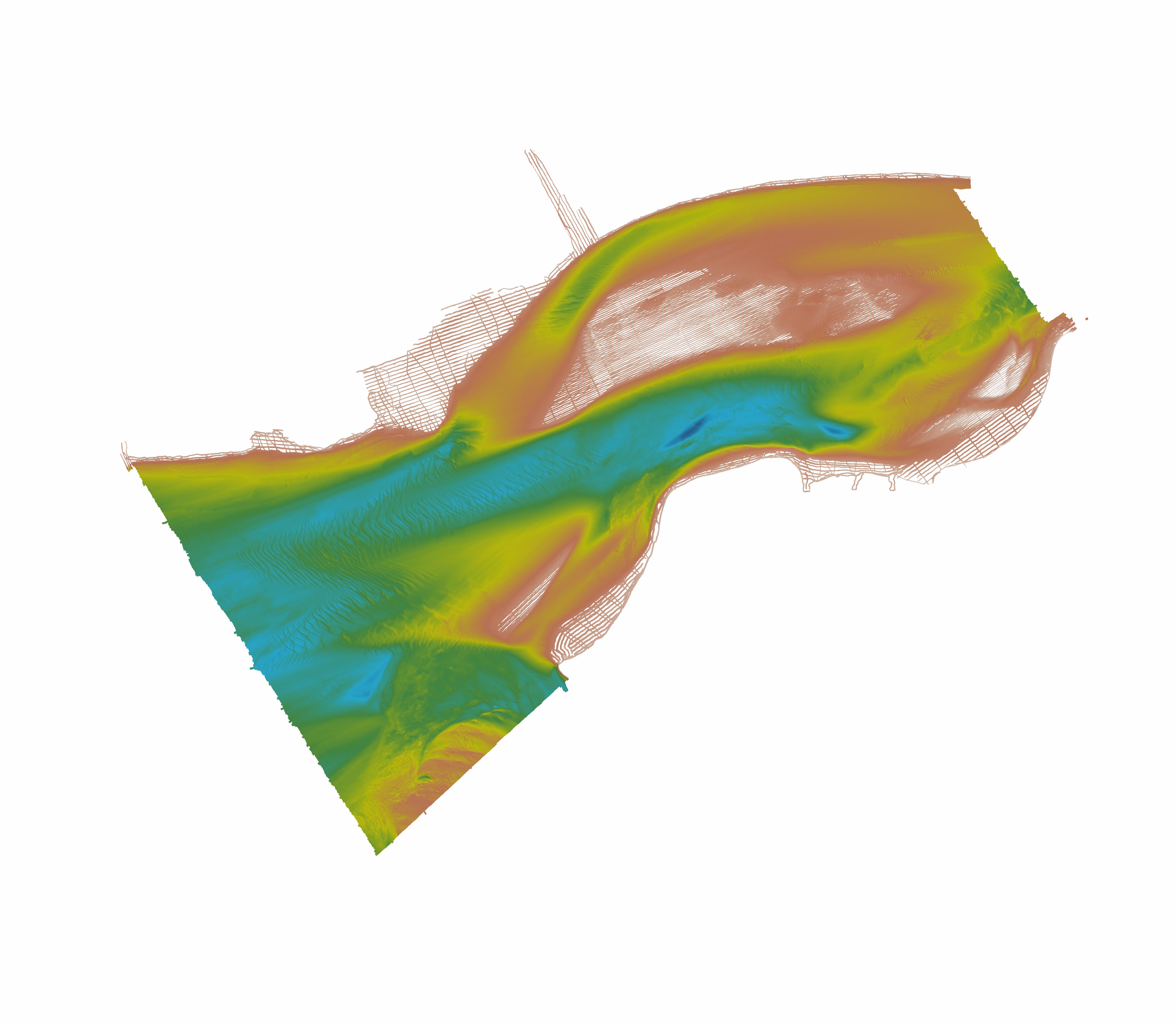
State
Lidar-derived elevation data for land near Grewingk Glacier and Halibut Cove Lagoon, Southcentral Alaska, collected October 12-13, 2021
State of Alaska —
Lidar-derived elevation data for land near Grewingk Glacier and Halibut Cove Lagoon, Southcentral Alaska, collected October 12-13, 2021, Raw Data File 2023-2, uses... -
State
A Guide to the Late Quaternary History of Northern and Western Kenai Peninsula, Alaska
State of Alaska —
Between 27 and 11 kyr ago, during the last major (Naptowne) glaciation, the northwestern and western Kenai Peninsula and the Cook Inlet trough were covered by ice... -
State
Geothermal Resources of Alaska
State of Alaska —
Between 1979 and 1982, the Alaska Division of Geological & Geophysical Surveys (DGGS) and the Geophysical Institute, University of Alaska Fairbanks, undertook an... -
State
Updated tsunami inundation maps for Homer and Seldovia, Alaska
State of Alaska —
We re-evaluate the potential tsunami hazard for the communities of Homer and Seldovia by numerically modeling the extent of inundation from tsunami waves generated by... -
State
Map of Alaska's coal resources
State of Alaska —
This data contains the location of coal resources within the State of Alaska and created in cooperation with the Alaska Coal Association. Total hypothetical coal... -
Federal
Cook Inlet, Alaska 3 arc-second Coastal Digital Elevation Model
National Oceanic and Atmospheric Administration, Department of Commerce —
NOAA's National Centers for Environmental Information (NCEI) is building high-resolution digital elevation models (DEMs) to support individual coastal States as part... -
State
Landslide hazard susceptibility mapping in Homer, Alaska
State of Alaska —
Landslide hazard susceptibility mapping in Homer, Alaska, Report of Investigation 2024-3, provides a map and database of historical and prehistoric slope failures,... -
Federal
Anchorage, Alaska 8/15 arc-second Coastal Digital Elevation Model
National Oceanic and Atmospheric Administration, Department of Commerce —
NOAA's National Centers for Environmental Information (NCEI) is building high-resolution digital elevation models (DEMs) to support individual coastal States as part... -
Federal
AFSC/RACE/GAP/Zimmermann: Cook Inlet Shoreline
National Oceanic and Atmospheric Administration, Department of Commerce —
We assembled 1.4 million National Ocean Service (NOS) bathymetric soundings from 98 lead-line and single-beam echosounder hydrographic surveys conducted from 1910 to... -
Federal
AFSC/NMML: Beluga whale aerial survey in Cook Inlet, Alaska, 1993-2022
National Oceanic and Atmospheric Administration, Department of Commerce —
The National Marine Fisheries Service (NMFS) has conducted aerial counts of Cook Inlet beluga whales (Delphinapterus leucas) from 1993 to 2012, 2014, 2016, 2018,... -
Federal
A Dataset from Bio-loggers Deployed on Harbor Seals (Phoca vitulina) in Cook Inlet, Alaska (2004-2007)
National Oceanic and Atmospheric Administration, Department of Commerce —
Between 2004 and 2006 we conducted four harbor seal tagging trips in Cook Inlet during the months of October and May. In total, we captured and released 93 harbor... -
Federal
AFSC/RACE/GAP/Zimmermann: Central Gulf of Alaska Grid
National Oceanic and Atmospheric Administration, Department of Commerce —
We assembled 1.75 million National Ocean Service (NOS) bathymetric soundings from 225 lead-line and single-beam echosounder hydrographic surveys conducted from 1901... -
State
Photogrammetry-derived historical orthoimagery for Homer, Alaska from 1951, 1952, 1964, and 1985
State of Alaska —
The State of Alaska Division of Geological & Geophysical Surveys (DGGS) used Structure-from-Motion (SfM) photogrammetry to produce orthoimagery for the City of... -
Federal
H03200: NOS Hydrographic Survey
National Oceanic and Atmospheric Administration, Department of Commerce —
The National Oceanic and Atmospheric Administration (NOAA) has the statutory mandate to collect hydrographic data in support of nautical chart compilation for safe... -
Federal
H10610: NOS Hydrographic Survey , Approaches to Nishkiski, Alaska, 1995-07-20
National Oceanic and Atmospheric Administration, Department of Commerce —
The National Oceanic and Atmospheric Administration (NOAA) has the statutory mandate to collect hydrographic data in support of nautical chart compilation for safe... -
Federal
H11249: NOS Hydrographic Survey , Cook Inlet, Alaska, 2004-10-29
National Oceanic and Atmospheric Administration, Department of Commerce —
The National Oceanic and Atmospheric Administration (NOAA) has the statutory mandate to collect hydrographic data in support of nautical chart compilation for safe... -
Federal
H10924: NOS Hydrographic Survey , Cook Inlet, Alaska, 1999-09-01
National Oceanic and Atmospheric Administration, Department of Commerce —
The National Oceanic and Atmospheric Administration (NOAA) has the statutory mandate to collect hydrographic data in support of nautical chart compilation for safe... -
Federal
H11248: NOS Hydrographic Survey , Cook Inlet, Alaska, 2004-10-29
National Oceanic and Atmospheric Administration, Department of Commerce —
The National Oceanic and Atmospheric Administration (NOAA) has the statutory mandate to collect hydrographic data in support of nautical chart compilation for safe...

Official websites use .gov
A
.gov website belongs to an official government
organization in the United States.
Secure .gov websites use HTTPS
A
lock (
) or https:// means you’ve safely connected to
the .gov website. Share sensitive information only on official,
secure websites.
.jpg)
.jpg)