
-
Federal
Global Man-made Impervious Surface (GMIS) Dataset From Landsat
National Aeronautics and Space Administration —
The Global Man-made Impervious Surface (GMIS) Dataset From Landsat consists of global estimates of fractional impervious cover derived from the Global Land Survey... -
Federal
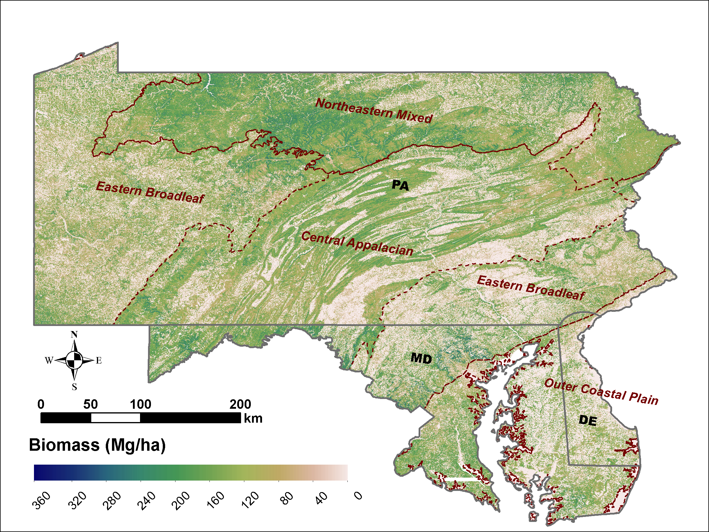
LiDAR Derived Biomass, Canopy Height and Cover for Tri-State (MD, PA, DE) Region, V2
National Aeronautics and Space Administration —
This dataset provides 30-meter gridded estimates of aboveground biomass (AGB), forest canopy height, and canopy coverage for Maryland, Pennsylvania, and Delaware in... -
Federal
COLLECTED STARDUST/NAVCAM SHAPE MODELS OF 81P/WILD 2, V2.1
National Aeronautics and Space Administration —
Shape models of comet 81P/Wild 2, as derived from the Stardust Navcam images obtained around the time of closest approach to the comet. Includes both the basic tri-... -
Federal
First ISCCP Regional Experiment (FIRE) Cirrus Phase II Colorado State University (CSU) Station 2 Data
National Aeronautics and Space Administration —
The First ISCCP Regional Experiments have been designed to improve data products and cloud/radiation parameterizations used in general circulation models (GCMs).... -
Federal
Making Predictions using Large Scale Gaussian Processes
National Aeronautics and Space Administration —
One of the key problems that arises in many areas is to estimate a potentially nonlinear function [tex] G(x, \theta)[/tex] given input and output samples [tex] ( X,y... -
Federal
COLLECTED STARDUST/NAVCAM SHAPE MODELS OF 81P/WILD 2, V2.0
National Aeronautics and Space Administration —
Shape models of comet 81P/Wild 2, as derived from the Stardust Navcam images obtained around the time of closest approach to the comet. Includes both the basic tri-... -
Federal
COLLECTED STARDUST/NAVCAM SHAPE MODELS OF 81P/WILD 2, V2.0
National Aeronautics and Space Administration —
Shape models of comet 81P/Wild 2, as derived from the Stardust Navcam images obtained around the time of closest approach to the comet. Includes both the basic tri-... -
Federal
LBA-ECO LC-02 Hot Pixel Fire Indicator Data for Tri-national MAP Region: 2003-2006 NGDA
National Aeronautics and Space Administration —
This data set provides hot pixel data, as an indicator of fires, that were detected by various satellites in the tri-national MAP region (Madre de Dios-Peru, Acre-... -
Federal
ETM+ PAN (1999-2003)
National Aeronautics and Space Administration —
Single scene Tri-Decadal Global Landsat Orthorectified MSS, TM, ETM+, and ETM+ Pan-sharpened data, which may be browsed, searched, and downloaded through... -
Federal
Amazon iNfluence on the Atlantic: CarbOn export from Nitrogen fixation by DiAtom Symbioses (ANACONDAS)
National Aeronautics and Space Administration —
This research project sutided the effects of the Amazon River plume on the carbon and nitrogen cycling of the western tropical North Atlantic Ocean. Phytoplankton... -
Federal
NPP Grassland: Tumentsogt, Mongolia, 1982-1990, R1
National Aeronautics and Space Administration —
This data set provides two data files in text format (.txt). One file contains tri-monthly measurements of above-ground biomass made during the growing season between... -
Federal
Thematic Mapper (TM) Mosaics (1984-1997)
National Aeronautics and Space Administration —
Mosaic data products, which are also available for Tri-Decadal Global Landsat Orthorectified TM and ETM+ Pan-sharpened data, and may be searched and downloaded... -
Federal
Global Human Built-up And Settlement Extent (HBASE) Dataset From Landsat
National Aeronautics and Space Administration —
The Global Human Built-up And Settlement Extent (HBASE) Dataset from Landsat is a global map of HBASE derived from the Global Land Survey (GLS) Landsat dataset for... -
Federal
VIIRS Plus DMSP Change in Lights (VIIRS+DMSP dLIGHT)
National Aeronautics and Space Administration —
The VIIRS Plus DMSP Change in Lights (VIIRS+DMSP dLIGHT) data set fuses nighttime lights imagery from the U.S. Air Force Defense Meteorological Satellite Program... -
Federal
Convergent Aeronautics Solutions Project
National Aeronautics and Space Administration —
The Convergent Aeronautics Solutions (CAS) Project uses short-duration activities to establish early-stage concept and technology feasibility for high-potential... -
Federal
HARV replication of the BRIC-23 Bacillus subtilis spaceflight
National Aeronautics and Space Administration —
Previous spaceflight experiments using Bacillus subtilis have reported altered transcriptome profiles during spaceflight compared to matching ground samples. This... -
Federal
SHIFT: Ramses Trios Radiometer Above Water Measurements, Santa Barbara Sea, CA
National Aeronautics and Space Administration —
This dataset provides calculated remote sensing reflectance (Rrs) from measurements collected with a Ramses TriOS radiometer deployed on the Santa Barbara Museum of... -
Federal
CLPX Airborne: Airborne Visible/Infrared Imaging Spectrometer (AVIRIS) Data, Version 1
National Aeronautics and Space Administration —
This data set consists of apparent surface reflectance, subpixel snow-covered area and grain size inferred from data acquired by the Airborne Visible/Infrared Imaging...

Official websites use .gov
A
.gov website belongs to an official government
organization in the United States.
Secure .gov websites use HTTPS
A
lock (
) or https:// means you’ve safely connected to
the .gov website. Share sensitive information only on official,
secure websites.