

43 datasets found for "Coal"
-
Federal
BLM CO RGFO AECRMP Coal Available Underground 20240108
Department of the Interior —
This layer originated from the Coal Unsuitability Analysis. The original dataset contained areas available for underground coal leasing in Alternatives B, C, and D.... -
Federal
Digital Geologic-GIS Map of Johnstown Flood National Memorial and portions of Allegheny Portage Railroad National Historic Site, Pennsylvania (NPS, GRD, GRI, JOFL, JOFL_ALPO digital map) adapted from a Pennsylvania Geological Survey Water Resource Report map by McElroy (1998)
Department of the Interior —
The Digital Geologic-GIS Map of Johnstown Flood National Memorial and portions of Allegheny Portage Railroad National Historic Site, Pennsylvania is composed of GIS... -
Federal
Digital Geologic-GIS Map of Greene County, Pennsylvania (NPS, GRD, GRI, FONE, FRHI, GRNC digital map) adapted from a Pennsylvania Geological Survey Water Resource Report map by Stoner, Williams, Buckwalter, Felbinger and Pattison (1987)
Department of the Interior —
The Digital Geologic-GIS Map of Greene County, Pennsylvania is composed of GIS data layers and GIS tables, and is available in the following GRI-supported GIS data... -
Federal
Digital Geologic-GIS Map of the Middlesboro North Quadrangle, Kentucky (NPS, GRD, GRI, CUGA, MBNO digital map) adapted from a Kentucky Geological Survey Digitally Vectorized Geological Quadrangle map by Sparks (2003) and a U.S. Geological Survey Geologic Quadrangle Map by Rice and Ping (1989)
Department of the Interior —
The Digital Geologic-GIS Map of the Middlesboro North Quadrangle, Kentucky is composed of GIS data layers and GIS tables, and is available in the following GRI-... -
Federal
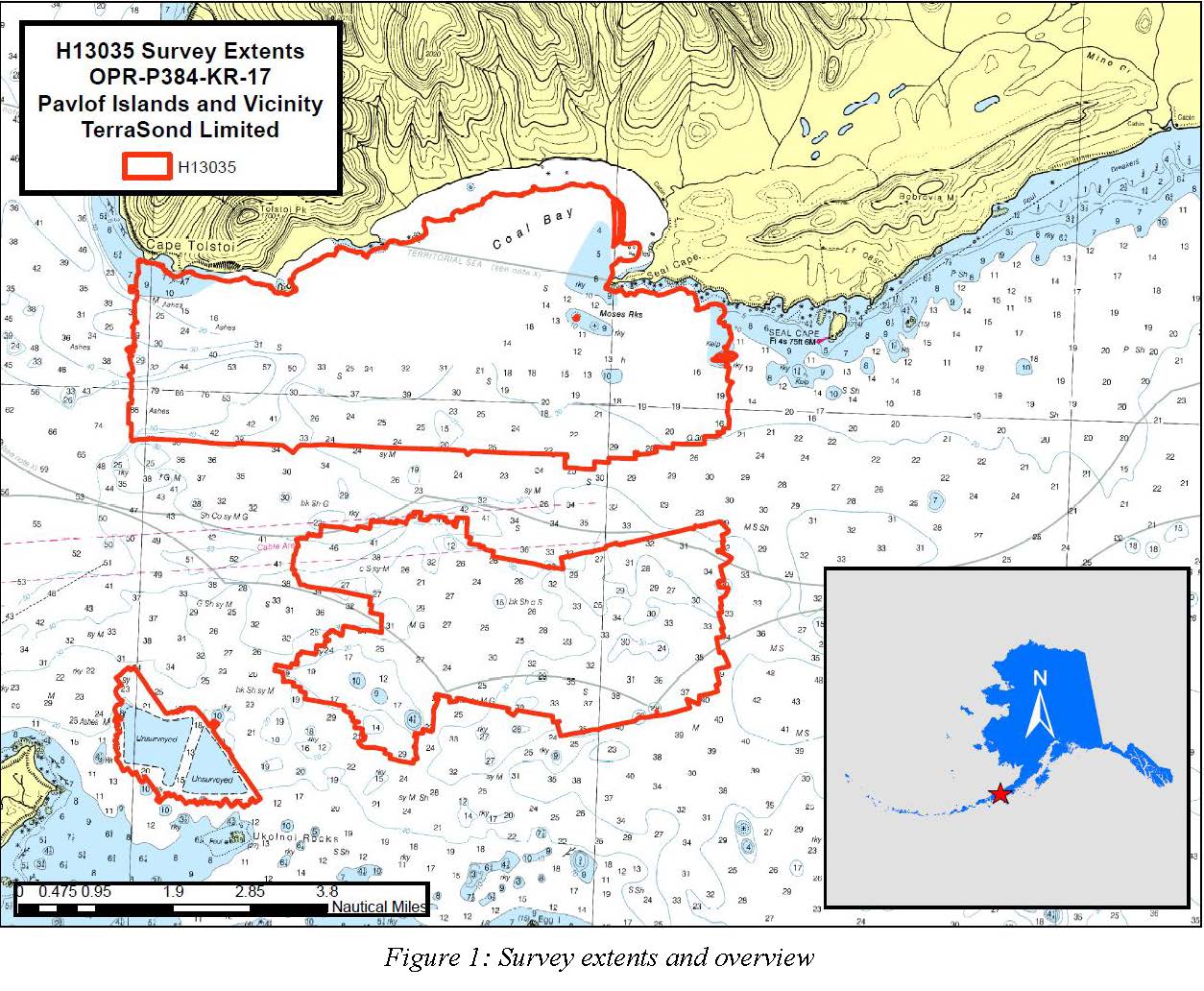
H13035: NOS Hydrographic Survey , Pavlof Islands and Vicinity, 2017-09-26
National Oceanic and Atmospheric Administration, Department of Commerce —
The National Oceanic and Atmospheric Administration (NOAA) has the statutory mandate to collect hydrographic data in support of nautical chart compilation for safe... -
Federal
Digital Geologic-GIS Map of Fayette County, Pennsylvania (NPS, GRD, GRI, FONE, FRHI, FACO digital map) adapted from a Pennsylvania Geological Survey Water Resource Report map by McElroy (1988)
Department of the Interior —
The Digital Geologic-GIS Map of Fayette County, Pennsylvania is composed of GIS data layers and GIS tables, and is available in the following GRI-supported GIS data... -
Federal
H11518: NOS Hydrographic Survey , Southwestern Alaskan Peninsula, Alaska, 2006-06-16
National Oceanic and Atmospheric Administration, Department of Commerce —
The National Oceanic and Atmospheric Administration (NOAA) has the statutory mandate to collect hydrographic data in support of nautical chart compilation for safe... -
Federal
Roadless Areas: Colorado Roadless Rule (Feature Layer)
Department of Agriculture —
This feature class describes the boundaries of Roadless Areas designated by the Colorado Roadless Rule of 2012 and managed by the US Forest Service. These roadless... -
Federal
BLM CO Big Game Corridor Decision Area
Department of the Interior —
The decision area includes all BLM public lands (including BLM Bankhead Jones Lands) and split-estate private, local government, and state lands (excluding lands with... -
Federal
BLM Colorado Federal Mineral Estate
Department of the Interior —
This data set is a result of compiling differing source materials of various vintages.Source material examples used to create and maintain dataset include: BLM 100k... -
Federal
BLM Natl MLRS Coal Cases
Department of the Interior —
This dataset contains coal cases derived from Legal Land Descriptions (LLD) contained in the US Bureau of Land Management's, BLM, Mineral and Land Record System(MLRS)... -
Federal
Digital Geologic-GIS Map of Fort Necessity National Battlefield and Friendship Hill National Historical Site and Vicinity, Pennsylvania (NPS, GRD, GRI, FONE, FRHI, FONE digital map) adapted from Pennsylvania Geological Survey Water Resource Report maps by McElroy (1988) and Stoner, Williams, Buckwalter, Felbinger, and Pattison (1987)
Department of the Interior —
The Digital Geologic-GIS Map of Fort Necessity National Battlefield and Friendship Hill National Historical Site and Vicinity, Pennsylvania is composed of GIS data... -
Federal
Digital Geologic-GIS Map of the Kayjay Quadrangle and Kentucky part of the Fork Ridge Quadrangle, Kentucky (NPS, GRD, GRI, CUGA, KAYJ digital map) adapted from a Kentucky Geological Survey Digitally Vectorized Geological Quadrangle map by Conley (2003) and a U.S. Geological Survey Geologic Quadrangle Map by Rice and Maughan (1978)
Department of the Interior —
The Digital Geologic-GIS Map of the Kayjay Quadrangle and Kentucky part of the Fork Ridge Quadrangle, Kentucky is composed of GIS data layers and GIS tables, and is... -
Federal
Digital Geologic-GIS Map of the Kentucky part of the Rose Hill Quadrangle, Kentucky (NPS, GRD, GRI, CUGA, ROHI digital map) adapted from a Kentucky Geological Survey Digitally Vectorized Geological Quadrangle map by Crawford (2003) and a U.S. Geological Survey Geologic Quadrangle Map by Maughan and Tazelaar (1973)
Department of the Interior —
The Digital Geologic-GIS Map of the Kentucky part of the Rose Hill Quadrangle, Kentucky is composed of GIS data layers and GIS tables, and is available in the... -
Federal
Digital Geologic-GIS Map of the Tennessee part of the Fork Ridge Quadrangle, Tennessee (NPS, GRD, GRI, CUGA, FORD digital map) adapted from a Tennessee Division of Geology Geologic Quadrangle Map by Kohl and Sykes (1991)
Department of the Interior —
The Digital Geologic-GIS Map of the Tennessee part of the Fork Ridge Quadrangle, Tennessee is composed of GIS data layers and GIS tables, and is available in the... -
Federal
TIGER/Line Shapefile, 2021, County, Coal County, OK, All Roads
U.S. Census Bureau, Department of Commerce —
The TIGER/Line shapefiles and related database files (.dbf) are an extract of selected geographic and cartographic information from the U.S. Census Bureau's Master... -
Federal
TIGER/Line Shapefile, 2023, County, Coal County, OK, Address Ranges Relationship File
U.S. Census Bureau, Department of Commerce —
The TIGER/Line shapefiles and related database files (.dbf) are an extract of selected geographic and cartographic information from the U.S. Census Bureau's Master... -
Federal
H11950: NOS Hydrographic Survey , California Coastal Mapping Program, California, 2008-09-02
National Oceanic and Atmospheric Administration, Department of Commerce —
The National Oceanic and Atmospheric Administration (NOAA) has the statutory mandate to collect hydrographic data in support of nautical chart compilation for safe... -
University
Coal Mine Permit Boundaries
Earth Data Analysis Center, University of New Mexico —
ESRI ArcView shapefile depicting New Mexico coal mines permitted under the Surface Mining Control and Reclamation Act of 1977 (SMCRA), by either the NM Mining &...
43 datasets found for "Coal"