
-
Federal
H02770A: NOS Hydrographic Survey
National Oceanic and Atmospheric Administration, Department of Commerce —
The National Oceanic and Atmospheric Administration (NOAA) has the statutory mandate to collect hydrographic data in support of nautical chart compilation for safe... -
Federal
H10165: NOS Hydrographic Survey , Southern California Coast, California, 1985-05-01
National Oceanic and Atmospheric Administration, Department of Commerce —
The National Oceanic and Atmospheric Administration (NOAA) has the statutory mandate to collect hydrographic data in support of nautical chart compilation for safe... -
Federal
H02769: NOS Hydrographic Survey
National Oceanic and Atmospheric Administration, Department of Commerce —
The National Oceanic and Atmospheric Administration (NOAA) has the statutory mandate to collect hydrographic data in support of nautical chart compilation for safe... -
Federal
H02770: NOS Hydrographic Survey
National Oceanic and Atmospheric Administration, Department of Commerce —
The National Oceanic and Atmospheric Administration (NOAA) has the statutory mandate to collect hydrographic data in support of nautical chart compilation for safe... -
Federal
CMS (Carbon Monitoring System) Methane (CH4) Flux for North America 0.5 degree x 0.667 degree V1 (CMS_CH4_FLX_NA) at GES DISC
National Aeronautics and Space Administration —
An error was found in this product; therefore, it has been deleted. Please use the CMS Methane (CH4) Flux for North America Daily product (CMS_CH4_FLX_NAD) in its... -
Federal
Digital Geologic-GIS Map of Johnstown Flood National Memorial and portions of Allegheny Portage Railroad National Historic Site, Pennsylvania (NPS, GRD, GRI, JOFL, JOFL_ALPO digital map) adapted from a Pennsylvania Geological Survey Water Resource Report map by McElroy (1998)
Department of the Interior —
The Digital Geologic-GIS Map of Johnstown Flood National Memorial and portions of Allegheny Portage Railroad National Historic Site, Pennsylvania is composed of GIS... -
Federal
Digital Geologic-GIS Map of Greene County, Pennsylvania (NPS, GRD, GRI, FONE, FRHI, GRNC digital map) adapted from a Pennsylvania Geological Survey Water Resource Report map by Stoner, Williams, Buckwalter, Felbinger and Pattison (1987)
Department of the Interior —
The Digital Geologic-GIS Map of Greene County, Pennsylvania is composed of GIS data layers and GIS tables, and is available in the following GRI-supported GIS data... -
Federal
Digital Geologic-GIS Map of the Middlesboro North Quadrangle, Kentucky (NPS, GRD, GRI, CUGA, MBNO digital map) adapted from a Kentucky Geological Survey Digitally Vectorized Geological Quadrangle map by Sparks (2003) and a U.S. Geological Survey Geologic Quadrangle Map by Rice and Ping (1989)
Department of the Interior —
The Digital Geologic-GIS Map of the Middlesboro North Quadrangle, Kentucky is composed of GIS data layers and GIS tables, and is available in the following GRI-... -
Federal
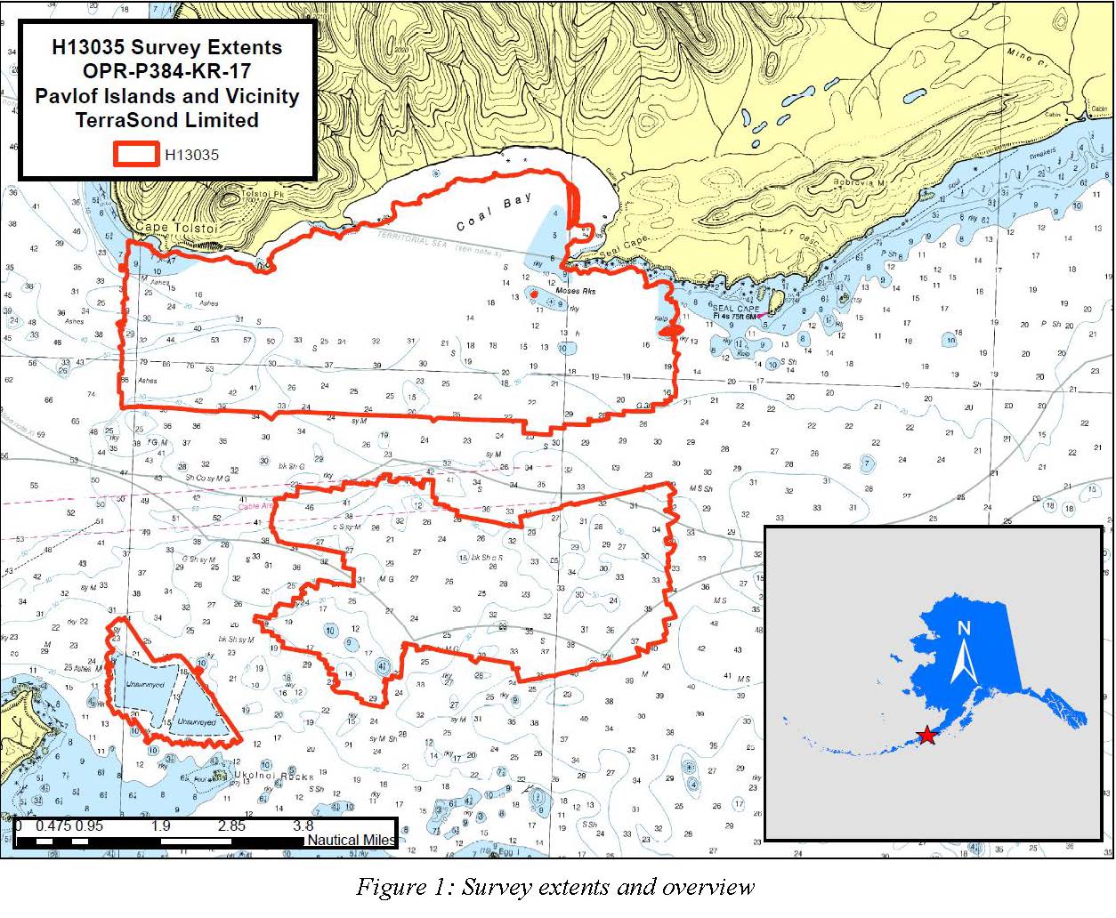
H13035: NOS Hydrographic Survey , Pavlof Islands and Vicinity, 2017-09-26
National Oceanic and Atmospheric Administration, Department of Commerce —
The National Oceanic and Atmospheric Administration (NOAA) has the statutory mandate to collect hydrographic data in support of nautical chart compilation for safe... -
Federal
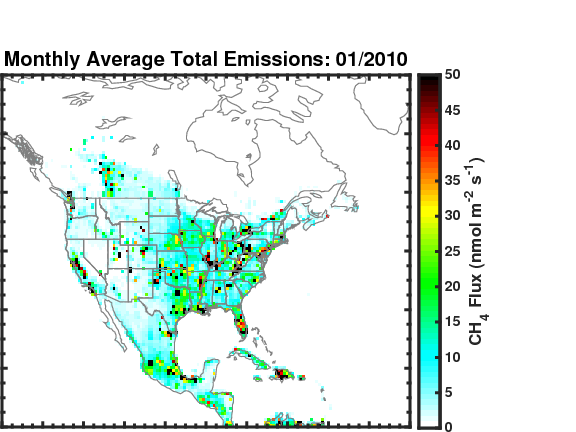
Methane (CH4) Flux for North America L4 Daily V1 (CMS_CH4_FLX_NAD) at GES DISC
National Aeronautics and Space Administration —
The CMS Methane (CH4) Flux for North America data set contains estimates of methane emission in North America based on an inversion of the GEOS-Chem chemical... -
Federal
Digital Geologic-GIS Map of Fayette County, Pennsylvania (NPS, GRD, GRI, FONE, FRHI, FACO digital map) adapted from a Pennsylvania Geological Survey Water Resource Report map by McElroy (1988)
Department of the Interior —
The Digital Geologic-GIS Map of Fayette County, Pennsylvania is composed of GIS data layers and GIS tables, and is available in the following GRI-supported GIS data... -
Federal
H11518: NOS Hydrographic Survey , Southwestern Alaskan Peninsula, Alaska, 2006-06-16
National Oceanic and Atmospheric Administration, Department of Commerce —
The National Oceanic and Atmospheric Administration (NOAA) has the statutory mandate to collect hydrographic data in support of nautical chart compilation for safe... -
Federal
Near-real-time surface ocean velocities derived from HF radar stations located along coastal waters of North Slope Alaska, Puerto Rico/Virgin Islands, eastern US/Gulf of Mexico, Hawaii and western US
National Oceanic and Atmospheric Administration, Department of Commerce —
This archival package contains near-real-time ocean surface velocities, also known as total vector velocities, derived from HF radar stations. The velocities are... -
Federal
Surface ocean velocities obtained by HF radar from stations located along coastal waters of Hawaii, North Slope Alaska, Puerto Rico/Virgin Islands, eastern US/Gulf of Mexico and western US
National Oceanic and Atmospheric Administration, Department of Commerce —
The National Data Buoy Center in collaboration with the Scripps Institution of Oceanography assembles the data from the Integrated Ocean Observing System Data... -
Federal
Mapping the spatial distribution of seepage activity in the Coal Oil Point seep field (COP1609, EK80)
National Oceanic and Atmospheric Administration, Department of Commerce —
A broad acoustic survey of the Coal Oil Point seep field was conducted using a small dive support vessel (R/V Connell) from the University of California â Santa... -
Federal
Measurements of natural hydrocarbon gas flux in the Coal Oil Point seep field (COP1710, EK80)
National Oceanic and Atmospheric Administration, Department of Commerce —
On 26 October 2017, acoustic data was collected in tandem with direct, in situ gas flux measurements. Acoustic data was collected using a Simrad ES200-7C split-beam... -
Federal
Global Inventory of Methane Emissions from Fuel Exploitation V1 (GFEI_CH4)
National Aeronautics and Space Administration —
This is a global inventory of methane emissions from fuel exploitation (GFEI) created for the NASA Carbon Monitoring System (CMS). The emission sources represented in... -
Federal
Digital Geologic-GIS Map of Fort Necessity National Battlefield and Friendship Hill National Historical Site and Vicinity, Pennsylvania (NPS, GRD, GRI, FONE, FRHI, FONE digital map) adapted from Pennsylvania Geological Survey Water Resource Report maps by McElroy (1988) and Stoner, Williams, Buckwalter, Felbinger, and Pattison (1987)
Department of the Interior —
The Digital Geologic-GIS Map of Fort Necessity National Battlefield and Friendship Hill National Historical Site and Vicinity, Pennsylvania is composed of GIS data... -
Federal
Digital Geologic-GIS Map of the Kayjay Quadrangle and Kentucky part of the Fork Ridge Quadrangle, Kentucky (NPS, GRD, GRI, CUGA, KAYJ digital map) adapted from a Kentucky Geological Survey Digitally Vectorized Geological Quadrangle map by Conley (2003) and a U.S. Geological Survey Geologic Quadrangle Map by Rice and Maughan (1978)
Department of the Interior —
The Digital Geologic-GIS Map of the Kayjay Quadrangle and Kentucky part of the Fork Ridge Quadrangle, Kentucky is composed of GIS data layers and GIS tables, and is...

Official websites use .gov
A
.gov website belongs to an official government
organization in the United States.
Secure .gov websites use HTTPS
A
lock (
) or https:// means you’ve safely connected to
the .gov website. Share sensitive information only on official,
secure websites.
.jpg)