
-
Federal
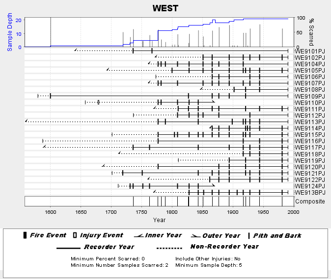
NOAA/WDS Paleoclimatology - Skinner fire data from WEST (San Pedro Martir) - IMPD MXWES001
National Oceanic and Atmospheric Administration, Department of Commerce —
This archived Paleoclimatology Study is available from the NOAA National Centers for Environmental Information (NCEI), under the World Data Service (WDS) for... -
Federal
FL Straights CICESE Mooring EFL5-T1030-A3L-NS3688-Z1020 (20120707-20130626)
National Oceanic and Atmospheric Administration, Department of Commerce —
Data for Florida Straights Moorings CICESE. A program aimed at measuring the flows between the Gulf of Mexico and the North Atlantic Ocean, from Cuba to Florida,... -
Federal
NOAA/WDS Paleoclimatology - Stahle - Cerro Baraja and Los Angeles Sawmill - PSME - ITRDB MEXI023
National Oceanic and Atmospheric Administration, Department of Commerce —
This archived Paleoclimatology Study is available from the NOAA National Centers for Environmental Information (NCEI), under the World Data Service (WDS) for... -
Federal
NOAA/WDS Paleoclimatology - Villanueva - Fule Cuevecillas - PSME - ITRDB MEXI080
National Oceanic and Atmospheric Administration, Department of Commerce —
This archived Paleoclimatology Study is available from the NOAA National Centers for Environmental Information (NCEI), under the World Data Service (WDS) for... -
Federal
FAST Eddy Sys 2 Transect 114, 150kHz kHz VMADCP
National Oceanic and Atmospheric Administration, Department of Commerce —
Program of vessel mount ADCP measurements comprising a combination of 75kHz and 150kHz ADCP data collected in the vicinity of the Loop Current and drilling blocks... -
Federal
CAGES_Texas_CPUE_Trawl_study_DATA_1987
National Oceanic and Atmospheric Administration, Department of Commerce —
Estuaries are important in supporting much of the fishery production in the Gulf of Mexico, but this support appears to vary widely among different estuarine systems.... -
Federal
Chromophoric Dissolved Organic Material, Aqua MODIS, NPP, Gulf of Mexico, 2002-2012 (8 Day Composite)
National Oceanic and Atmospheric Administration, Department of Commerce —
MODIS data is used to develop an index of the amount of chromophoric dissolved organic material (CDOM) in the surface waters. CDOM absorbs heavily in the blue... -
Federal
"Deepwater CTD - 88g0528d.ctd.nc - 27.0N, -94.75W - 1988-10-20"
National Oceanic and Atmospheric Administration, Department of Commerce —
The Minerals Management Service (MMS) of the U. S. Department of the Interior funded the Deepwater Physical Oceanography Reanalysis and Synthesis of Historical Data... -
Federal
NOAA/WDS Paleoclimatology - Stahle - Cerro Baraja and Los Angeles Sawmill - PSME - MEXI023, PAGES North America 2K Version
National Oceanic and Atmospheric Administration, Department of Commerce —
This archived Paleoclimatology Study is available from the NOAA National Centers for Environmental Information (NCEI), under the World Data Service (WDS) for... -
Federal
NOAA/WDS Paleoclimatology - Global Lake-Level Variations from 18,000 to 0 Years Ago: A Paleoclimatic Analysis
National Oceanic and Atmospheric Administration, Department of Commerce —
This archived Paleoclimatology Study is available from the NOAA National Centers for Environmental Information (NCEI), under the World Data Service (WDS) for... -
Federal
FAST Eddy Sys 2 Transect 88, 75kHz kHz VMADCP
National Oceanic and Atmospheric Administration, Department of Commerce —
Program of vessel mount ADCP measurements comprising a combination of 75kHz and 150kHz ADCP data collected in the vicinity of the Loop Current and drilling blocks... -
Federal
FAST Eddy Sys 2 Transect 163, 75kHz kHz VMADCP
National Oceanic and Atmospheric Administration, Department of Commerce —
Program of vessel mount ADCP measurements comprising a combination of 75kHz and 150kHz ADCP data collected in the vicinity of the Loop Current and drilling blocks... -
Federal
NCEP North American Regional Reanalysis (NARR), for 1979 to Present
National Oceanic and Atmospheric Administration, Department of Commerce —
The North America Regional Reanalysis (NARR) Project is a reanalysis of historical observations using a 32-km version of the National Centers for Environmental... -
Federal
Argo float vertical profile R4903238_061
National Oceanic and Atmospheric Administration, Department of Commerce —
These data are ocean profile data measured by profiling Argo S2A floats at a specific latitude, longitude, and date nominally from the surface to 2000 meters depth.... -
Federal
Walton-Smith CTD, WS18285, WS18285_WS18285_Stn.z04_610, 2018-10-15, 26.6373N 82.5892W
National Oceanic and Atmospheric Administration, Department of Commerce —
Walton-Smith Conductivity, Temperature, Depth (CTD) - WS18285 - WS18285_WS18285_Stn.z04_610 - 2018-10-15 - 26.6373N 82.5892W. Hydrographic Measurements in the Gulf of... -
Federal
Argo float vertical profile R4903238_038
National Oceanic and Atmospheric Administration, Department of Commerce —
These data are ocean profile data measured by profiling Argo S2A floats at a specific latitude, longitude, and date nominally from the surface to 2000 meters depth.... -
Federal
CAGES_Texas_CPUE_Trawl_study_DATA_1988
National Oceanic and Atmospheric Administration, Department of Commerce —
Estuaries are important in supporting much of the fishery production in the Gulf of Mexico, but this support appears to vary widely among different estuarine systems.... -
Federal
Argo float vertical profile R4903256_058
National Oceanic and Atmospheric Administration, Department of Commerce —
These data are ocean profile data measured by profiling Argo S2A floats at a specific latitude, longitude, and date nominally from the surface to 2000 meters depth.... -
Federal
Walton-Smith CTD, WS22281, WS22281_StnV5, 2022-10-11, 26.954N 82.7595W
National Oceanic and Atmospheric Administration, Department of Commerce —
Walton-Smith Conductivity, Temperature, Depth (CTD) - WS22281 - WS22281_StnV5 - 2022-10-11 - 26.954N 82.7595W. Hydrographic Measurements in the Gulf of Mexico. flags:... -
Federal
Argo float vertical profile R4903250_066
National Oceanic and Atmospheric Administration, Department of Commerce —
These data are ocean profile data measured by profiling Argo S2A floats at a specific latitude, longitude, and date nominally from the surface to 2000 meters depth....

Official websites use .gov
A
.gov website belongs to an official government
organization in the United States.
Secure .gov websites use HTTPS
A
lock (
) or https:// means you’ve safely connected to
the .gov website. Share sensitive information only on official,
secure websites.