
-
Federal
NACP North American Forest Dynamics Project: Forest Disturbance and Regrowth Data 19 recent views
National Aeronautics and Space Administration —
This data set provides the results of time-series analyses of Landsat imagery for 55 selected forested sites across the conterminous U.S.A. The output is a pair of... -
Federal
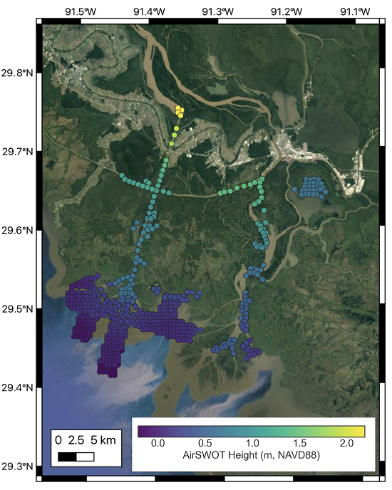
Delta-X: AirSWOT L2 Geocoded Water Surface Elevation, MRD, Louisiana, 2021, Version 2
National Aeronautics and Space Administration —
This dataset contains Level 2 (L2) AirSWOT geocoded products, including estimated water surface elevation. The AirSWOT instrument is a Ka-band interferometer and for... -
Federal
Delta-X: AirSWOT Level 1B Interferogram Products in Radar Coordinates, 2021
National Aeronautics and Space Administration —
This dataset contains AirSWOT interferogram products collected during the 2021 Delta-X Campaign over the Atchafalaya and Terrebonne Basins of the Mississippi River... -
Federal
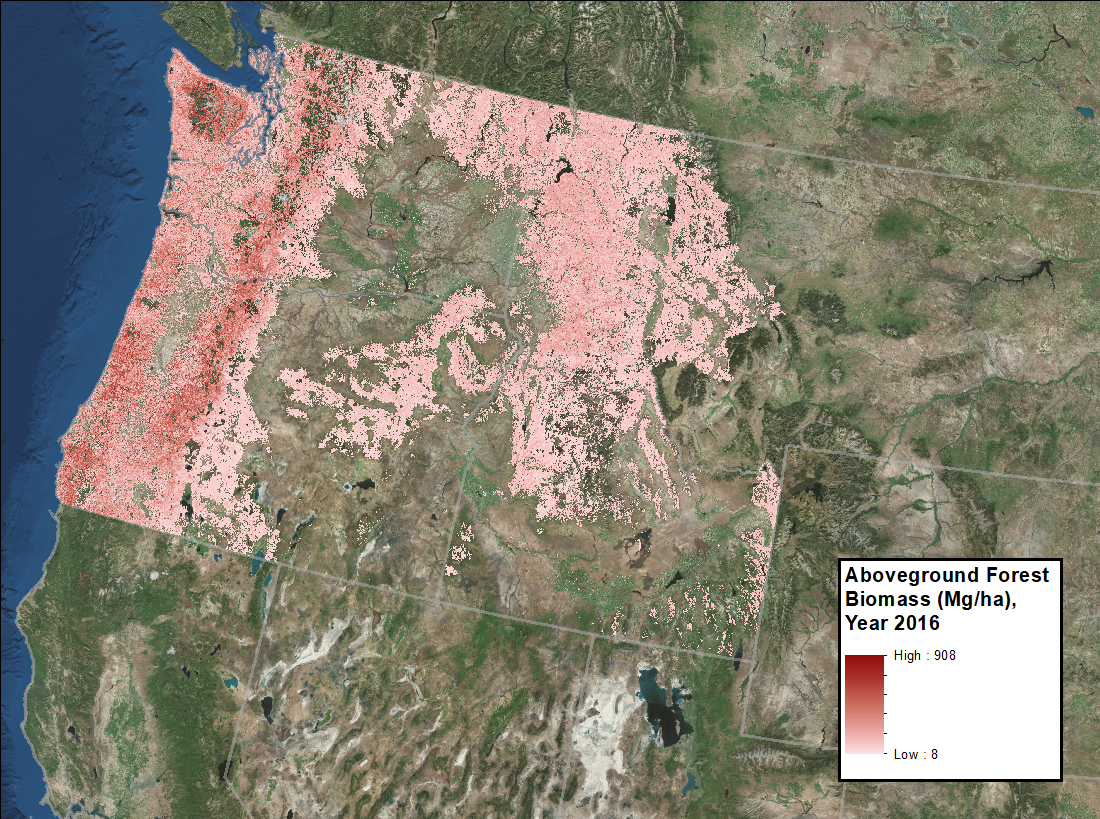
Annual Aboveground Biomass Maps for Forests in the Northwestern USA, 2000-2016
National Aeronautics and Space Administration —
This dataset provides annual maps of aboveground biomass (AGB, Mg/ha) for forests in Washington, Oregon, Idaho, and western Montana, USA, for the years 2000-2016, at... -
Federal
Pre-Delta-X: Channel Bathymetry of the Atchafalaya Basin, LA, USA, 2016
National Aeronautics and Space Administration —
This dataset provides water depths and water surface elevations collected during bathymetric surveys of the main channel of the Wax Lake Delta within the Mississippi... -
Federal
CMS: Mangrove Forest Cover Extent and Change across Major River Deltas, 2000-2016
National Aeronautics and Space Administration —
This dataset provides estimates of mangrove extent for 2016, and mangrove change (gain or loss) from 2000 to 2016, in major river delta regions of eight countries:... -
Federal
Delta-X: AirSWOT L3 Water Surface Elevations, MRD, Louisiana, 2021
National Aeronautics and Space Administration —
This dataset contains water surface elevations at selected point locations generated from the AirSWOT data collected during the Spring and Fall 2021 Delta-X... -
Federal
AfriSAR: Canopy Structure Derived from PolInSAR and Coherence TomoSAR NISAR tools
National Aeronautics and Space Administration —
This dataset contains forest vertical structure and associated uncertainty products derived by applying multi-baseline Polarimetric Interferometric Synthetic Aperture... -
Federal
ABoVE: Wetland Inundation Coverage at Yukon Flats, AK and PA Delta, Canada, 2017-2019
National Aeronautics and Space Administration —
This dataset provides time series of wetland inundation coverage maps and corresponding inundation frequency maps at ~10-meter resolution estimated every 12 days... -
Federal
NACP Regional: Original Observation Data and Biosphere and Inverse Model Outputs
National Aeronautics and Space Administration —
This data set contains the originally-submitted observation measurement data, terrestrial biosphere model output data, and inverse model simulations that various... -
Federal
ABoVE: TVPRM Simulated Net Ecosystem Exchange, Alaskan North Slope, 2008-2017 NGDA
National Aeronautics and Space Administration —
This dataset includes hourly net ecosystem exchange (NEE) simulated by the Tundra Vegetation Photosynthesis and Respiration Model (TVPRM) at 30 km horizontal... -
Federal
BOREAS TE-06 Multiband Vegetation Imager Data
National Aeronautics and Space Administration —
Describes the average data values derived from the multi-vegetation imager used by TE-06 during the BOREAS project.Describes the single point data values derived from... -
Federal
BOREAS RSS-17 Stem, Soil, and Air Temperature Data
National Aeronautics and Space Administration —
Contains the soil and stem temperature measurements collected by RSS17 at various flux sites: (1) Southern Study Area (SSA) at the Old Black Spruce (OBS), Old Jack... -
Federal
LUH2-ISIMIP2b Harmonized Global Land Use for the Years 2015-2100
National Aeronautics and Space Administration —
This dataset provides 0.25-degree gridded, global, annual estimates of fractional land use and land cover patterns for the period 2015-2100, designed to support the... -
Federal
LBA-ECO LC-07 Validation Overflight for Amazon Mosaics, Raster, 1999
National Aeronautics and Space Administration —
This data set includes high-resolution geocoded mosaics derived from the Validation Overflight for Amazon Mosaics (VOAM) aerial video surveys as part of the Large-... -
Federal
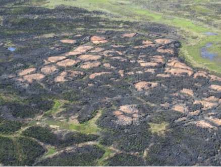
ABoVE: Post-Fire and Unburned Field Site Data, Anaktuvuk River Fire Area, 2008-2017
National Aeronautics and Space Administration —
This dataset includes field measurements from 26 burned and unburned transects established in 2008 in the region of the Anaktuvuk River tundra fire on the Arctic... -
Federal
LBA-ECO LC-24 Forest Cover Map from MODIS, 500-m, South America: 2001 NGDA
National Aeronautics and Space Administration —
This data set, LBA-ECO LC-24 Forest Cover Map from MODIS, 500-m, South America: 2001, contains forest cover information for 2001 for all of South America. The data... -
Federal
Global Peatland Carbon Balance and Land Use Change CO2 Emissions Through the Holocene
National Aeronautics and Space Administration —
This data set provides a time series of global peatland carbon balance and carbon dioxide emissions from land use change throughout the Holocene (the past 11,000... -
Federal
BOREAS TE-08 Aspen Bark Chemistry Data
National Aeronautics and Space Administration —
Contains bark biochemical data collected by TE-08. -
Federal
BOREAS TE-09 Leaf Biochemistry Averages
National Aeronautics and Space Administration —
Contains values of canopy biochemistry derived by the TE-09 team.

Official websites use .gov
A
.gov website belongs to an official government
organization in the United States.
Secure .gov websites use HTTPS
A
lock (
) or https:// means you’ve safely connected to
the .gov website. Share sensitive information only on official,
secure websites.