
-
Federal
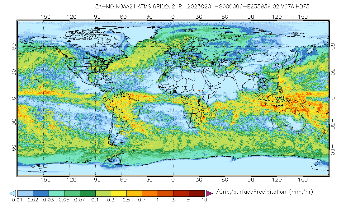
GPM ATMS on NOAA-21 (GPROF) Radiometer Precipitation Profiling L3 1 month 0.25 degree x 0.25 degree V07 (GPM_3GPROFNOAA21ATMS) at GES DISC
National Aeronautics and Space Administration —
Version 07 is the current version of the data set. 3GPROF products provide global gridded monthly/daily precipitation averages from multiple satellites that can be... -
Federal
GPM ATMS on NOAA-21 (GPROF) Climate-based Radiometer Precipitation Profiling L3 1 day 0.25 degree x 0.25 degree V07 (GPM_3GPROFNOAA21ATMS_DAY_CLIM) at GES DISC
National Aeronautics and Space Administration —
Version 07 is the current version of the data set. Older versions are no longer available and have been superseded by Version 07. The "CLIM" products differ from... -
Federal
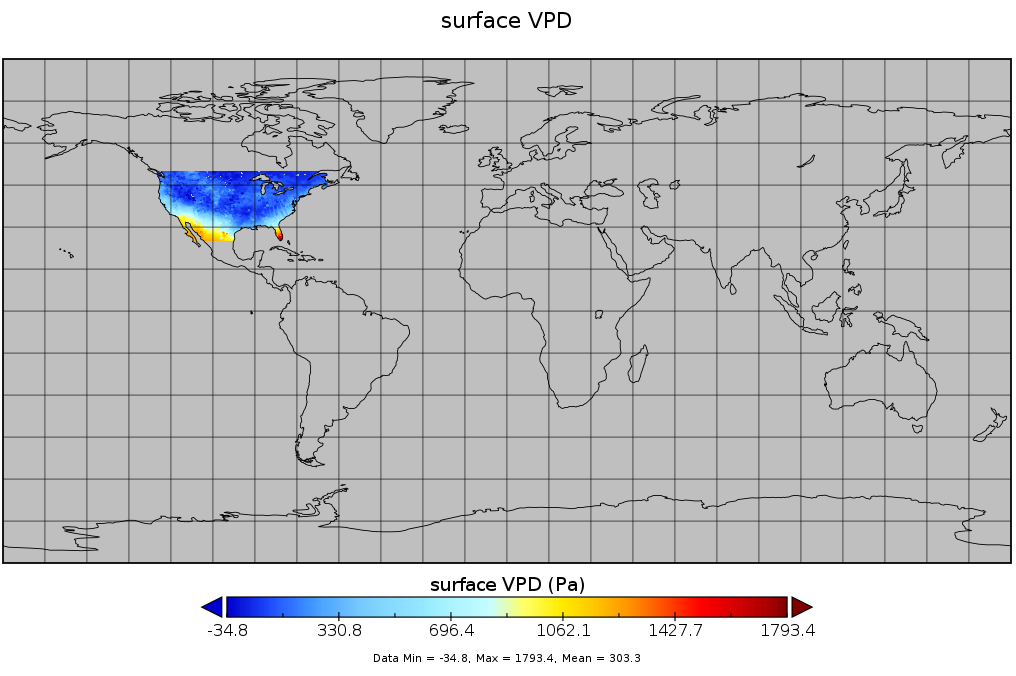
Spatial Statistical Data Fusion (SSDF) Level 3: CONUS Near-Surface Vapor Pressure Deficit from SNPP CrIMSS and Aqua AIRS, V2 (SNDR13IML3SSDFCVPD)
National Aeronautics and Space Administration —
The Spatial Statistical Data Fusion (SSDF) surface continental United States (CONUS) products, fuse data from the Atmospheric InfraRed Sounder (AIRS) instrument on... -
Federal
GPM ATMS on NOAA-21 (GPROF) Radiometer Precipitation Profiling L2A 1.5 hours 17 km V07 (GPM_2AGPROFNOAA21ATMS) at GES DISC
National Aeronautics and Space Administration —
Version 07 is the current version of the data set. The 2AGPROF (also known as, GPM GPROF (Level 2)) algorithm retrieves consistent precipitation and related science... -
Federal
GLDAS Catchment Land Surface Model L4 daily 0.25 x 0.25 degree GRACE-DA1 V2.2 (GLDAS_CLSM025_DA1_D) at GES DISC
National Aeronautics and Space Administration —
NASA Global Land Data Assimilation System Version 2 (GLDAS-2) has three components: GLDAS-2.0, GLDAS-2.1, and GLDAS-2.2. GLDAS-2.0 is forced entirely with the... -
Federal
GLDAS Catchment Land Surface Model L4 daily 0.25 x 0.25 degree GRACE-DA1 V2.2 (GLDAS_CLSM025_DA1_D_EP) at GES DISC
National Aeronautics and Space Administration —
NASA Global Land Data Assimilation System Version 2 (GLDAS-2) has three components: GLDAS-2.0, GLDAS-2.1, and GLDAS-2.2. GLDAS-2.0 is forced entirely with the... -
Federal
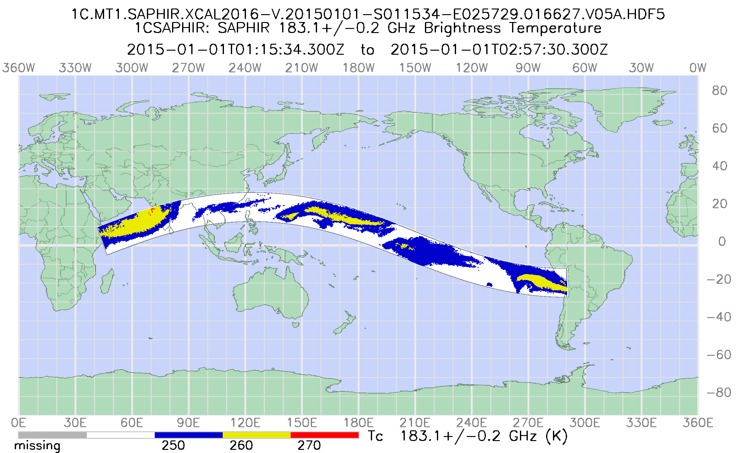
GPM SAPHIR on MT1 Common Calibrated Brightness Temperature L1C 1.5 hours 10 km V07 (GPM_1CMT1SAPHIR) at GES DISC
National Aeronautics and Space Administration —
Version 07 is the current version of the data set. Older versions will no longer be available and have been superseded by Version 07. 1CAMSR2 contains common... -
Federal
GPM ATMS on NOAA-21 (GPROF) Climate-based Radiometer Precipitation Profiling L2A 1.5 hours 17 km V07 (GPM_2AGPROFNOAA21ATMS_CLIM) at GES DISC
National Aeronautics and Space Administration —
Version 07 is the current version of the data set. The "CLIM" products differ from their "regular" counterparts (without the "CLIM" in the name) by the ancillary data... -
Federal
GPM ATMS on NOAA-21 (GPROF) Climate-based Radiometer Precipitation Profiling L3 1 month 0.25 degree x 0.25 degree V07 (GPM_3GPROFNOAA21ATMS_CLIM) at GES DISC
National Aeronautics and Space Administration —
Version 07 is the current version of the data set. Older versions are no longer available and have been superseded by Version 07. The "CLIM" products differ from... -
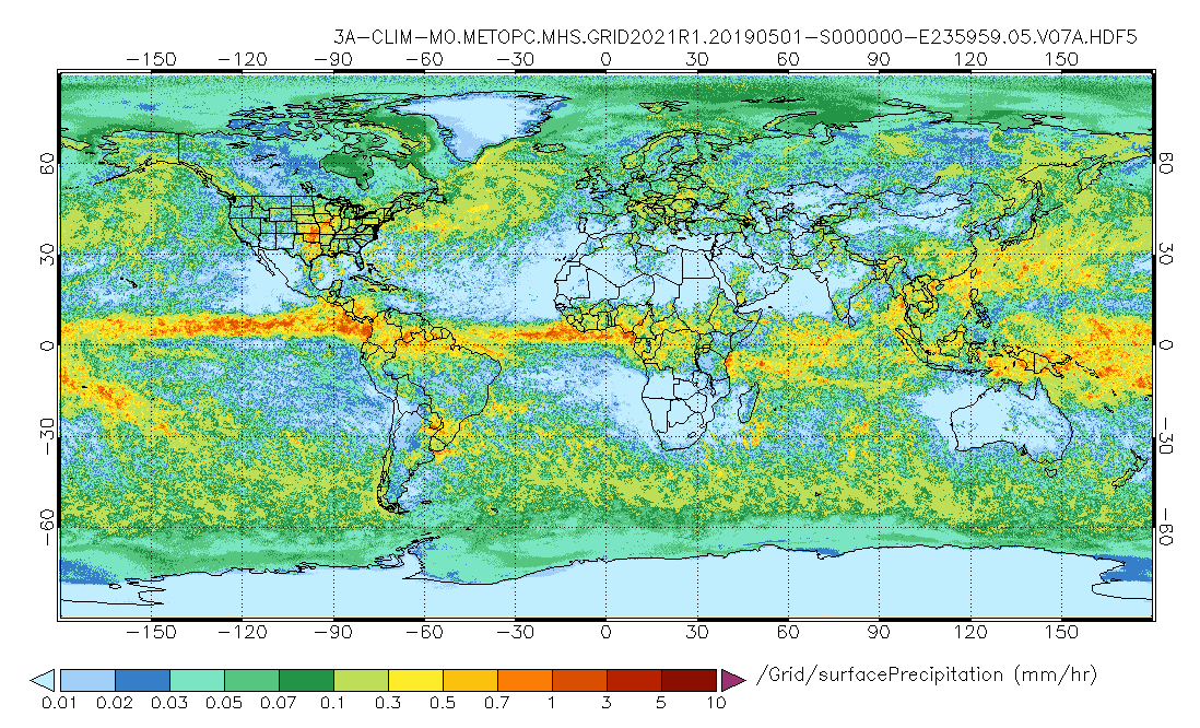
Federal
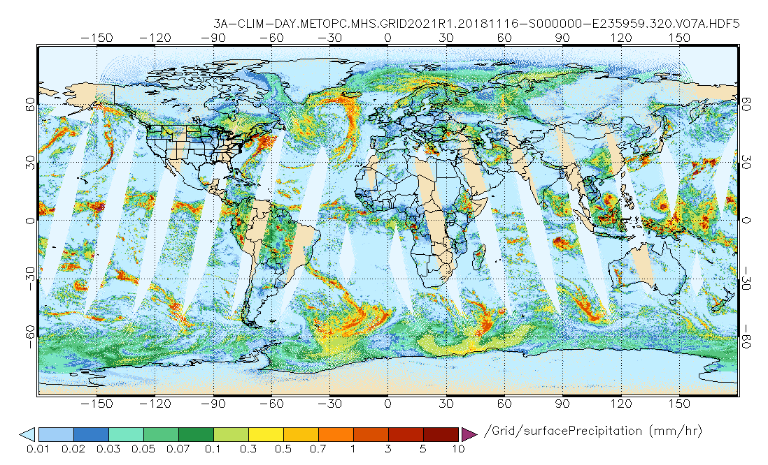
GPM MHS on METOP-C (GPROF) Climate-based Radiometer Precipitation Profiling L3 1 day 0.25 degree x 0.25 degree V07 (GPM_3GPROFMETOPCMHS_DAY_CLIM) at GES DISC
National Aeronautics and Space Administration —
Version 07 is the current version of the data set. Older versions are no longer available and have been superseded by Version 07. The "CLIM" products differ from... -
Federal
GPM DPR and GMI Combined Convective Stratiform Heating L3 1 month 0.5 degree x 0.5 degree V07 (GPM_3HCSH) at GES DISC
National Aeronautics and Space Administration —
The Gridded Convective Stratiform Heating (3HCSH) products contain latent heating, Q1-QR and Q2 profiles from DPR raindata. Version 07 is the current version of the... -
Federal
ATMOS L2 Trace Gases on Potential Temperature Grid, Tab Delimited Format V3 (ATMOSL2TT) at GES DISC
National Aeronautics and Space Administration —
This is the version 3 Atmospheric Trace Molecule Spectroscopy (ATMOS) Level 2 product containing trace gases on a vertical potential temperature (theta) grid with... -
Federal
GPM MHS on METOP-C Common Calibrated Brightness Temperature L1C 1.5 hours 17 km V07 (GPM_1CMETOPCMHS) at GES DISC
National Aeronautics and Space Administration —
Version 07 is the current version of the data set. 1CAMSR2 contains common calibrated brightness temperature from the AMSR2 passive microwave instrument flown on the... -
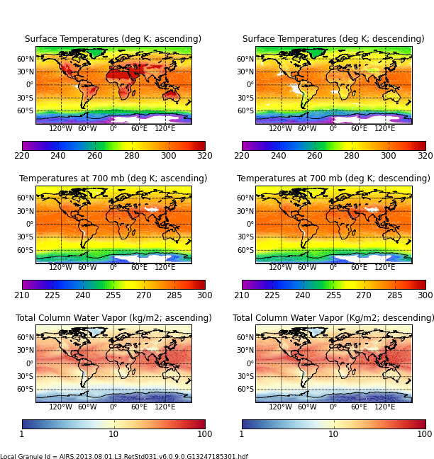
Federal
AIRS/Aqua L3 Monthly Standard Physical Retrieval (AIRS+AMSU) 1 degree x 1 degree V006 (AIRX3STM) at GES DISC
National Aeronautics and Space Administration —
The Atmospheric Infrared Sounder (AIRS) is a grating spectrometer (R = 1200) aboard the second Earth Observing System (EOS) polar-orbiting platform, EOS Aqua. In... -
Federal
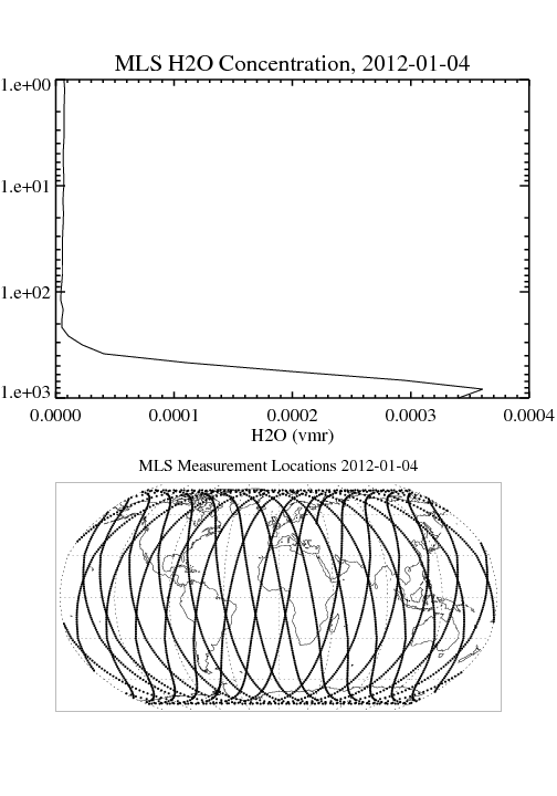
MLS/Aura Level 2 Water Vapor (H2O) Mixing Ratio V004 (ML2H2O) at GES DISC
National Aeronautics and Space Administration —
ML2H2O is the EOS Aura Microwave Limb Sounder (MLS) standard product for water vapor derived from radiances measured primarily by the 190 GHz radiometer. The data... -
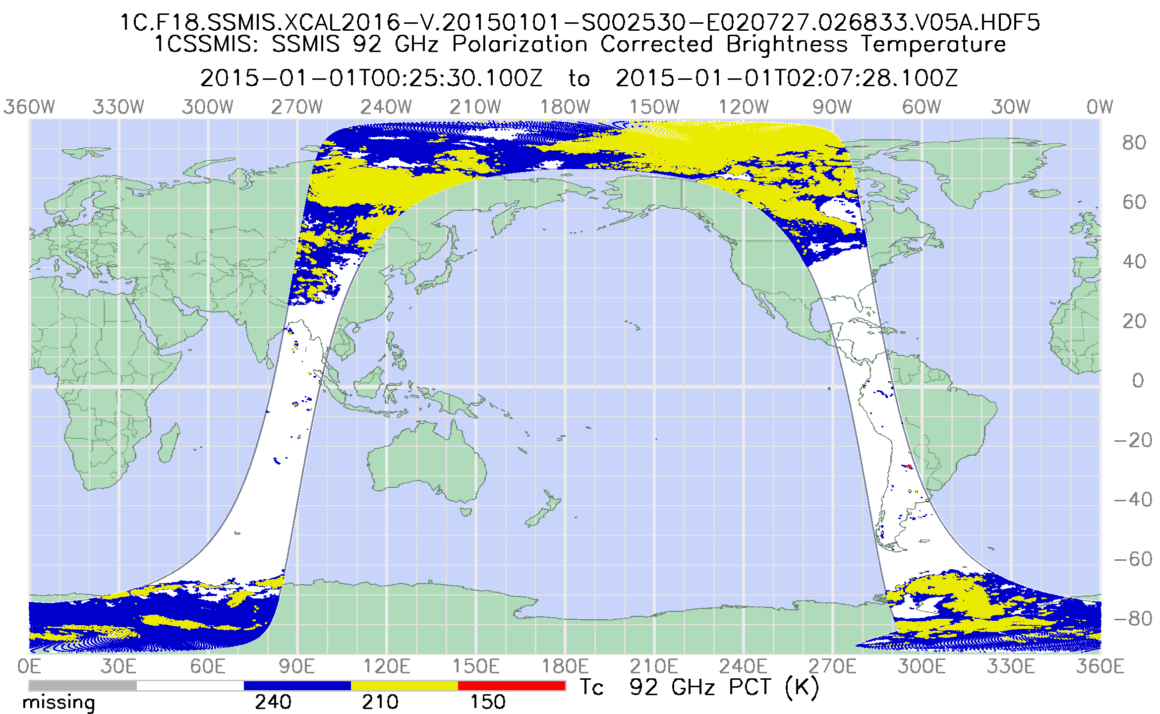
Federal
GPM SSMIS on F18 Common Calibrated Brightness Temperatures L1C 1.5 hours 12 km V07 (GPM_1CF18SSMIS) at GES DISC
National Aeronautics and Space Administration —
Version 07 is the current version of the data set. Older versions will no longer be available and have been superseded by Version 07. All 1C products have a common... -
Federal
GPM MHS on METOP-C (GPROF) Climate-based Radiometer Precipitation Profiling L3 1 month 0.25 degree x 0.25 degree V07 (GPM_3GPROFMETOPCMHS_CLIM) at GES DISC
National Aeronautics and Space Administration —
Version 07 is the current version of the data set. Older versions are no longer available and have been superseded by Version 07. The "CLIM" products differ from... -
Federal
TOVS GLA 5 DAY GRIDS from NOAA-10 V01 (TOVSA5NG) at GES DISC
National Aeronautics and Space Administration —
This dataset (TOVSA5NG) contains the TIROS Operational Vertical Sounder (TOVS) level 3 geophysical parameters derived using data from NOAA-10 and the physical... -
Federal
GPM ATMS on NOAA-21 Common Calibrated Brightness Temperatures L1C 1.5 hours 17 km V07 (GPM_1CNOAA21ATMS) at GES DISC
National Aeronautics and Space Administration —
Version 07 is the current version of the data set. Older versions will no longer be available and have been superseded by Version 07. 1CATMS contains common... -
Federal
GPM MHS on METOP-A (GPROF) Radiometer Precipitation Profiling L3 1 day 0.25 degree x 0.25 degree V07 (GPM_3GPROFMETOPAMHS_DAY_CLIM) at GES DISC
National Aeronautics and Space Administration —
Version 07 is the current version of the data set. Older versions are no longer available and have been superseded by Version 07. The "CLIM" products differ from...

Official websites use .gov
A
.gov website belongs to an official government
organization in the United States.
Secure .gov websites use HTTPS
A
lock (
) or https:// means you’ve safely connected to
the .gov website. Share sensitive information only on official,
secure websites.