
-
Federal
TROPESS CrIS-SNPP L2 Peroxyacetyl Nitrate for West Coast Fires, Standard Product V1 (TRPSDL2PANCRSWCF) at GES DISC
National Aeronautics and Space Administration —
The TROPESS CrIS-SNPP L2 Peroxyacetyl Nitrate for West Coast Fires, Standard Product contains the vertical distribution of the retrieved atmospheric state of... -
Federal
Sentinel-5P TROPOMI Total Ozone Column 1-Orbit L2 7km x 3.5km V1 (S5P_L2__O3_TOT) at GES DISC
National Aeronautics and Space Administration —
Starting from August 6th in 2019, Sentinel-5P TROPOMI along-track high spatial resolution (~5.5km at nadir) has been implemented. Starting from July 13th in 2020,... -
Federal
TRMM Radar Rain Distributions L3 1 month 5 degree x 5 degree V7 (TRMM_3A26) at GES DISC
National Aeronautics and Space Administration —
The new version of these data is in GPM-like format (consistent with the GPM Dual-frequency Radar data format), and can be found under the name GPM_3PR. This dataset... -
Federal
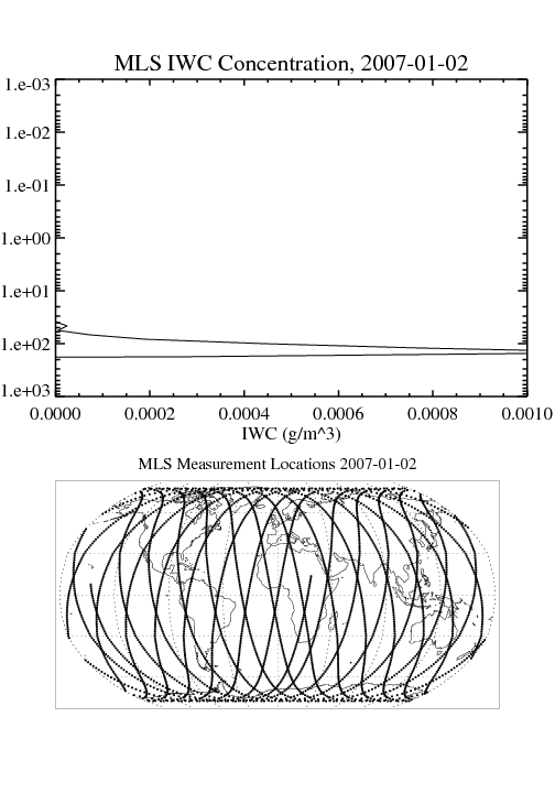
MLS/Aura Level 2 Cloud Ice Product V004 (ML2IWC) at GES DISC
National Aeronautics and Space Administration —
ML2IWC is the EOS Aura Microwave Limb Sounder (MLS) standard product for cloud ice water content derived from radiances measured by the 240 GHz radiometer. The data... -
Federal
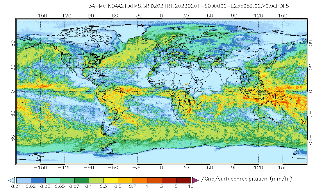
GPM ATMS on NOAA-21 (GPROF) Radiometer Precipitation Profiling L3 1 month 0.25 degree x 0.25 degree V07 (GPM_3GPROFNOAA21ATMS) at GES DISC
National Aeronautics and Space Administration —
Version 07 is the current version of the data set. 3GPROF products provide global gridded monthly/daily precipitation averages from multiple satellites that can be... -
Federal
GPM ATMS on NOAA-21 (GPROF) Climate-based Radiometer Precipitation Profiling L3 1 day 0.25 degree x 0.25 degree V07 (GPM_3GPROFNOAA21ATMS_DAY_CLIM) at GES DISC
National Aeronautics and Space Administration —
Version 07 is the current version of the data set. Older versions are no longer available and have been superseded by Version 07. The "CLIM" products differ from... -
Federal
TROPESS AIRS-Aqua L2 Methane for Forward Stream, Standard Product V1 (TRPSDL2CH4AIRSFS) at GES DISC
National Aeronautics and Space Administration —
The TROPESS AIRS-Aqua L2 Methane for Forward Stream, Standard Product contains the vertical distribution of the retrieved atmospheric state of methane (CH4), formal... -
Federal
Sentinel-5P TROPOMI Radiance product band 8 (SWIR detector) L1B 5.5km x 7km V2 (S5P_L1B_RA_BD8_HiR) at GES DISC
National Aeronautics and Space Administration —
Starting from August 6th in 2019, Sentinel-5P TROPOMI along-track high spatial resolution (~5.5km at nadir) has been implemented. For data before August 6th of 2019,... -
Federal
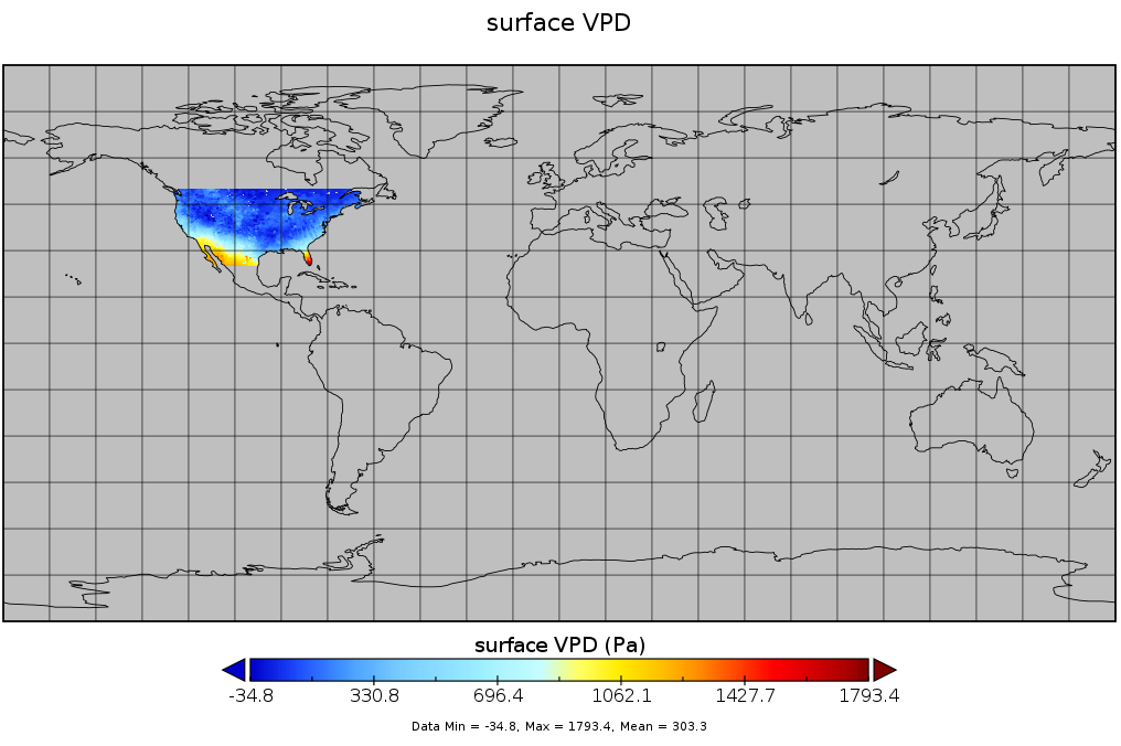
Spatial Statistical Data Fusion (SSDF) Level 3: CONUS Near-Surface Vapor Pressure Deficit from SNPP CrIMSS and Aqua AIRS, V2 (SNDR13IML3SSDFCVPD)
National Aeronautics and Space Administration —
The Spatial Statistical Data Fusion (SSDF) surface continental United States (CONUS) products, fuse data from the Atmospheric InfraRed Sounder (AIRS) instrument on... -
Federal
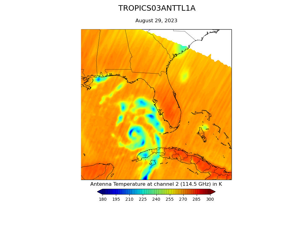
TROPICS03 L1A Orbital Geolocated Native-Resolution Antenna Temperatures V0.2
National Aeronautics and Space Administration —
The "Time-Resolved Observations of Precipitation structure and storm Intensity with a Constellation of Smallsats" (TROPICS) mission has a goal of providing nearly... -
Federal
GPM ATMS on NOAA-21 (GPROF) Radiometer Precipitation Profiling L2A 1.5 hours 17 km V07 (GPM_2AGPROFNOAA21ATMS) at GES DISC
National Aeronautics and Space Administration —
Version 07 is the current version of the data set. The 2AGPROF (also known as, GPM GPROF (Level 2)) algorithm retrieves consistent precipitation and related science... -
Federal
OMI/Aura Formaldehyde (HCHO) Total Column Daily L3 Weighted Mean Global 0.1deg Lat/Lon Grid V003 (OMHCHOd) at GES DISC
National Aeronautics and Space Administration —
The OMI/Aura Formaldehyde (HCHO) Total Column Daily L3 Weighted Mean Global 0.1deg Lat/Lon Grid (OMHCHOd). The formaldehyde values in each file are the average for... -
Federal
AIRS/Aqua L1B Infrared (IR) geolocated and calibrated radiances V005 (AIRIBRAD) at GES DISC at GES DISC
National Aeronautics and Space Administration —
WARNING: On 2021/09/23 the EOS Aqua executed a Deep Space Maneuver (DSM). In the DSM, the spacecraft is turned such that the normal Earth field of regard is deep... -
Federal
AIRS/Aqua L1B Near Real Time (NRT) Infrared (IR) geolocated and calibrated radiances V005 (AIRIBRAD_NRT) at GES DISC
National Aeronautics and Space Administration —
WARNING: On 2021/09/23 the EOS Aqua executed a Deep Space Maneuver (DSM). In the DSM, the spacecraft is turned such that the normal Earth field of regard is deep... -
Federal
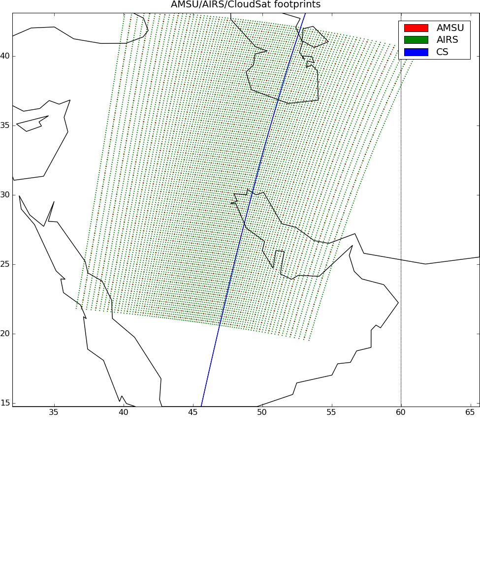
AIRS-CloudSat cloud mask, radar reflectivities, and cloud classification matchups V3.2 (AIRS_CPR_MAT) at GES DISC
National Aeronautics and Space Administration —
This is AIRS-CloudSat collocated subset, in NetCDF-4 format. These data contain collocated: AIRS Level 1b radiances spectra, CloudSat radar reflectivities, and MODIS... -
Federal
Carbon Monitoring System Carbon Flux FossilFuel Prior L4 V3 (CMSFluxFossilFuelPrior)
National Aeronautics and Space Administration —
This dataset provides the Prior for the Fossil Fuel Carbon Flux. The NASA Carbon Monitoring System (CMS) is designed to make significant contributions in... -
Federal
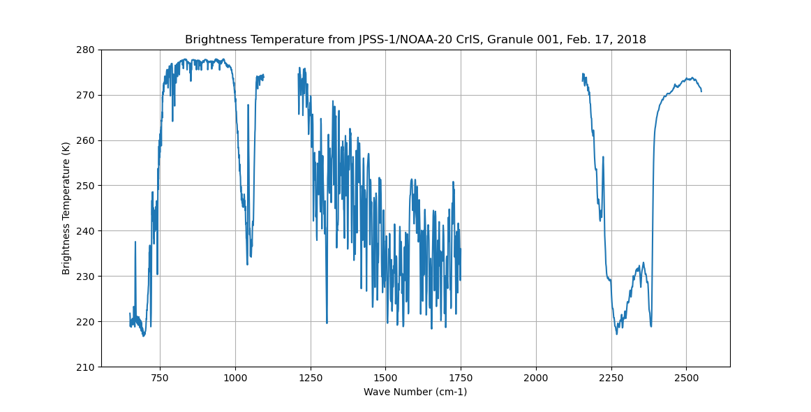
Sounder SIPS: Sun Synchronous 13:30 orbit Climate Hyperspectral InfraRed Product (CHIRP): Calibrated Radiances from JPSS-1/NOAA-20, V2 (SNDR13CHRP1J1Cal) at GES DISC
National Aeronautics and Space Administration —
The Climate Hyperspectral Infrared Radiance Product (CHIRP) is a Level 1 radiance product derived from Atmospheric Infrared Sounder (AIRS) on EOS-AQUA and the Cross-... -
Federal
MLS/Aura Level 3 Monthly Binned Nitric Acid (HNO3) Mixing Ratio on Assorted Grids V004 (ML3MBHNO3) at GES DISC
National Aeronautics and Space Administration —
ML3MBHNO3 is the EOS Aura Microwave Limb Sounder (MLS) monthly binned on various vertical grids product for nitric acid (HNO3) derived from radiances measured by the... -
Federal
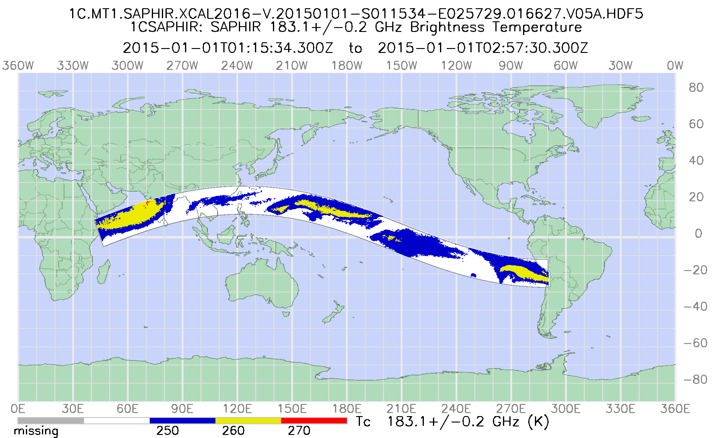
GPM SAPHIR on MT1 Common Calibrated Brightness Temperature L1C 1.5 hours 10 km V07 (GPM_1CMT1SAPHIR) at GES DISC
National Aeronautics and Space Administration —
Version 07 is the current version of the data set. Older versions will no longer be available and have been superseded by Version 07. 1CAMSR2 contains common... -
Federal
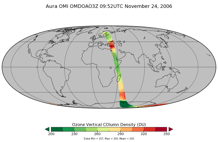
OMI/Aura DOAS Total Column Ozone Zoomed 1-Orbit L2 Swath 13x12km V003 (OMDOAO3Z) at GES DISC
National Aeronautics and Space Administration —
The reprocessed Aura Ozone Monitoring Instrument (OMI) Level-2 Zoomed Ozone data product OMDOAO3Z at 13x12 km resolution is now available from the NASA Goddard Earth...

Official websites use .gov
A
.gov website belongs to an official government
organization in the United States.
Secure .gov websites use HTTPS
A
lock (
) or https:// means you’ve safely connected to
the .gov website. Share sensitive information only on official,
secure websites.