
-
Federal
BlueFlux: Dissolved Carbon and Greenhouse Gases
National Aeronautics and Space Administration —
This dataset provides dissolved carbon (dissolved inorganic carbon and dissolved organic carbon), greenhouse gases, dissolved organic matter optical, and hydrological... -
Federal
PnET-BGC: Modeling Biogeochemical Processes in a Northern Hardwood Forest Ecosystem
National Aeronautics and Space Administration —
This archived model product contains the directions, executables, and procedures for running PnET-BGC to recreate the results of: Gbondo-Tugbawa, S.S., C.T. Driscoll... -
Federal
Land Surface Model (LSM 1.0) for Ecological, Hydrological, Atmospheric Studies
National Aeronautics and Space Administration —
The NCAR LSM 1.0 is a land surface model developed to examine biogeophysical and biogeochemical land-atmosphere interactions, especially the effects of land surfaces... -
Federal
Biome-BGC: Modeling Carbon Dynamics in Ponderosa Pine Stands (Law et al. 2003)
National Aeronautics and Space Administration —
This archived model product contains the directions, executables, and procedures for running Biome-BGC, Version 4.1.2, to recreate the results of the following... -
Federal
Integrated Biosphere Simulator Model (IBIS), Version 2.5
National Aeronautics and Space Administration —
The Integrated Biosphere Simulator (or IBIS) is designed to be a comprehensive model of the terrestrial biosphere. Tthe model represents a wide range of processes,... -
Federal
CENTURY: Modeling Ecosystem Responses to Climate Change, Version 4 (VEMAP 1995)
National Aeronautics and Space Administration —
The CENTURY model, Version 4, is a general model of plant-soil nutrient cycling that is being used to simulate carbon and nutrient dynamics for different types of... -
Federal
VEMAP 2: U.S. Annual Climate Change Scenarios
National Aeronautics and Space Administration —
Data sets of transient climate change scenarios based on coupled atmosphere-ocean general circulation model (AOGCM) transient climate experiments with transient... -
Federal
VEMAP 1: U.S. Site Files
National Aeronautics and Space Administration —
An integrated input data set for ecosystem and vegetation modeling for the conterminous United States: Site Files -
Federal
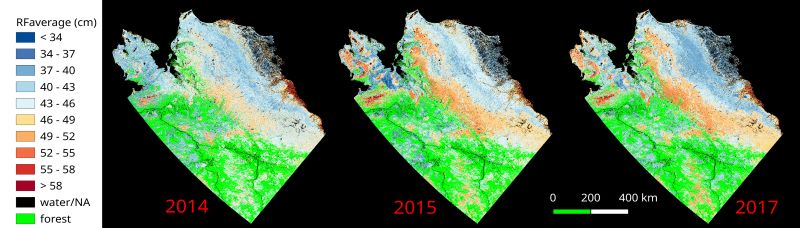
ABoVE: Upscaled Active Layer Thickness in Northern Alaska, 2014-2017
National Aeronautics and Space Administration —
The dataset consists of maps of estimated Active Layer Thickness (ALT) at 30-m resolution throughout the northern half of Alaska for the years 2014, 2015, and 2017.... -
Federal
VEMAP 2: U.S. Monthly Climate Change Scenarios, Version 2
National Aeronautics and Space Administration —
Data sets of transient climate change scenarios based on coupled atmosphere-ocean general circulation model (AOGCM) transient climate experiments with transient... -
Federal
BOREAS Follow-On DSP-04 1994 ERS-1 Level-4 Landscape Freeze/Thaw Maps, Ver. 1.0
National Aeronautics and Space Administration —
The BOREAS DSP-4 team acquired and analyzed imaging radar data from the ESA's ERS-1 over a complete annual cycle at the BOREAS sites in Canada in 1994 to detect... -
Federal
BOREAS Follow-On HMet-02 Area and Regional Hourly Gridded Met. Data, 1994-1996
National Aeronautics and Space Administration —
Phase II and III gridded data sets have been generated by an objective analysis scheme using all of the surface meteorological station data over BOREAS region for... -
Federal
Aircraft Flux-Raw: NRCC (FIFE)
National Aeronautics and Space Administration —
Raw (unmodified) boundary layer fluxes recorded on aircraft flights over Konza -
Federal
Temperature Profiles: Radiosonde (FIFE)
National Aeronautics and Space Administration —
Temperature & humidity profile data derived from Brutsaert's radiosonde data -
Federal
Soil Moisture Gravimetric Data (FIFE)
National Aeronautics and Space Administration —
Soil moisture collected at 25mm, 75mm, and 150mm -
Federal
NMC Upper Air Derived Data (FIFE)
National Aeronautics and Space Administration —
NMC interpolated upper air condition data received from NESDIS -
Federal
SE-590 Ground Data: GSFC (FIFE)
National Aeronautics and Space Administration —
Bidirectional reflectances measured with SE590 (Middleton) -
Federal
LiDAR and DTM Data from Forested Land Near Manaus, Amazonas, Brazil, 2008
National Aeronautics and Space Administration —
This data set provides LiDAR point clouds and digital terrain models (DTM) from surveys over the K34 tower site in the Cuieiras Biological Reserve, over forest... -
Federal
Surface Meteorology Data: NCDC (FIFE)
National Aeronautics and Space Administration —
NCDC surface meteorology data for 1989 -
Federal
Eddy Corr. Surface Flux: USGS (FIFE)
National Aeronautics and Space Administration —
FIFE observations of surface fluxes

Official websites use .gov
A
.gov website belongs to an official government
organization in the United States.
Secure .gov websites use HTTPS
A
lock (
) or https:// means you’ve safely connected to
the .gov website. Share sensitive information only on official,
secure websites.