
-
Federal
MASTER: Student Airborne Research Program (SARP) Campaign, California, 2009
National Aeronautics and Space Administration —
This dataset includes Level 1B (L1B) data products from the MODIS/ASTER Airborne Simulator (MASTER) instrument collected and developed by the Student Airborne... -
Federal
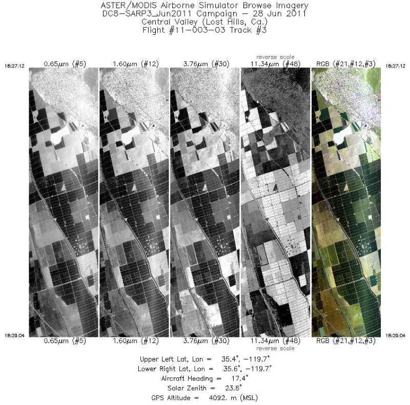
MASTER: Student Airborne Research Program (SARP) Campaign, California, 2011
National Aeronautics and Space Administration —
This dataset includes Level 1B (L1B) data products from the MODIS/ASTER Airborne Simulator (MASTER) instrument collected and developed by the Student Airborne... -
Federal
MASTER: Airborne Science, southwestern US, June, 2000
National Aeronautics and Space Administration —
This dataset includes Level 1B (L1B) data products from the MODIS/ASTER Airborne Simulator (MASTER) instrument. The spectral data were collected during 12 flights... -
Federal
MASTER: Airborne Science, California-Nevada, August, 2004
National Aeronautics and Space Administration —
This dataset includes Level 1B (L1B) data products from the MODIS/ASTER Airborne Simulator (MASTER) instrument. The spectral data were collected during one flight... -
Federal
BOREAS Level-2 MAS Surface Reflectance and Temperature Images in BSQ Format
National Aeronautics and Space Administration —
MAS images, along with other remotely sensed data, were collected to provide spatially extensive information over the primary study areas. This information includes... -
Federal
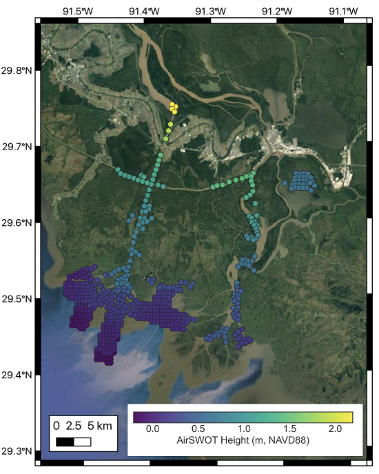
Delta-X: AirSWOT L3 Water Surface Elevations, MRD, Louisiana, 2021
National Aeronautics and Space Administration —
This dataset contains water surface elevations at selected point locations generated from the AirSWOT data collected during the Spring and Fall 2021 Delta-X... -
Federal
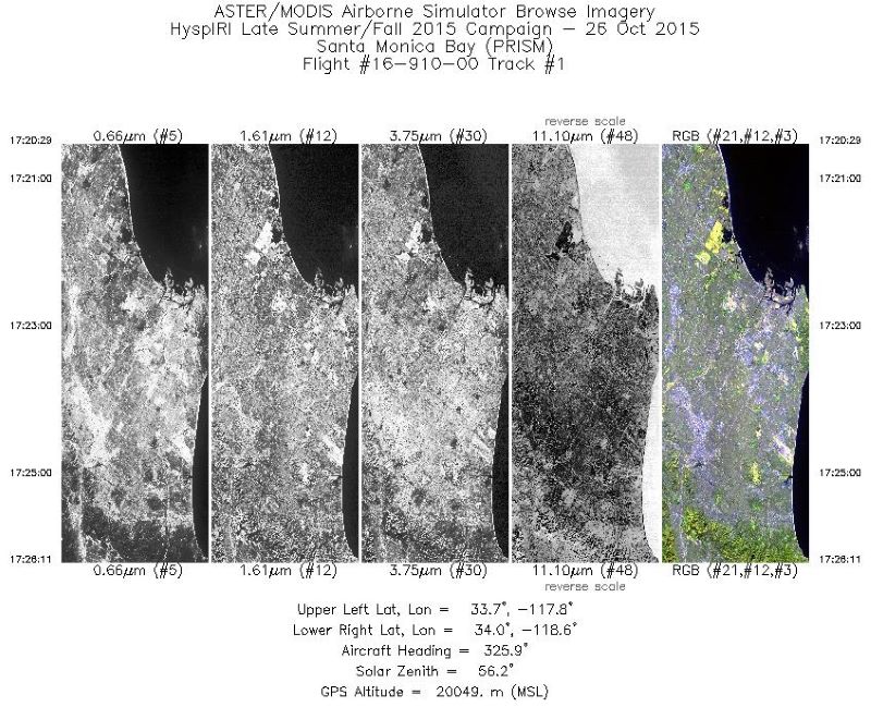
MASTER: HyspIRI Airborne Campaign, California, Fall 2015
National Aeronautics and Space Administration —
This dataset includes Level 1B (L1B) and Level 2 (L2) data products from the MODIS/ASTER Airborne Simulator (MASTER) instrument. The spectral data were collected as... -
Federal
AfriSAR: Canopy Structure Derived from PolInSAR and Coherence TomoSAR NISAR tools
National Aeronautics and Space Administration —
This dataset contains forest vertical structure and associated uncertainty products derived by applying multi-baseline Polarimetric Interferometric Synthetic Aperture... -
Federal
ABoVE: Wetland Inundation Coverage at Yukon Flats, AK and PA Delta, Canada, 2017-2019
National Aeronautics and Space Administration —
This dataset provides time series of wetland inundation coverage maps and corresponding inundation frequency maps at ~10-meter resolution estimated every 12 days... -
Federal
ATom: Ultrafine Aerosol Characteristics and Formation, Lower Stratosphere, 2016-2018
National Aeronautics and Space Administration —
This dataset consists of (a) selected aerosol and gas-phase observations made on all four deployments of NASA Atmospheric Tomography Mission (ATom), (b) thermodynamic... -
Federal
ACT-America: Profile-based Planetary Boundary Layer Heights, Eastern USA
National Aeronautics and Space Administration —
This dataset provides profile-based estimates of the height to the top of the planetary boundary layer (PBL), also known as the atmospheric boundary layer (ABL), in... -
Federal
NACP Regional: Original Observation Data and Biosphere and Inverse Model Outputs
National Aeronautics and Space Administration —
This data set contains the originally-submitted observation measurement data, terrestrial biosphere model output data, and inverse model simulations that various... -
Federal
LBA-ECO TG-07 Trace Gas Fluxes, Undisturbed and Logged Sites, Para, Brazil: 2000-2002
National Aeronautics and Space Administration —
Trace gas fluxes of carbon dioxide, methane, nitrous oxide, and nitric oxide were measured manually at undisturbed and logged forest sites in the Tapajos National... -
Federal
MASTER: California Fire-Burn Area Emergency Response, California, April 2008
National Aeronautics and Space Administration —
This dataset includes Level 1B (L1B) data products from the MODIS/ASTER Airborne Simulator (MASTER) instrument. The spectral data were collected as part of the... -
Federal
LBA-ECO ND-04 Termite Mound and Soil Characterization, Amazonas, Brazil: 1999-2001
National Aeronautics and Space Administration —
This data set reports the results of a comprehensive study of mound building termites at the Embrapa research station in the Distrito Agropecuario da SUFRAMA, located... -
Federal
ABoVE: Ignitions, Burned Area, and Emissions of Fires in AK, YT, and NWT, 2001-2018 NGDA
National Aeronautics and Space Administration —
This dataset provides estimates of daily burned area, carbon emissions, and uncertainty, and daily fire ignition locations for boreal fires in Alaska, U.S., and in... -
Federal
Arctic Vegetation Plots at Prudhoe Bay, Alaska, 1973-1980
National Aeronautics and Space Administration —
This data set provides environmental, soil, and vegetation data collected between 1973 and 1980 from 89 study plots in the Prudhoe Bay region of Alaska. Data includes... -
Federal
Digital Elevation Models for the Global Change Research Wetland, Maryland, USA, 2016
National Aeronautics and Space Administration —
This dataset contains four alternative digital elevation models (DEMs) at 1 m resolution and model performance statistical metrics for the Global Change Research... -
Federal
ABoVE: TVPRM Simulated Net Ecosystem Exchange, Alaskan North Slope, 2008-2017 NGDA
National Aeronautics and Space Administration —
This dataset includes hourly net ecosystem exchange (NEE) simulated by the Tundra Vegetation Photosynthesis and Respiration Model (TVPRM) at 30 km horizontal...

Official websites use .gov
A
.gov website belongs to an official government
organization in the United States.
Secure .gov websites use HTTPS
A
lock (
) or https:// means you’ve safely connected to
the .gov website. Share sensitive information only on official,
secure websites.