
-
Federal
ABoVE: Rain-on-Snow Frequency and Distribution during Cold Seasons, Alaska, 2003-2016 NGDA
National Aeronautics and Space Administration —
This dataset provides maps of rain-on-snow (ROS) events across Alaska for the individual months of November to March 2002-2011 and November to March 2012-2016, and... -
Federal
Arctic Vegetation Plots in Northern NWT and YT, Canada, 1965-1966
National Aeronautics and Space Administration —
This dataset provides vegetation, soil, and plot characteristics for 154 study plots located at three sites across the Richardson Mountains, Northwest Territories... -
Federal
MASTER: FIREX-AQ Airborne Campaign, Western-Central USA, Summer 2019
National Aeronautics and Space Administration —
This dataset includes Level 1B (L1B) and Level 2 (L2) data products from the MODIS/ASTER Airborne Simulator (MASTER) instrument. The spectral data were collected as... -
Federal
Remote Sensing Data Before and After California Rim and King Forest Fires, 2010-2015
National Aeronautics and Space Administration —
This data set provides high-resolution surface reflectance, thermal imagery, burn severity metrics, and LiDAR-derived structural measures of forested areas in the... -
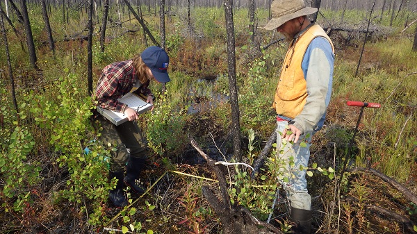
Federal
ABoVE: Post-Fire and Unburned Vegetation Community and Field Data, NWT, Canada, 2018
National Aeronautics and Space Administration —
This dataset provides vegetation community characteristics and biophysical data collected in 2018 from areas that were burned by wildfire in 2014 and 2015, and from... -
Federal
Global Distribution of Plant-Extractable Water Capacity of Soil (Dunne)
National Aeronautics and Space Administration —
Plant-extractable water capacity of soil is the amount of water that can be extracted from the soil to fulfill evapotranspiration demands. This data set provides an... -
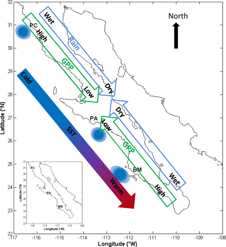
Federal
CMS: MODIS GPP, fPAR, and SST, and ENSO Index, Baja California, Mexico, 2000-2013 NGDA
National Aeronautics and Space Administration —
This data set provides data for MODIS-derived (1) gross primary productivity (GPP) for the years 2000-2010, (2) fraction of photosynthetically active radiation (fPAR)... -
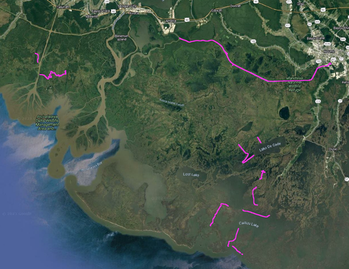
Federal
Delta-X: In-situ Water Surface Elevation, MRD, Louisiana, USA, 2021
National Aeronautics and Space Administration —
This dataset contains water surface elevations collected from boat surveys performed on August 24 and September 22-25, 2021, across the Atchafalaya and Terrebonne... -
Federal
LBA-ECO TG-03 Aeronet Aerosol Optical Thickness Measurements, Brazil: 1993-2005
National Aeronautics and Space Administration —
This data set includes aerosol optical thickness measurements from the CIMEL sunphotometer for 22 sites in Brazil during the period from 1993-2005. The AERONET... -
Federal
BOREAS TE-10 Leaf Chemistry Data
National Aeronautics and Space Administration —
Leaf chemistry data collected by TE-10. Contains 3 granules: 1) biochemical data; 2) biochemical data on a per dry weight basis; and 3) biochemical carbon, hydrogen,... -
Federal
AVIRIS-NG L1B Calibrated Radiance, Facility Instrument Collection, V1
National Aeronautics and Space Administration —
This dataset contains Level 1B (L1B) orthocorrected, scaled radiance image files as well as files of observational geometry and illumination parameters and supporting... -
Federal
BOREAS TE-06 1994 Soil and Air Temperatures in the NSA
National Aeronautics and Space Administration —
Contains soil temperature data collected by TE-06 during the BOREAS project. -
Federal
Pre-Delta-X: Channel Bathymetry of the Atchafalaya Basin, LA, USA, 2016
National Aeronautics and Space Administration —
This dataset provides water depths and water surface elevations collected during bathymetric surveys of the main channel of the Wax Lake Delta within the Mississippi... -
Federal
BOREAS TE-01 Soils Data over the SSA Tower Sites in Raster Format
National Aeronautics and Space Administration —
Gridded from vector layers of soil maps that were received from Dr. Darwin Anderson TE-01, who did the original soil mapping in the field during 1994. The vector... -
Federal
ISLSCP II University of Maryland Global Land Cover Classifications, 1992-1993
National Aeronautics and Space Administration —
The objective of the International Satellite Land Surface Climatology Project (ISLSCP II) study that produced this data set, ISLSCP II University of Maryland Global... -
Federal
BOREAS RSS-07 Regional LAI and FPAR Images From Ten-Day AVHRR-LAC Composites
National Aeronautics and Space Administration —
The BOREAS RSS-07 team collected various data sets to develop and validate an algorithm to allow the retrieval of the spatial distribution of LAI from remotely sensed... -
Federal
BOREAS RSS-14 Level-3 Gridded Radiometer and Satellite Surface Radiation Images
National Aeronautics and Space Administration —
The BOREAS RSS-14 team collected and processed GOES-7 and -8 images of the BOREAS region as part of their effort to characterize the incoming, reflected and emitted... -
Federal
BOREAS Daedalus TMS Level-0 Imagery: Digital Counts in BIL Format
National Aeronautics and Space Administration —
The level-0 Daedalus TMS imagery, along with the other remotely sensed images, was collected to provide spatially extensive information about radiant energy over the... -
Federal
BOREAS Site and Area Geographic Coordinate Information
National Aeronautics and Space Administration —
Geographic coordinate and other site information from several sources throughout the experiment period. The final set of information is organized into two data sets... -
Federal
CMS: Mangrove Forest Cover Extent and Change across Major River Deltas, 2000-2016
National Aeronautics and Space Administration —
This dataset provides estimates of mangrove extent for 2016, and mangrove change (gain or loss) from 2000 to 2016, in major river delta regions of eight countries:...

Official websites use .gov
A
.gov website belongs to an official government
organization in the United States.
Secure .gov websites use HTTPS
A
lock (
) or https:// means you’ve safely connected to
the .gov website. Share sensitive information only on official,
secure websites.