
-
Federal
BOREAS Landsat TM Level-3s Imagery: Scaled At-Sensor Radiance in LGSOWG Format
National Aeronautics and Space Administration —
For BOREAS, the level-3s Landsat TM data, along with the other remotely sensed images, were collected in order to provide spatially extensive information over the... -
Federal
BOREAS/SRC AMS Suite A Surface Meteorological and Radiation Data: 1996
National Aeronautics and Space Administration —
Contains the data collected in 1996 by the AMS suite A instrument set operated by SRC and provided to BORIS. -
Federal
Tidal Wetlands Soil Organic Carbon and Estuarine Characteristics, USA, 1972-2015
National Aeronautics and Space Administration —
This dataset provides a synthesis of soil organic carbon (SOC) estimates and a variety of other environmental information from tidal wetlands within estuaries in the... -
Federal
Vulcan: High-Resolution Annual Fossil Fuel CO2 Emissions in USA, 2010-2015, Version 3
National Aeronautics and Space Administration —
The Vulcan version 3.0 annual dataset provides estimates of annual carbon dioxide (CO2) emissions from the combustion of fossil fuels (FF) and CO2 emissions from... -
Federal
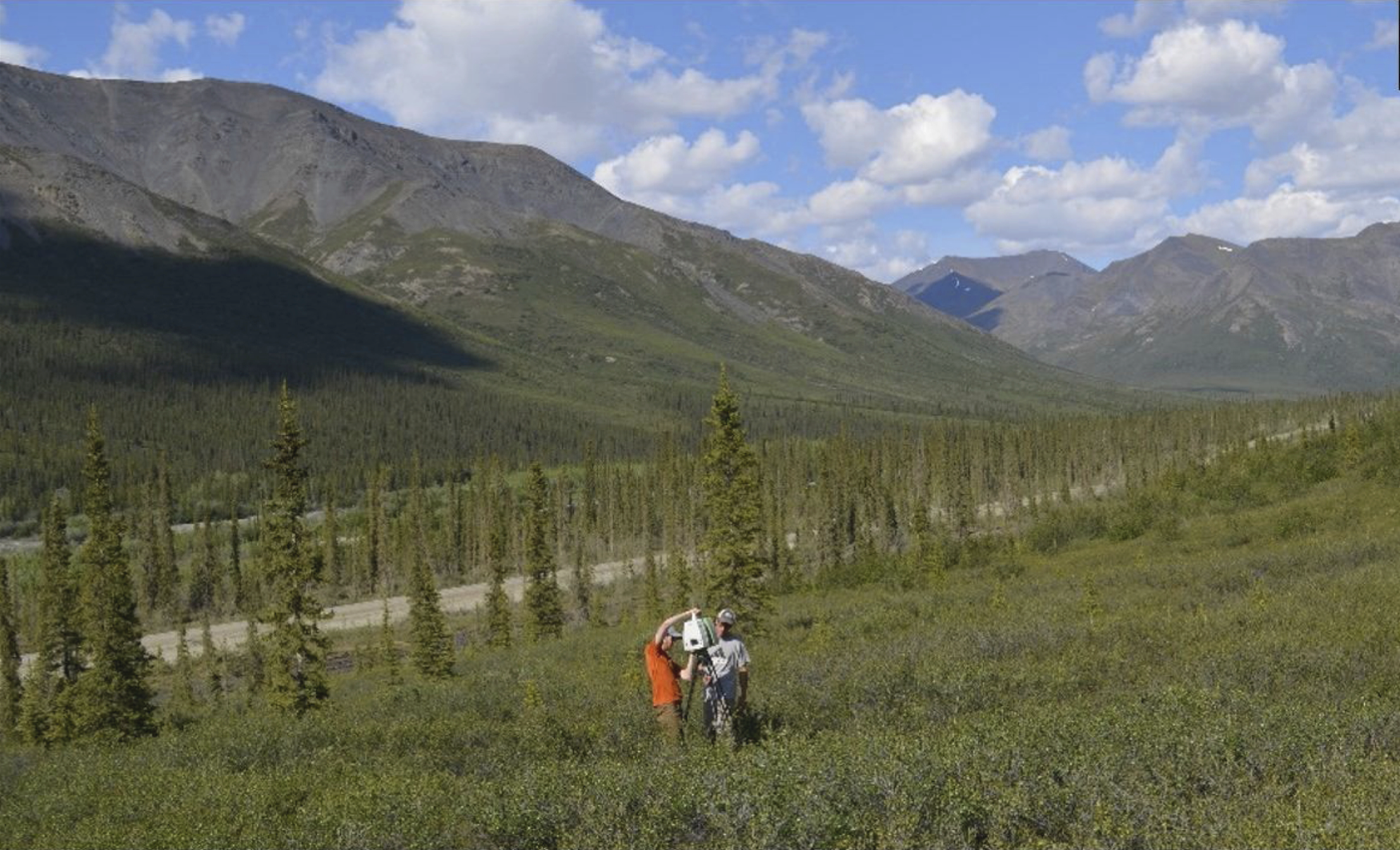
ABoVE: Terrestrial Lidar Scanning Forest-Tundra Ecotone, Brooks Range, Alaska, 2016
National Aeronautics and Space Administration —
This dataset provides terrestrial lidar scanning (TLS) point cloud data collected at 10 research plots along the forest-tundra ecotone (FTE) in the Brooks Range of... -
Federal
Global Data Set of Derived Soil Properties, 0.5-Degree Grid (ISRIC-WISE)
National Aeronautics and Space Administration —
The World Inventory of Soil Emission Potentials (WISE) database was used to generate a series of uniform data sets of derived soil properties for each of the 106 soil... -
Federal
BOREAS TGB-06 Soil Methane Oxidation and Production from NSA BP and Fen Sites
National Aeronautics and Space Administration —
Contains 1993, 1994, and 1996 methane concentrations from TGB-06 in the NSA and SSA. -
Federal
BOREAS HYD-04 Standard Snow Course Data
National Aeronautics and Space Administration —
Contains the standard snow course data collected at various sites in the NSA and SSA by HYD-04. -
Federal
Global Wetland Methane Emissions derived from FLUXNET and the UpCH4 Model, 2001-2018
National Aeronautics and Space Administration —
This dataset provides monthly globally gridded freshwater wetland methane emissions from 2001-2018 in nmol CH4 m-2 s-1, g C-CH4 m-2 d-1, and TgCH4 grid cell-1... -
Federal
Tree Canopy Cover for the Circumpolar Taiga-Tundra Ecotone: 2000-2005 NGDA
National Aeronautics and Space Administration —
This data set provides a map of selected areas with defined tree canopy cover over the circumpolar taiga-tundra ecotone (TTE). Canopy cover was derived from the... -
Federal
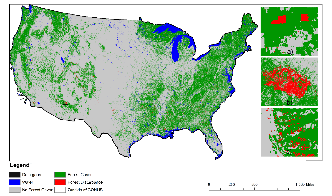
NACP NAFD Project: Forest Disturbance History from Landsat, 1986-2010
National Aeronautics and Space Administration —
The North American Forest Dynamics (NAFD) products provided in this data set consist of 25 annual and two time-integrated forest disturbance maps for the conterminous... -
Federal
BOREAS TGB-05 Biogenic Soil Emissions of NO and Nitrous Oxide
National Aeronautics and Space Administration —
Contains the TGB-05 NO and N2O flux data for sites in the Northern Study Area. -
Federal
Burned and Unburned Field Site Data, Noatak, Seward, and North Slope, AK, 2016-2018
National Aeronautics and Space Administration —
This dataset includes field measurements from unburned and burned 10 m x 10 m and 1 m x 1 m plots in the Noatak, Seward, and North Slope regions of the Alaskan tundra... -
Federal
MASTER: HyspIRI Airborne Campaign, California, Spring 2015
National Aeronautics and Space Administration —
This dataset includes Level 1B (L1B) and Level 2 (L2) data products from the MODIS/ASTER Airborne Simulator (MASTER) instrument. The spectral data were collected as... -
Federal
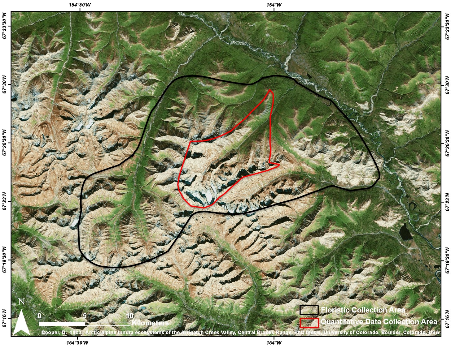
Arctic Vegetation Plots at Arrigetch Peaks, Alaska, 1978-1981
National Aeronautics and Space Administration —
This data set provides environmental and vegetation data collected between 1978 and 1981 from 439 study plots at Arrigetch Peaks research site, located in the Gates... -
Federal
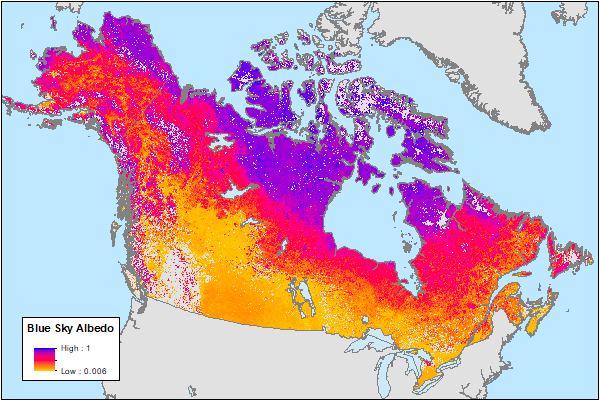
ABoVE: MODIS-Derived Daily Mean Blue Sky Albedo for Northern North America, 2000-2017 NGDA
National Aeronautics and Space Administration —
This dataset contains MODIS-derived daily mean shortwave blue sky albedo for northern North America (i.e., Canada and Alaska) and a set of quality control flags for... -
Federal
Arctic Vegetation Plots, Prudhoe Bay ArcSEES Road Study, Lake Colleen, Alaska, 2014
National Aeronautics and Space Administration —
This dataset provides environmental, soil, and vegetation data collected from study plots in the vicinity of Lake Colleen off the Spine Road at Prudhoe Bay, Alaska,... -
Federal
Delta-X: UAVSAR L1 Single Look Complex (SLC) Stack Products, MRD, Louisiana, 2021
National Aeronautics and Space Administration —
This dataset contains UAVSAR Level 1 (L1) Single Look Complex (SLC) stack products for Delta-X flight lines acquired during 2021-03-27 to 2021-04-18 (spring) and... -
Federal
Tidal Wetland Soil Carbon Stocks for the Conterminous United States, 2006-2010
National Aeronautics and Space Administration —
This dataset provides modeled estimates of soil carbon stocks for tidal wetland areas of the Conterminous United States (CONUS) for the period 2006-2010. Wetland... -
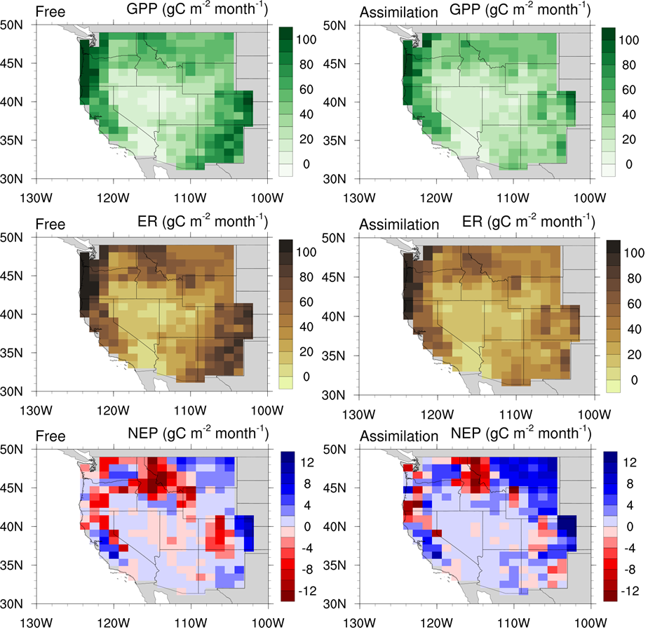
Federal
CLM5-DART Regional Carbon Fluxes and Stocks over the Western US, 1998-2010
National Aeronautics and Space Administration —
This dataset provides monthly estimates of biomass stocks and land-atmosphere carbon exchange across the western United States at 0.95 degrees longitude x 1.25...

Official websites use .gov
A
.gov website belongs to an official government
organization in the United States.
Secure .gov websites use HTTPS
A
lock (
) or https:// means you’ve safely connected to
the .gov website. Share sensitive information only on official,
secure websites.