
-
Federal
NOAA NEXt-Generation RADar (NEXRAD) Products NGDA 98 recent views
National Oceanic and Atmospheric Administration, Department of Commerce —
This dataset consists of Level III weather radar products collected from Next-Generation Radar (NEXRAD) stations located in the contiguous United States, Alaska,... -
Federal
Maritime Limits and Boundaries of United States of America NGDA 42 recent views
National Oceanic and Atmospheric Administration, Department of Commerce —
NOAA is responsible for depicting on its nautical charts the limits of the 12 nautical mile Territorial Sea, 24 nautical mile Contiguous Zone, and 200 nautical mile... -
Federal
Sea turtle population study in the coastal waters of North Carolina from 1988-06-07 to 2015-09-22 (NCEI Accession 0162846) 30 recent views
National Oceanic and Atmospheric Administration, Department of Commerce —
This data set contains sea turtle length and weight measurements, sex ratios, species composition, capture and release locations, tagging information, and information... -
Federal
Atlantic Surfclam and Ocean Quahog Survey
National Oceanic and Atmospheric Administration, Department of Commerce —
The standardized NEFSC Atlantic Surfclam and Ocean Quahog Survey has covered an area from Cape Hatteras to Georges Bank. The survey was conducted every two or three... -
Federal
MarineCadastre.gov
National Oceanic and Atmospheric Administration, Department of Commerce —
MarineCadastre.gov is a marine information system that provides authoritative ocean data, offshore planning tools, and technical support to the offshore renewable... -
Federal
Shoreline Mapping Program of HEAD OF GREEN BAY TO PESHTIGO POINT, INCLUDING FOX RIVER TO DE PERE, WI, WI1001G-CM-N NGDA
National Oceanic and Atmospheric Administration, Department of Commerce —
These data provide an accurate high-resolution shoreline compiled from imagery of HEAD OF GREEN BAY TO PESHTIGO POINT, INCLUDING FOX RIVER TO DE PERE, WI . This... -
Federal
Tampa Bay , Florida 1/3 arc-second NAVD 88 Coastal Digital Elevation Model
National Oceanic and Atmospheric Administration, Department of Commerce —
NOAA's National Geophysical Data Center (NGDC) is building high-resolution digital elevation models (DEMs) for select U.S. coastal regions. These integrated... -
Federal
Shoreline Mapping Program of Bass Islands, Lake Erie, OH, OH1603-CM-N NGDA
National Oceanic and Atmospheric Administration, Department of Commerce —
These data provide an accurate high-resolution shoreline compiled from imagery of Bass Islands, Lake Erie, OH . This vector shoreline data is based on an office... -
Federal
2016 NOAA NGS Topobathy Lidar: Sugarloaf Key to Big Pine Key, Florida
National Oceanic and Atmospheric Administration, Department of Commerce —
These data were collected by NOAA using a Riegl VQ880G sensor. The data were acquired from October 11, 2016 through October 24, 2016. The data includes topobathy data... -
Federal
Offshore Oil and Gas Platforms
National Oceanic and Atmospheric Administration, Department of Commerce —
These data show the location for oil and gas platforms located in the state and federal waters of the United States. Generally, this data set does not show platforms... -
Federal
H10749A: NOS Hydrographic Survey , Approaches to Port Everglades, Florida, 1998-06-10
National Oceanic and Atmospheric Administration, Department of Commerce —
The National Oceanic and Atmospheric Administration (NOAA) has the statutory mandate to collect hydrographic data in support of nautical chart compilation for safe... -
Federal
GEWEX SRB Integrated Product (Rel-4) Longwave Monthly Average by UTC Ocean-only Fluxes
National Aeronautics and Space Administration —
GEWEXSRB_Rel4-IP_Longwave_monthly_oceanonly_utc is the Global Energy and Water Exchanges (GEWEX) Surface Radiation Budget (SRB) Integrated Product (Rel-4) Longwave... -
Federal
Neutrally buoyant float data for the SPURS-1 N. Atlantic field campaign
National Aeronautics and Space Administration —
The SPURS (Salinity Processes in the Upper Ocean Regional Study) project is an oceanographic process study and associated field program that aim to elucidate key... -
Federal
Sound recordings and echolocation logs from Tuxedni Bay and Chinitna Bay, Cook Inlet, Alaska, September 2021 to September 2022
National Oceanic and Atmospheric Administration, Department of Commerce —
Sound recordings were made in Tuxedni Bay and Chinitna Bays, Cook Inlet, Alaska. These recordings (files.wav) were made from ST-600HF sound recorders (Ocean... -
Federal
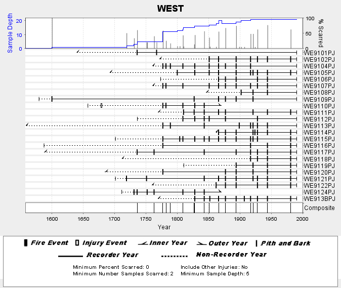
NOAA/WDS Paleoclimatology - Skinner fire data from WEST (San Pedro Martir) - IMPD MXWES001
National Oceanic and Atmospheric Administration, Department of Commerce —
This archived Paleoclimatology Study is available from the NOAA National Centers for Environmental Information (NCEI), under the World Data Service (WDS) for... -
Federal
Shoreline Mapping Program of Intracoastal Waterway, Dollar Bay to Johnson Bay, FL, FL1601D-CM-N NGDA
National Oceanic and Atmospheric Administration, Department of Commerce —
These data provide an accurate high-resolution shoreline compiled from imagery of Intracoastal Waterway, Dollar Bay to Johnson Bay, FL . This vector shoreline data is... -
Federal
Lake Hermitage Marsh Creation - NRDA Early Restoration Project (Project ID: 4)
National Oceanic and Atmospheric Administration, Department of Commerce —
After the Deepwater Horizon oil spill, federal and state agencies came together to form the Deepwater Horizon Natural Resource Damage Assessment Trustee Council. The... -
Federal
Shoreline Data Rescue Project of Everglades City to Venice, CM-7808 NGDA
National Oceanic and Atmospheric Administration, Department of Commerce —
These data were automated to provide an accurate high-resolution historical shoreline of Everglades City to Venice suitable as a geographic information system (GIS)... -
Federal
Shoreline Data Rescue Project of Tacoma Harbor, Washington, CM-7311 NGDA
National Oceanic and Atmospheric Administration, Department of Commerce —
These data were automated to provide an accurate high-resolution historical shoreline of Tacoma Harbor, Washington suitable as a geographic information system (GIS)... -
Federal
Shoreline Data Rescue Project of Beaufort Harbor, North Carolina, NC13A03 NGDA
National Oceanic and Atmospheric Administration, Department of Commerce —
These data were automated to provide an accurate high-resolution historical shoreline of Beaufort Harbor, North Carolina suitable as a geographic information system...

Official websites use .gov
A
.gov website belongs to an official government
organization in the United States.
Secure .gov websites use HTTPS
A
lock (
) or https:// means you’ve safely connected to
the .gov website. Share sensitive information only on official,
secure websites.