
-
Federal
Sea Ice Index, Version 3
National Aeronautics and Space Administration —
The Sea Ice Index provides a quick look at Arctic- and Antarctic-wide changes in sea ice. It is a source for consistent, up-to-date sea ice extent and concentration... -
Federal
Panama City, Florida optical measurements in 1993
National Aeronautics and Space Administration —
Measurements taken in the Gulf of Mexico near Panama City, Florida in 1993. -
Federal
GEWEX SRB Integrated Product (Rel-4) Longwave Monthly Average by UTC Ocean-only Fluxes
National Aeronautics and Space Administration —
GEWEXSRB_Rel4-IP_Longwave_monthly_oceanonly_utc is the Global Energy and Water Exchanges (GEWEX) Surface Radiation Budget (SRB) Integrated Product (Rel-4) Longwave... -
Federal
Neutrally buoyant float data for the SPURS-1 N. Atlantic field campaign
National Aeronautics and Space Administration —
The SPURS (Salinity Processes in the Upper Ocean Regional Study) project is an oceanographic process study and associated field program that aim to elucidate key... -
Federal
SMEX02 SMACEX Tower Meteorological/Flux Data: Iowa, Version 1
National Aeronautics and Space Administration —
Notice to Data Users: The documentation for this data set was provided solely by the Principal Investigator(s) and was not further developed, thoroughly reviewed, or... -
Federal
VIIRS validation measurements made in the Florida Keys
National Aeronautics and Space Administration —
Measurements made in the Florida Keys as part of efforts to Validate the VIIRS instrument. -
Federal
Moderate Resolution Imaging Spectroradiometer (MODIS) - Terra NGDA
National Aeronautics and Space Administration —
This dataset represents multiple products archived at the multiple archive centers for the MODIS (Moderate Resolution Imaging Spectroradiometer) instrument aboard the... -
Federal
JPL GRACE and GRACE-FO Mascon Ocean, Ice, and Hydrology Equivalent Water Height Coastal Resolution Improvement (CRI) Filtered Release 06.1 Version 03
National Aeronautics and Space Administration —
This dataset contains gridded monthly global water storage/height anomalies relative to a time-mean, derived from GRACE and GRACE-FO and processed at JPL using the... -
Federal
Moderate Resolution Imaging Spectroradiometer (MODIS) - Aqua NGDA
National Aeronautics and Space Administration —
This dataset represents multiple products archived at the multiple archive centers for the MODIS (Moderate Resolution Imaging Spectroradiometer) instrument aboard the... -
Federal
GHRSST Level 4 MUR Global Foundation Sea Surface Temperature Analysis (v4.1) NGDA
National Aeronautics and Space Administration —
A Group for High Resolution Sea Surface Temperature (GHRSST) Level 4 sea surface temperature analysis produced as a retrospective dataset (four day latency) and near-... -
Federal
Earth Radiation Budget Experiment (ERBE) S-10 Medium Field of View (MFOV) Shape Factor (SF) Radiant Flux and Albedo
National Aeronautics and Space Administration —
ERBE_S10_MFOV_SF_NAT_1 is the Earth Radiation Budget Experiment (ERBE) S-10 Medium Field of View (MFOV) Shape Factor (SF) Radiant Flux and Albedo data product. Data... -
Federal
Aquarius Official Release Level 3 Rain-flagged Sea Surface Salinity Standard Mapped Image Descending 28-Day Running Mean Data V5.0
National Aeronautics and Space Administration —
Aquarius Level 3 sea surface salinity (SSS) rain-flagged standard mapped image data contains gridded 1 degree spatial resolution SSS averaged over daily, 7 day,... -
Federal
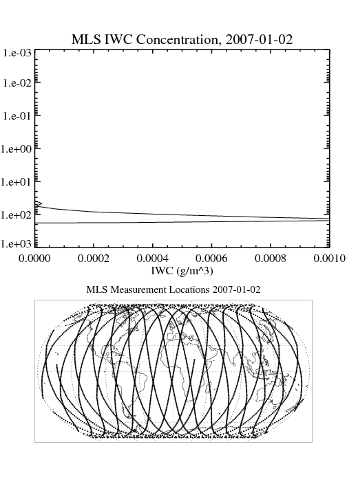
MLS/Aura Level 2 Cloud Ice Product V004 (ML2IWC) at GES DISC
National Aeronautics and Space Administration —
ML2IWC is the EOS Aura Microwave Limb Sounder (MLS) standard product for cloud ice water content derived from radiances measured by the 240 GHz radiometer. The data... -
Federal
GHRSST NOAA/STAR GOES-17 ABI L3C America Region SST v2.71 dataset in GDS2
National Aeronautics and Space Administration —
The ACSPO G17/ABI L3C (Level 3 Collated) product is a gridded version of the ACSPO G17/ABI L2P product available at... -
Federal
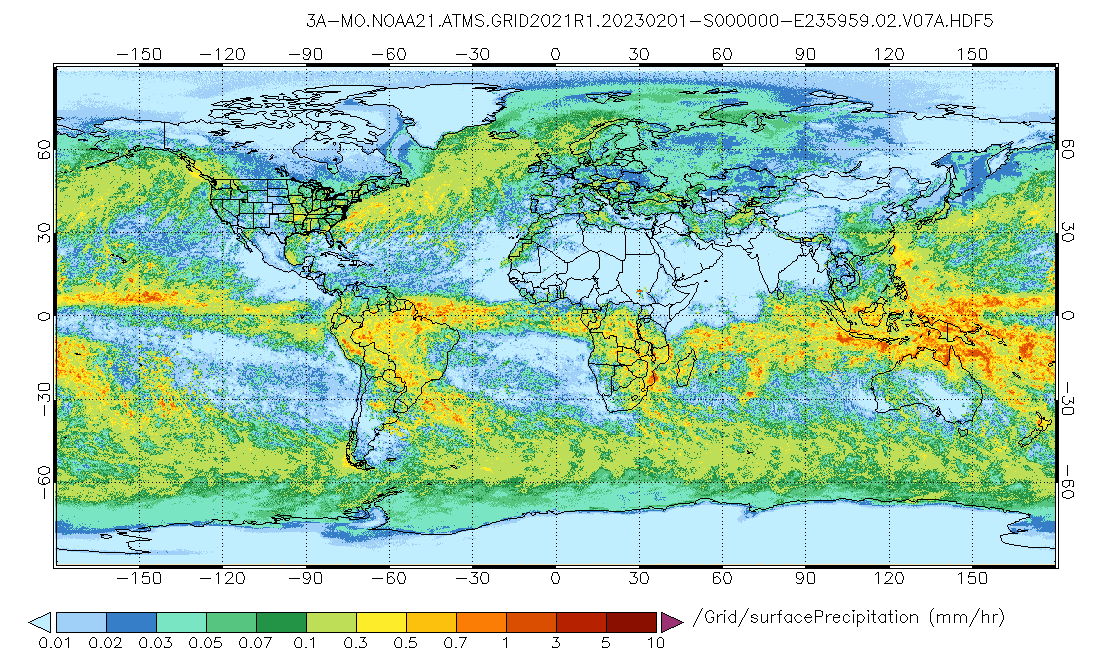
GPM ATMS on NOAA-21 (GPROF) Radiometer Precipitation Profiling L3 1 month 0.25 degree x 0.25 degree V07 (GPM_3GPROFNOAA21ATMS) at GES DISC
National Aeronautics and Space Administration —
Version 07 is the current version of the data set. 3GPROF products provide global gridded monthly/daily precipitation averages from multiple satellites that can be... -
Federal
GPM Ground Validation Optical Disdrometer (ODM) LPVEx V1
National Aeronautics and Space Administration —
The GPM Ground Validation Optical Disdrometer (ODM) LPVEx dataset consists of precipitation particle size distribution data collected by the Eigenbrodt Optical... -
Federal
Geochemistry, Phytoplankton, and Color of the Ocean (GePCO) program
National Aeronautics and Space Administration —
Measurements taken during 2001 under the Geochemistry, Phytoplankton, and Color of the Ocean (GePCO) program. -
Federal
Sentinel-6A MF Jason-CS L2 P4 Altimeter Low Resolution (LR) NRT Reduced Ocean Surface Topography
National Aeronautics and Space Administration —
Provides low resolution (LR) near real time (NRT; 3-hour latency) measurements of sea surface height anomaly (SSHA), Significant Wave Height (SWH), and Wind Speed.... -
Federal
Trichonesia cruise
National Aeronautics and Space Administration —
Measurements from Indonesia made during 1998. -
Federal
Radiostratigraphy and Age Structure of the Greenland Ice Sheet V001
National Aeronautics and Space Administration —
This data set contains the traced deep radiostratigraphy of the Greenland Ice Sheet from airborne deep ice-penetrating radar data collected by The University of...

Official websites use .gov
A
.gov website belongs to an official government
organization in the United States.
Secure .gov websites use HTTPS
A
lock (
) or https:// means you’ve safely connected to
the .gov website. Share sensitive information only on official,
secure websites.