
-
Federal
Texas_Oysters_2011
National Oceanic and Atmospheric Administration, Department of Commerce —
1985 Gulf of Mexico Atlas abstract American oyster Crassostrea virginica Ostión americano Description Range: The American oyster, a bivalve mollusc of the family... -
Federal
Florida_Oysters_2011
National Oceanic and Atmospheric Administration, Department of Commerce —
1985 Gulf of Mexico Atlas abstract American oyster Crassostrea virginica Ostión americano Description Range: The American oyster, a bivalve mollusc of the family... -
Federal
F00653: NOS Hydrographic Survey , 2015-10-15
National Oceanic and Atmospheric Administration, Department of Commerce —
The National Oceanic and Atmospheric Administration (NOAA) has the statutory mandate to collect hydrographic data in support of nautical chart compilation for safe... -
Federal
H09294: NOS Hydrographic Survey , Wire Drag Delaware Bay Entrance, Delaware, 1972-06-27
National Oceanic and Atmospheric Administration, Department of Commerce —
The National Oceanic and Atmospheric Administration (NOAA) has the statutory mandate to collect hydrographic data in support of nautical chart compilation for safe... -
Federal
H12572: NOS Hydrographic Survey , Delaware Bay and Approaches, 2013-09-16
National Oceanic and Atmospheric Administration, Department of Commerce —
The National Oceanic and Atmospheric Administration (NOAA) has the statutory mandate to collect hydrographic data in support of nautical chart compilation for safe... -
Federal
Louisiana_Oysters_2011
National Oceanic and Atmospheric Administration, Department of Commerce —
1985 Gulf of Mexico Atlas abstract American oyster Crassostrea virginica Ostión americano Description Range: The American oyster, a bivalve mollusc of the family... -
Federal
GOM_Oysters_DigitalAtlas2011
National Oceanic and Atmospheric Administration, Department of Commerce —
American oyster Crassostrea virginica Description Range: The American oyster, a bivalve mollusc of the family Ostreidae, is found in the western Atlantic from the... -
Federal
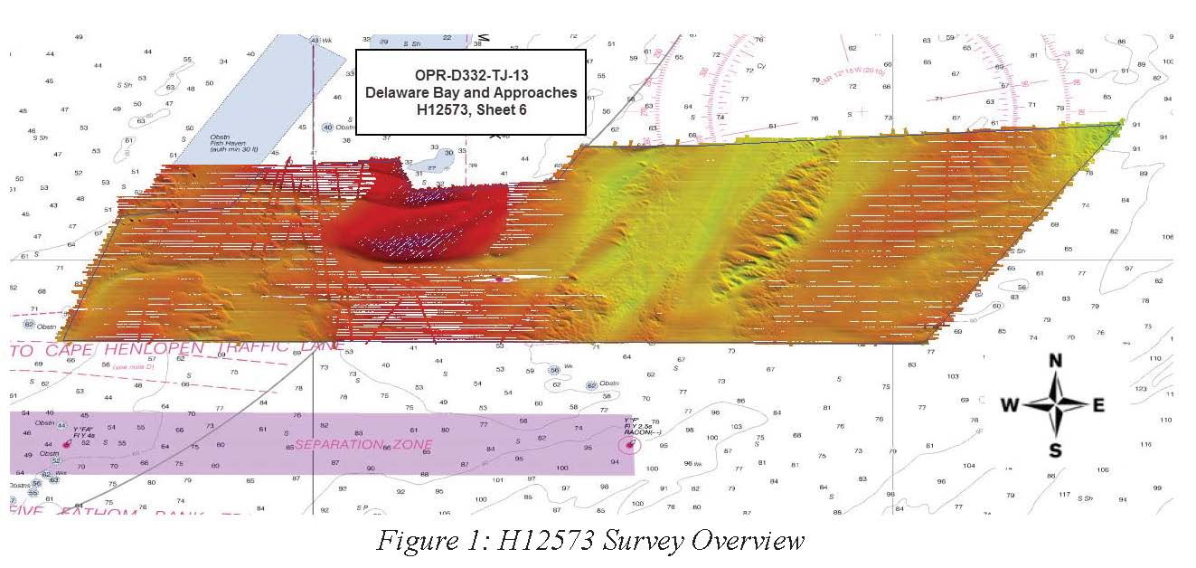
H12573: NOS Hydrographic Survey , Delaware Bay and Approaches, 2013-09-30
National Oceanic and Atmospheric Administration, Department of Commerce —
The National Oceanic and Atmospheric Administration (NOAA) has the statutory mandate to collect hydrographic data in support of nautical chart compilation for safe... -
Federal
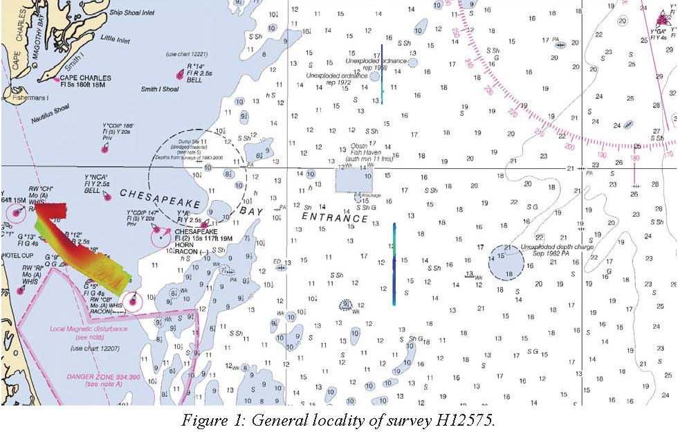
H12575: NOS Hydrographic Survey , Approaches to Chesapeake Bay, 2013-07-30
National Oceanic and Atmospheric Administration, Department of Commerce —
The National Oceanic and Atmospheric Administration (NOAA) has the statutory mandate to collect hydrographic data in support of nautical chart compilation for safe... -
Federal
F00789: NOS Hydrographic Survey , 2019-10-25
National Oceanic and Atmospheric Administration, Department of Commerce —
The National Oceanic and Atmospheric Administration (NOAA) has the statutory mandate to collect hydrographic data in support of nautical chart compilation for safe... -
Federal
H12666: NOS Hydrographic Survey , 2014-10-09
National Oceanic and Atmospheric Administration, Department of Commerce —
The National Oceanic and Atmospheric Administration (NOAA) has the statutory mandate to collect hydrographic data in support of nautical chart compilation for safe... -
Federal
Alabama_Oysters_2011
National Oceanic and Atmospheric Administration, Department of Commerce —
1985 Gulf of Mexico Atlas abstract American oyster Crassostrea virginica Ostión americano Description Range: The American oyster, a bivalve mollusc of the family... -
Federal
Mississippi_Oysters_2011
National Oceanic and Atmospheric Administration, Department of Commerce —
1985 Gulf of Mexico Atlas abstract American oyster Crassostrea virginica Ostión americano Description Range: The American oyster, a bivalve mollusc of the family... -
Federal
B00018: NOS Hydrographic Survey , 1985-07-02
National Oceanic and Atmospheric Administration, Department of Commerce —
The National Oceanic and Atmospheric Administration (NOAA) has the statutory mandate to collect hydrographic data in support of nautical chart compilation for safe... -
Federal
AIS Ship Traffic: Hawaii: 2011-2012
National Oceanic and Atmospheric Administration, Department of Commerce —
Ship position data from a satellite-based Automatic Identification System (AIS) were obtained jointly by PacIOOS (J. Potemra), SOEST/ORE of the University of Hawaii... -
Federal
AIS Ship Traffic: Johnston Atoll: 2011-2012
National Oceanic and Atmospheric Administration, Department of Commerce —
Ship position data from a satellite-based Automatic Identification System (AIS) were obtained jointly by PacIOOS (J. Potemra), SOEST/ORE of the University of Hawaii... -
Federal
PacIOOS Wave Buoy 163: Kalo, Majuro, Marshall Islands
National Oceanic and Atmospheric Administration, Department of Commerce —
Wave buoy 163 measures wave height, wave direction, wave period, and water temperature in the vicinity of Delap Point on the east shore of Majuro Atoll in the... -
Federal
AIS Ship Traffic: Mariana and Wake: 2011-2012
National Oceanic and Atmospheric Administration, Department of Commerce —
Ship position data from a satellite-based Automatic Identification System (AIS) were obtained jointly by PacIOOS (J. Potemra), SOEST/ORE of the University of Hawaii... -
Federal
AIS Ship Traffic: Rose Atoll: 2011-2012
National Oceanic and Atmospheric Administration, Department of Commerce —
Ship position data from a satellite-based Automatic Identification System (AIS) were obtained jointly by PacIOOS (J. Potemra), SOEST/ORE of the University of Hawaii...

Official websites use .gov
A
.gov website belongs to an official government
organization in the United States.
Secure .gov websites use HTTPS
A
lock (
) or https:// means you’ve safely connected to
the .gov website. Share sensitive information only on official,
secure websites.