

27 datasets found
-
Federal
Utah FORGE: Seismic Reflection Data
Department of Energy —
This is 2D and 3D seismic reflection data from Utah FORGE reprocessed during Phase 2c. The readme file containing an explanation of the data including data formats,... -
Federal
Utah FORGE: Earthquake Catalog
Department of Energy —
This is the set of earthquake catalogs developed for the Utah FORGE project covering December of 2016 through March of 2018. These are discussed in the "Utah FORGE... -
Federal
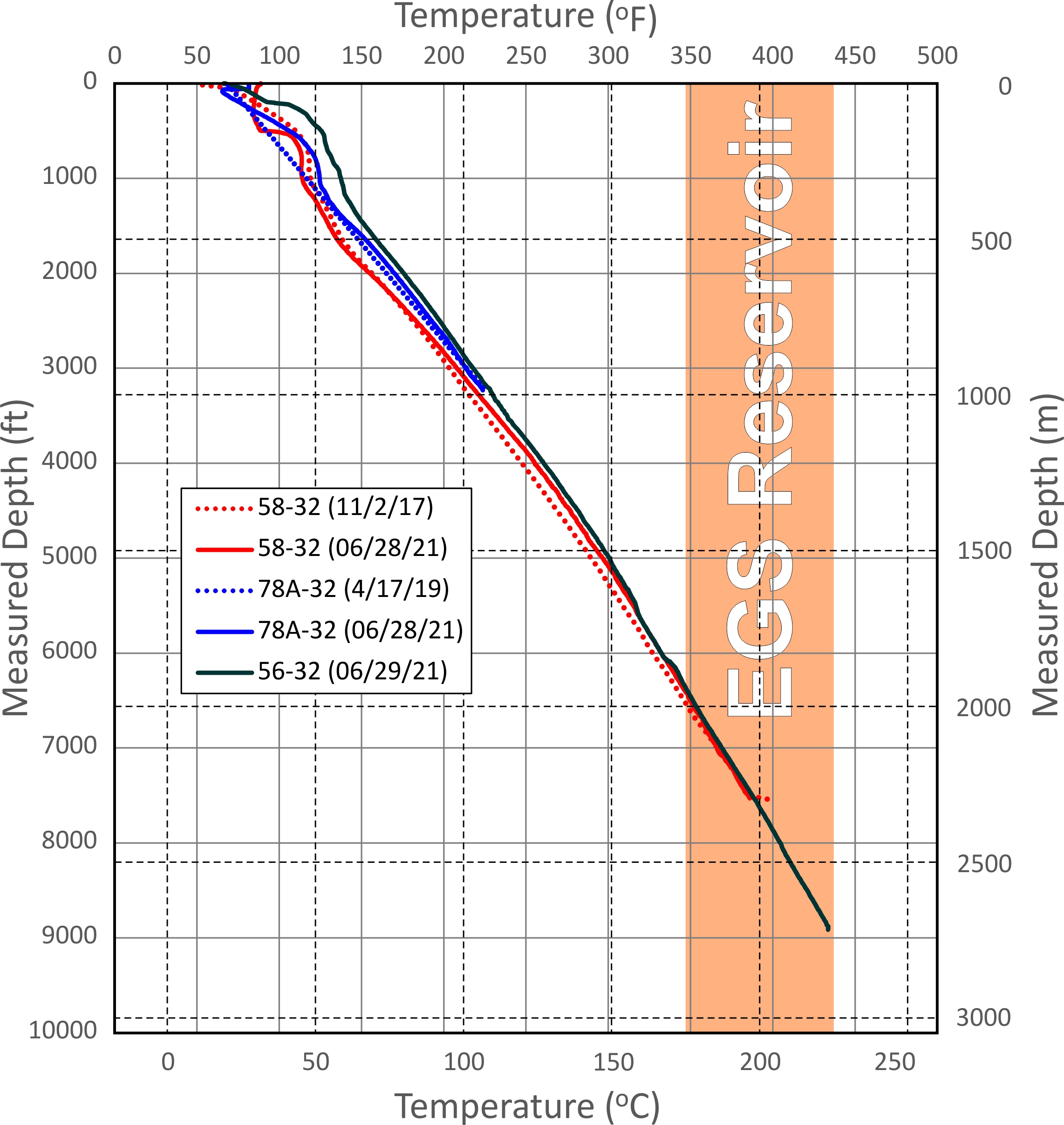
Utah FORGE Wells Updated Temperature and Pressure Logs (June 2021)
Department of Energy —
This dataset includes updated temperature and pressure logs for Utah FORGE wells 56-32, 78-32, and 58-32. This data was acquired in June 2021. -
Federal
Utah FORGE: GIS Well Temperature Data
Department of Energy —
This is a GIS point feature shapefile representing wells, and their temperatures, that are located in the general Utah FORGE area near Milford, Utah. There are also... -
Federal
Utah FORGE Phase Native State FALCON Model Files
Department of Energy —
The submission includes FALCON input file and mesh for the an initial pressure-temperature simulation, and a second set for pressure-temperature-displacement... -
Federal
Utah FORGE: TEM and Gravity Data
Department of Energy —
This submission includes a gravity data in text format and as a GIS point shapefile and transient electromagnetic (TEM) raw data. Each text file additionally contains... -
Federal
Utah FORGE: Microseismic Events
Department of Energy —
This archive contains Excel spreadsheets containing microseismic events detected in the study area during Utah FORGE Phase 2C. The Readme file included that describes... -
Federal
Utah FORGE: Area Terrain Slope Data
Department of Energy —
This archive contains a terrain slope image, in units of degrees, of the Utah FORGE area near Roosevelt Hot springs. The data was derived from 0.5 m resolution LiDAR... -
Federal
Utah FORGE: Drilling Data for Student Competition
Department of Energy —
Diagnostic drilling data (Pason log files) from Well 58-32 (previously labeled MU-ESW1), which was drilled near Milford Utah during Phase 2B of the FORGE Project to... -
Federal
Utah FORGE: Temperature Contours at 200 m
Department of Energy —
The individual shapefiles in this dataset delineate estimated temperature contours (20, 40, 60, and 80 deg C) at a depth of 200 m in the Milford, Utah FORGE area.... -
Federal
Utah FORGE: Milford Gravity Data Shapefile
Department of Energy —
This is a zipped GIS compatible shapefile of gravity data points used in the Milford, Utah FORGE project as of March 21st, 2016. The shapefile is native to ArcGIS,... -
Federal
Utah FORGE: Heat Flow Contours and Well Data
Department of Energy —
This submission contains a shapefile of heat flow contour lines around the FORGE site located in Milford, Utah. The model was interpolated from data points in the... -
Federal
Utah FORGE: Roosevelt Hot Springs Analytical Well-Based Temperature Model Data
Department of Energy —
This submission contains a cumulative record of one-dimensional temperature modeling based off of well data in the vicinity of the Utah FORGE site. Temperature log... -
Federal
Utah FORGE: Area LiDAR Bare Earth DEM Mosaic
Department of Energy —
This is a mosaic of 154 bare earth DEM panels (0.5 m resolution) acquired during Phase II of the Utah FORGE project. The DEM covers the western Mineral Mountains and... -
Federal
Utah FORGE: Satellite Imagery and Digital Aerial Photography
Department of Energy —
This is a link to the USGS Global Visualization Viewer which can be used to locate and download a variety of remotely sensed data including the ASTER multispectral... -
Federal
SubTER Final Magnetotelluric (MT) Data: Mineral Mountains, Utah
Department of Energy —
Subsurface Science, Technology and Engineering Research, and Development (SubTER) Crosscut is a collaboration across the Department of Energy offices involved in... -
Federal
Utah FORGE UGS Interactive Geoscience Map
Department of Energy —
This is a link to the Utah Geological Survey's Utah FORGE Interactive Geoscience Map. The map layers include information on geology, geography, subsurface...
27 datasets found