
-
Federal
GTOPO30 Hydro 1K
National Aeronautics and Space Administration —
HYDRO1k is a geographic database developed to provide comprehensive and consistent global coverage of topographically derived data sets, including streams, drainage... -
Federal
Global Pesticide Grids (PEST-CHEMGRIDS), Version 1.01
National Aeronautics and Space Administration —
The Global Pesticide Grids (PEST-CHEMGRIDS), Version 1.01 data set contains 20 of the most-used pesticide active ingredients on 6 dominant crops and 4 aggregated crop... -
Federal
Pre SWOT Hydrology GRRATS Virtual Station River Heights Version 2
National Aeronautics and Space Administration —
The Global River Radar Altimeter Time Series (GRRATS) are simulated river gauge data that are derived from ERS-1, ERS-2, TOPEX/Poseidon OSTM/Jason-2, Jason-3 and... -
Federal
ABoVE: Lake Growing Season Green Surface Reflectance Trends, AK and Canada, 1984-2019
National Aeronautics and Space Administration —
This dataset provides an annual time series of Landsat green surface reflectance and the derived annual trend during the growing season (June and July) for 472,890... -
Federal
Pre-Delta-X: River Discharge Channel Surveys across Atchafalaya Basin, LA, USA, 2016
National Aeronautics and Space Administration —
This dataset provides river discharge measurements collected at selected locations across the Atchafalaya River Basin, within the Mississippi River Delta (MRD)... -
Federal
Pre SWOT Hydrology Global Lake/Reservoir Surface Inland Water Area Extent V2 NGDA
National Aeronautics and Space Administration —
The Global Lake/Reservoir Surface Inland Water Extent Mask Time Series are derived from the MODIS instruments. The purpose of this dataset is to provide surface water... -
Federal
MODIS/Aqua Water Reservoir Monthly L3 Global V061 NGDA
National Aeronautics and Space Administration —
The Aqua Moderate Resolution Imaging Spectroradiometer (MODIS) Water Reservoir Monthly Level 3 (L3) Global (MYD28C3) Version 6.1 product provides current data for 151... -
Federal
Pre SWOT Hydrology GRRATS Daily River Heights and Storage Version 2
National Aeronautics and Space Administration —
The Global River Radar Altimeter Time Series (GRRATS) 1km/daily interpolations are river heights from ERS-1, ERS-2, TOPEX/Poseidon OSTM/Jason-2 and Envisat that are... -
Federal
ISLSCP II HYDRO1k Elevation-derived Products
National Aeronautics and Space Administration —
This data set contains coarse scale elevation and elevation-based parameters at 1.0 and 0.5-degree spatial resolutions that were developed to support a wide variety... -
Federal
BOREAS TGB-09 Above-canopy NMHC at SSA-OBS, SSA-OJP and SSA-OA Sites
National Aeronautics and Space Administration —
Contains the mixing ratio and concentration of Non-Methane HydroCarbons (NMHC) taken by the TGB-09 group. -
Federal
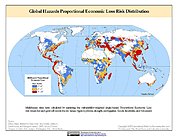
Global Multihazard Proportional Economic Loss Risk Deciles
National Aeronautics and Space Administration —
The Global Multihazard Proportional Economic Loss Risks is a 2.5 minute grid of a multihazard-based economic loss risk as a proportion of the economic productivity of... -
Federal
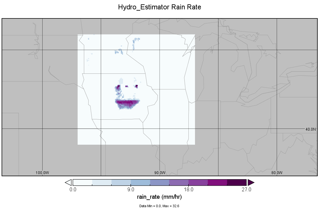
GPM Ground Validation Hydro-Estimator IFloodS V1
National Aeronautics and Space Administration —
The GPM Ground Validation Hydro-Estimator IFloodS dataset contains rainfall rate estimates derived using NOAA’s Geostationary Operational Environmental Satellites... -
Federal
Pre SWOT Hydrology Global Lake/Reservoir Storage Time Series V2
National Aeronautics and Space Administration —
The Global Lake/Reservoir Storage Time Series is derived from the Surface Water Height Time Series and Surface Water Extent Mask Time Series products. The purpose of... -
Federal
GPM Ground Validation Reference Rainfall Data Product IFloodS V1
National Aeronautics and Space Administration —
The GPM Ground Validation Reference Rainfall Data Product IFloodS dataset contains hourly rainfall accumulation estimates over central and northeastern Iowa for the... -
Federal
Global-Gridded Daily Methane Emissions Climatology from Lake Systems, 2003-2015
National Aeronautics and Space Administration —
This dataset provides global gridded information on lake surface area and open water CH4 emissions at a resolution of 0.25-degree x 0.25-degree for an annual... -
Federal
MODIS/Terra Water Reservoir Monthly L3 Global V061 NGDA
National Aeronautics and Space Administration —
The Terra Moderate Resolution Imaging Spectroradiometer (MODIS) Water Reservoir Monthly Level 3 (L3) Global (MOD28C3) Version 6.1 product provides current data for... -
Federal
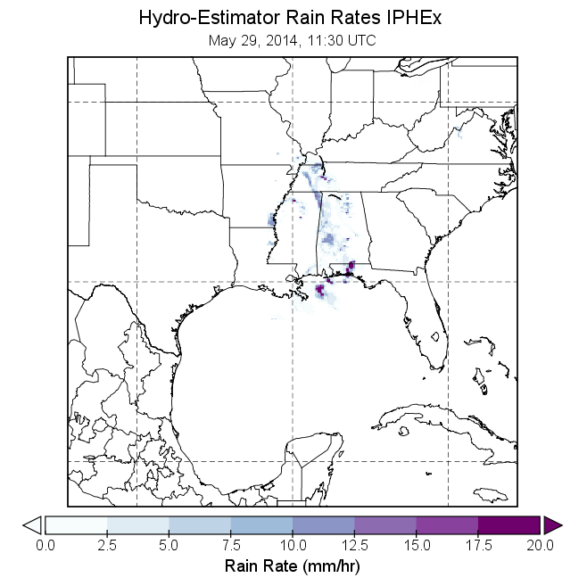
GPM Ground Validation Hydro-Estimator IPHEx V1
National Aeronautics and Space Administration —
The GPM Ground Validation Hydro-Estimator IPHEx dataset contains rainfall rate estimates derived using NOAA’s Geostationary Operational Environmental Satellites... -
Federal
Monthly Climate Data for Selected USGS HCDN Sites, 1951-1990, R1
National Aeronautics and Space Administration —
Time series of monthly minimum and maximum temperature, precipitation, and potential evapotranspiration were derived for 1,469 watersheds in the conterminous United... -
Federal
LBA Regional River Discharge Data (Coe and Olejniczak)
National Aeronautics and Space Administration —
This data set is a subset of a global river discharge data set by Coe and Olejniczak (1999). The subset was created for the study area of the Large Scale Biosphere-...

Official websites use .gov
A
.gov website belongs to an official government
organization in the United States.
Secure .gov websites use HTTPS
A
lock (
) or https:// means you’ve safely connected to
the .gov website. Share sensitive information only on official,
secure websites.