
-
Federal
Global Maps of Atmospheric Nitrogen Deposition, 1860, 1993, and 2050
National Aeronautics and Space Administration —
This data set provides global gridded estimates of atmospheric deposition of total inorganic nitrogen (N), NHx (NH3 and NH4+), and NOy (all oxidized forms of nitrogen... -
Federal
ABoVE: Photochemical Reflectance and Tree Growth, Brooks Range, Alaska, 2018-2019
National Aeronautics and Space Administration —
This dataset provides simultaneous in-situ measurements of the photochemical reflectance index (PRI) and radial tree growth of selected white spruce trees (Picea... -
Federal
CMS: LiDAR Data for Forested Areas in Paragominas, Para, Brazil, 2012-2014
National Aeronautics and Space Administration —
This data set provides raw LiDAR point cloud data and derived Digital Terrain Models (DTMs) for five forested areas in the municipality of Paragominas, Para, Brazil,... -
Federal
RLC Forest Cover of the Former Soviet Union, 1973
National Aeronautics and Space Administration —
This data set is a 1:15 million scale forest cover map for the land area of the Former Soviet Union. Twenty-two land cover classes are distinguished, of which 20 are... -
Federal
Global Gridded Surfaces of Selected Soil Characteristics (IGBP-DIS)
National Aeronautics and Space Administration —
Global data-surfaces pre-generated by SoilData, at a resolution of 5x5 arc-minutes, in ASCII GRID format for ARC INFO, and for the soil depth interval 0-100 cm. -
Federal
Global Soil Types, 0.5-Degree Grid (Modified Zobler)
National Aeronautics and Space Administration —
A global data set of soil types is available at 0.5-degree latitude by 0.5-degree longitude resolution. There are 106 soil units, based on Zobler's (1986) assessment... -
Federal
SAFARI 2000 MOPITT Tropospheric Carbon Monoxide, Southern Africa, Dry Season 2000
National Aeronautics and Space Administration —
The MOPITT (Measurements Of Pollution In The Troposphere) instrument on the NASA Terra Satellite makes measurements of infrared radiation originating from the surface... -
Federal
Characteristics of African Savanna Biomes for Determining Woody Cover
National Aeronautics and Space Administration —
This data set includes the soil and vegetation characteristics, herbivore estimates, and precipitation measurement data for the 854 sites described and analyzed in... -
Federal
CMS: Aboveground Biomass from Penobscot Experimental Forest, Maine, 2012
National Aeronautics and Space Administration —
This data set includes estimates of aboveground biomass (AGB) in 2012 from the Penobscot Experimental Forest (PEF) in Bradley, Maine. The AGB was modeled using LiDAR... -
Federal
FLUXNET Research Network Site Characteristics, Investigators, and Bibliography, 2016
National Aeronautics and Space Administration —
FLUXNET is a global network of micrometeorological tower sites that use eddy covariance methods to measure the exchanges of carbon dioxide, water vapor, and energy... -
Federal
RLC AVHRR-Derived Land Cover, Former Soviet Union, 15-km, 1984-1993
National Aeronautics and Space Administration —
This dataset is a 15-kilometer resolution land cover map for the land area of the Former Soviet Union. There are sixty land cover classes distinguished in this... -
Federal
RLC AVHRR-Derived Land Cover, Former Soviet Union, Far East, 1-km, 1990
National Aeronautics and Space Administration —
This data set is a 1-kilometer resolution land cover map for the land area of the Primor'ye and Southern Khabarovsk Regions, in the Russian Far East, based on 1990... -
Federal
RLC Forest Stand Carbon Map of Russia
National Aeronautics and Space Administration —
This dataset is a 1:15 million scale map of forest stand carbon for the land area of Russia (Stone et al., 2000). The objective was to create a first approximation of... -
Federal
Forest Inventories and DBH at Burned and Unburned Forest Sites, Acre, Brazil, 2017
National Aeronautics and Space Administration —
This data set provides measurements of diameter at breast height (DBH) and species identification at four forest sites in the eastern side of Acre, Brazil including... -
Federal
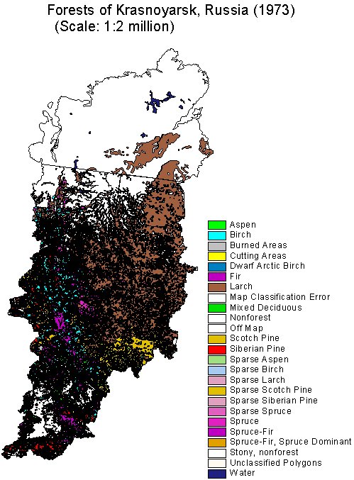
RLC Forest Cover of the Krasnoyarsk Region, Russia, 1973
National Aeronautics and Space Administration —
This dataset is a 1:2 million scale forest cover map for the land area of the Krasnoyarsk Region, Russia. Thirty-two land cover classes are distinguished. These data... -
Federal
RLC Generalized Forest Map of the Former Soviet Union, 1-km
National Aeronautics and Space Administration —
This data set is the Former Soviet Union (FSU) portion of the Generalized World Forest Map (WCMC, 1998), a 1-kilometer resolution generalized forest cover map for the... -
Federal
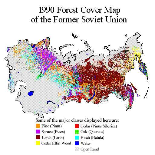
RLC Forest Cover Map of the Former Soviet Union, 1990
National Aeronautics and Space Administration —
This data set is a 1:2.5 million scale forest cover map for the land area of the Former Soviet Union that was completed in 1990 (Garsia 1990). There are forty-five... -
Federal
ECHIDNA LIDAR Campaigns: Forest Canopy Imagery and Field Data, U.S.A., 2007-2009
National Aeronautics and Space Administration —
This data set contains forest canopy scan data from the Echidna? Validation Instrument (EVI) and field measurements data from three campaigns conducted in the United... -
Federal
ABoVE: Vegetation Composition across Fire History Gradients on the Y-K Delta, Alaska
National Aeronautics and Space Administration —
This dataset provides ecological field data that were collected during July 2017 and July 2018 from 43 plots spanning gradients of fire history in the upland tundra... -
Federal
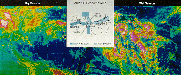
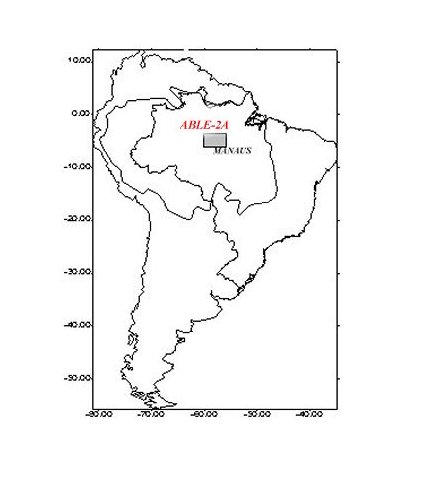
Pre-LBA ABLE-2A and ABLE-2B Expedition Data
National Aeronautics and Space Administration —
The ABLE 2A and 2B (Atmospheric Boundary Layer Experiments) data consists of estimates of the rate of exchange of a wide variety of aerosols and gases between the...

Official websites use .gov
A
.gov website belongs to an official government
organization in the United States.
Secure .gov websites use HTTPS
A
lock (
) or https:// means you’ve safely connected to
the .gov website. Share sensitive information only on official,
secure websites.